亲爱的小伙伴们大家好,欢迎来到两分钟论文导读。这次说的论文是用深度学习来生成3D地形。
关注公众号 袋马AI,回复 208 获取论文下载地址
We have recently witnessed the emergence of neural network-based techniques that are able to synthesize all sorts of images.
最近,能合成图片的神经网络技术大放异彩,这些技术可以合成各种各样的图片。
Our previous episode was about NVIDIA’s algorithm that created high resolution images of imaginary celebrities that was a really cool application of Generative Adersarial Networks.
之前我们介绍了NVIDIA的一个非常酷的生成对抗网络算法,这个算法创建了一系列假名人的高分辨率图片。
This architecture means that we have a pair of neural networks, one that learns to generate new images, and the other learns to tell a fake image from a real one.
这个结构中包含两部分网络,一部分网络用语生成逼真的图形,另一个网络用于判断哪些图片是生成出来的。


As they compete against each other, they get better and better without any human interation.
因为这两个网络相互竞争,因此无需人为干预,结果就会变得越来越好。
So We can clearly use them to create 2D images, but why stop there?
生成2D图形着这个网络来说已经是小儿科了,但我们为什么要止步于此呢。
Why not use this technique, for instance to create assets for digital media?
例如,为什么不使用这种技术创建些数字媒体资源呢?
Why instead of 2D images, let’s try to adapt these networks to generate high-resolution 3D models of terriains that we can use to populate a virtual world.
不仅仅是2D图像,我们可以用这个网络来生成高分辨率的3D地图模型,从而来构建一个虚拟的世界。
Both computer games and the motions picture industry could benefit greatly from such a tool.
从而让电脑游戏和影视公司等产科从这项工具中受益。
This process is typically done via procedural generation, whitch is basically a sort of guided random terrain generation.
这个程序可以依据引导随机生成地形。
Here, we can have a more direct effect on the output without putting in tens of hours of work to get the job done.
我们可以直接影响输出结果(生成的地形),从而省去数十小时的工作。
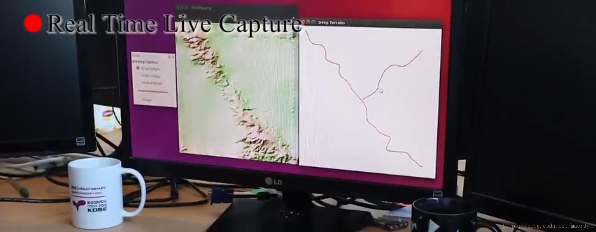
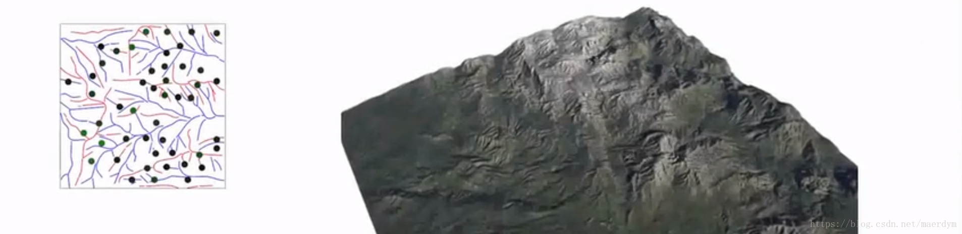
In the first training step, this technique learns how an image of a terrain corresponds to input drawings.
首先,该技术会通过学习将地形的图像与输入图形对应起来。
Then, we will be able to sketch a draft of a landscape with rivers, ridges, valleys and the algorithm will output a high quality model of the terrain itself.
然后,我们绘制地形中的河流、山脊、山谷,之后这个算法就可以输出高质量的地图模型啦。
During this process, we can have a look at the current output and refine out drawings in the meantime, leading to a super efficient process where we can go from a thought to a high-quality final result within a few seconds without being bogged down with the technical details.
在生成的过程中,我们可以通过调整我们的草图来输出想要的地图,从而让我们不必关系技术细节,在几秒钟内将想法输出成高质量的图形。
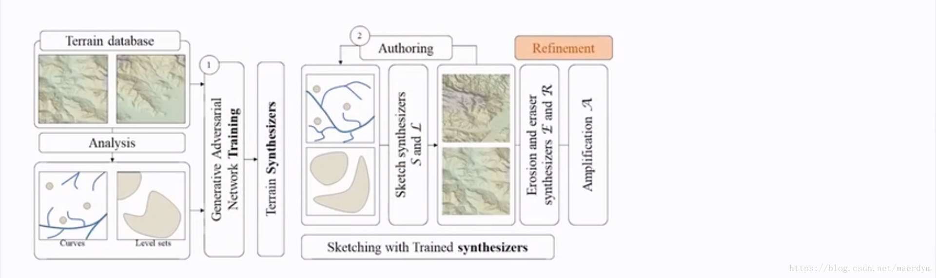
What’s more, it can also not only deal with erased subregions, but it can also automatically fill them with sensible information to save time for us.
而且,他们可以自动处理被擦擦的区域,并且自动填充合理的信息,从而帮我们节省大量的时间。
What an outstanding convenience feature!
这个特性真是太方便了(再也不怕老板让我改图了)。
And, the algorithm can also perform physical manipulations like erosion to the final results.
而且,这个算法还可以对结果进行物理处理,比如侵蚀等。
After the training for the erosion step is done, the computational cost is practically zero, for instance, running an erosion simulator on this piece of data would take around 40 seconds, whre the neural network can do it in 25 milliseconds.
执行侵蚀的训练后,再次进行侵蚀操作的计算成本几乎为0,比如,之前完成侵蚀操作需要40秒钟,而如果使用神经网络,只需要25毫秒就可以完成这一操作了。
The full simulation world almost be a minute where the network can mimic its results practically instantaneously.
之前完整的模拟一个世界需要一分钟左右,使用神经网络瞬间就可以完成这一工作了。
A limitation of this technique is that if the input is too sparse, unpleasant grid artifacts may appear.
这项技术的缺陷是,如果输入的数据太稀疏,可能会输出令人无法满意网格图像。
There are tons of more cool features in the paper, make sure to have a look, as always, it is available in the video description.
这篇论文中还提及了很多更酷的功能。
This is a really well thourght out and well-presented work that i expect to be a true powerhouse for terrain authoring int the future .
这确实是一项非常棒的想法,而且展现的成果也非常出色。我期望将来它能成为一款出色的地图生成工具。
好了,论文导读结束,更多的内容请详细阅读论文。
关注公众号 袋马AI,回复 208 获取论文下载地址
