1 从点云创建深度图像
#include <pcl/range_image/range_image.h>
int main (int argc, char** argv) {
pcl::PointCloud<pcl::PointXYZ> pointCloud;//定义点云对象
//生成数据
for (float y=-0.5f; y<=0.5f; y+=0.01f) {
for (float z=-0.5f; z<=0.5f; z+=0.01f) {
pcl::PointXYZ point;
point.x = 2.0f - y;
point.y = y;
point.z = z;
pointCloud.points.push_back(point); //添加点云数据到点云对象
}
}
pointCloud.width = (uint32_t) pointCloud.points.size();
pointCloud.height = 1;//设置点云对象的头信息
/************************************************************************************
这段程序首先创建一组数据作为点云的数据内容,在设置文件头文件的信息,整个实现生成一个呈现矩形形状的点云。
***************************************************************************/
//以1度为角分辨率,从上面创建的点云创建深度图像。
float angularResolution = (float) ( 1.0f * (M_PI/180.0f));
// 1度转弧度
float maxAngleWidth = (float) (360.0f * (M_PI/180.0f));
// 360.0度转弧度
float maxAngleHeight = (float) (180.0f * (M_PI/180.0f));
// 180.0度转弧度
Eigen::Affine3f sensorPose = (Eigen::Affine3f)Eigen::Translation3f(0.0f, 0.0f, 0.0f);//采集位置
pcl::RangeImage::CoordinateFrame coordinate_frame = pcl::RangeImage::CAMERA_FRAME;//深度图像遵循的坐标系统
float noiseLevel=0.00;
float minRange = 0.0f;
int borderSize = 1;
/************************************************************************************
其余代码使用用户给定的参数进行从点云创建深度图像,并且在终端下打印出一些深度图像的信息
***************************************************************************/
pcl::RangeImage rangeImage;
rangeImage.createFromPointCloud(pointCloud, angularResolution, maxAngleWidth, maxAngleHeight, sensorPose, coordinate_frame, noiseLevel, minRange, borderSize);
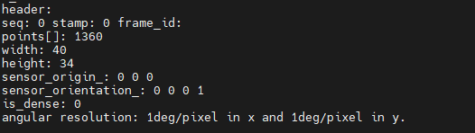
std::cout << rangeImage << "\n";
}
这部分定义了创建深度图像时需要的设置参数,将角分辩率定义为1°,意味着由邻近的像素点所对应的每个光束之间相差 1°;maxAngleWidth =360和maxAngleHeight=180意味着,我们进行模拟的距离传感器对周围的环境拥有一个完整的360°视角,用户在任何数据集下都可以使用此设置,因为最终获取的深度图像将被裁剪到有空间物体存在的区域范围。但是,用户可以通过减小数值来节省一些计算资源,例如:当传感器后面没有可以观测的点时,一个水平视角为180°的激光 扫描仪,即maxAngleWidth=180就足够了,这样只需要观察距离传感器前面就可以了,因为后面没有需要观察的场景。sensorPose 定义了模拟深度图像获取传感器的6自由度位置,其原始值为横滚角roll、 俯仰角pitch、偏航角yaw都为 0。coordinate_frame=CAMERA_ _FRAME 说明系统的X轴是向右的,Y轴是向下的,Z轴是向前的。另外一个选择是LASER_FRAME,其X轴向前,Y轴向左,Z轴向上。noiseLevel=0 是指使用一个归一化的Z缓冲器来创建深度图像,但是如果想让邻近点集都落在同一个像素单元,用户可以设置一个较高的值,例如noiseLevel =0. 05可以理解为,深度距离值是通过查询点半径为5cm的圆内包含的点以平均计算而得到的。如果minRange>0,则所有模拟器所在位置半minRange内的邻近点都将被忽略,即为盲区。在裁剪图像时,如果borderSize>0,将在图像周围留下当前视点不可见点的边界。

2 从深度图像中提取边界
/* \author Bastian Steder */
#include <iostream>
#include <boost/thread/thread.hpp>
#include <pcl/range_image/range_image.h>
#include <pcl/io/pcd_io.h>
#include <pcl/visualization/range_image_visualizer.h>
#include <pcl/visualization/pcl_visualizer.h>
#include <pcl/features/range_image_border_extractor.h>
#include <pcl/console/parse.h>
typedef pcl::PointXYZ PointType;
// --------------------
// -----参数-----
// --------------------
float angular_resolution = 0.5f;
pcl::RangeImage::CoordinateFrame coordinate_frame = pcl::RangeImage::CAMERA_FRAME;
bool setUnseenToMaxRange = false;
// --------------
// -----帮助-----
// --------------
void
printUsage (const char* progName)
{


  std::cout << "\n\nUsage: "<<progName<<" [options] <scene.pcd>\n\n"
            << "Options:\n"
            << "-------------------------------------------\n"
            << "-r <float>   angular resolution in degrees (default "<<angular_resolution<<")\n"
            << "-c <int>     coordinate frame (default "<< (int)coordinate_frame<<")\n"
            << "-m           Treat all unseen points to max range\n"
            << "-h           this help\n"
            << "\n\n";
}
// --------------
// -----主函数-----
// --------------
int
main (int argc, char** argv)
{


  // --------------------------------------
  // -----解析命令行参数-----
  // --------------------------------------
  if (pcl::console::find_argument (argc, argv, "-h") >= 0)
  {


    printUsage (argv[0]);
    return 0;
  }
  if (pcl::console::find_argument (argc, argv, "-m") >= 0)
  {


    setUnseenToMaxRange = true;
    cout << "Setting unseen values in range image to maximum range readings.\n";
  }
  int tmp_coordinate_frame;
  if (pcl::console::parse (argc, argv, "-c", tmp_coordinate_frame) >= 0)
  {


    coordinate_frame = pcl::RangeImage::CoordinateFrame (tmp_coordinate_frame);
    cout << "Using coordinate frame "<< (int)coordinate_frame<<".\n";
  }
  if (pcl::console::parse (argc, argv, "-r", angular_resolution) >= 0)
    cout << "Setting angular resolution to "<<angular_resolution<<"deg.\n";
  angular_resolution = pcl::deg2rad (angular_resolution);
  // ------------------------------------------------------------------
  // -----读取pcd文件,如果没有给出pcd文件则创建一个示例点云-----
  // ------------------------------------------------------------------
  pcl::PointCloud<PointType>::Ptr point_cloud_ptr (new pcl::PointCloud<PointType>);
  pcl::PointCloud<PointType>& point_cloud = *point_cloud_ptr;
  pcl::PointCloud<pcl::PointWithViewpoint> far_ranges;
  Eigen::Affine3f scene_sensor_pose (Eigen::Affine3f::Identity ());
  std::vector<int> pcd_filename_indices = pcl::console::parse_file_extension_argument (argc, argv, "pcd");
  if (!pcd_filename_indices.empty ())
  {


    std::string filename = argv[pcd_filename_indices[0]];
    if (pcl::io::loadPCDFile (filename, point_cloud) == -1)
    {


      cout << "Was not able to open file \""<<filename<<"\".\n";
      printUsage (argv[0]);
      return 0;
    }
    scene_sensor_pose = Eigen::Affine3f (Eigen::Translation3f (point_cloud.sensor_origin_[0],point_cloud.sensor_origin_[1],point_cloud.sensor_origin_[2])) *Eigen::Affine3f (point_cloud.sensor_orientation_);
      std::string far_ranges_filename = pcl::getFilenameWithoutExtension (filename)+"_far_ranges.pcd";
    if (pcl::io::loadPCDFile(far_ranges_filename.c_str(), far_ranges) == -1)
      std::cout << "Far ranges file \""<<far_ranges_filename<<"\" does not exists.\n";
  }
  else
  {


    cout << "\nNo *.pcd file given => Genarating example point cloud.\n\n";
    for (float x=-0.5f; x<=0.5f; x+=0.01f)
    {


      for (float y=-0.5f; y<=0.5f; y+=0.01f)
      {


        PointType point;  point.x = x;  point.y = y;  point.z = 2.0f - y;
        point_cloud.points.push_back (point);
      }
    }
    point_cloud.width = (int) point_cloud.points.size ();  point_cloud.height = 1;
  }
  // -----------------------------------------------
  // -----从点云创建深度图像-----
  // -----------------------------------------------
  float noise_level = 0.0;
  float min_range = 0.0f;
  int border_size = 1;
  boost::shared_ptr<pcl::RangeImage> range_image_ptr (new pcl::RangeImage);
  pcl::RangeImage& range_image = *range_image_ptr;
  range_image.createFromPointCloud (point_cloud, angular_resolution, pcl::deg2rad (360.0f), pcl::deg2rad (180.0f), scene_sensor_pose, coordinate_frame, noise_level, min_range, border_size);
  range_image.integrateFarRanges (far_ranges);
  if (setUnseenToMaxRange)
    range_image.setUnseenToMaxRange ();
  // --------------------------------------------
  // -----打开三维浏览器并添加点云-----
  // --------------------------------------------
  pcl::visualization::PCLVisualizer viewer ("3D Viewer");
  viewer.setBackgroundColor (1, 1, 1);
  viewer.addCoordinateSystem (1.0f);
  pcl::visualization::PointCloudColorHandlerCustom<PointType> point_cloud_color_handler (point_cloud_ptr, 0, 0, 0);
  viewer.addPointCloud (point_cloud_ptr, point_cloud_color_handler, "original point cloud");
  //PointCloudColorHandlerCustom<pcl::PointWithRange>   range_image_color_handler (range_image_ptr, 150, 150, 150);
  //viewer.addPointCloud (range_image_ptr, range_image_color_handler, "range image");
  //viewer.setPointCloudRenderingProperties (PCL_VISUALIZER_POINT_SIZE, 2, "range image");
  // -------------------------
  // -----提取边界-----
  // -------------------------
  pcl::RangeImageBorderExtractor border_extractor (&range_image);
  pcl::PointCloud<pcl::BorderDescription> border_descriptions;
  border_extractor.compute (border_descriptions);
  // ----------------------------------
  // -----在三维浏览器中显示点集-----
  // ----------------------------------
  pcl::PointCloud<pcl::PointWithRange>::Ptr border_points_ptr(new pcl::PointCloud<pcl::PointWithRange>), veil_points_ptr(new pcl::PointCloud<pcl::PointWithRange>), shadow_points_ptr(new pcl::PointCloud<pcl::PointWithRange>);
  pcl::PointCloud<pcl::PointWithRange>& border_points = *border_points_ptr, & veil_points = * veil_points_ptr, & shadow_points = *shadow_points_ptr;
  for (int y=0; y< (int)range_image.height; ++y)
  {


    for (int x=0; x< (int)range_image.width; ++x)
    {


      if (border_descriptions.points[y*range_image.width + x].traits[pcl::BORDER_TRAIT__OBSTACLE_BORDER])
        border_points.points.push_back (range_image.points[y*range_image.width + x]);
      if (border_descriptions.points[y*range_image.width + x].traits[pcl::BORDER_TRAIT__VEIL_POINT])
        veil_points.points.push_back (range_image.points[y*range_image.width + x]);
      if (border_descriptions.points[y*range_image.width + x].traits[pcl::BORDER_TRAIT__SHADOW_BORDER])
        shadow_points.points.push_back (range_image.points[y*range_image.width + x]);
    }
  }
  pcl::visualization::PointCloudColorHandlerCustom<pcl::PointWithRange> border_points_color_handler (border_points_ptr, 0, 255, 0);
  viewer.addPointCloud<pcl::PointWithRange> (border_points_ptr, border_points_color_handler, "border points");
  viewer.setPointCloudRenderingProperties (pcl::visualization::PCL_VISUALIZER_POINT_SIZE, 7, "border points");
  pcl::visualization::PointCloudColorHandlerCustom<pcl::PointWithRange> veil_points_color_handler (veil_points_ptr, 255, 0, 0);
  viewer.addPointCloud<pcl::PointWithRange> (veil_points_ptr, veil_points_color_handler, "veil points");
  viewer.setPointCloudRenderingProperties (pcl::visualization::PCL_VISUALIZER_POINT_SIZE, 7, "veil points");
  pcl::visualization::PointCloudColorHandlerCustom<pcl::PointWithRange> shadow_points_color_handler (shadow_points_ptr, 0, 255, 255);
  viewer.addPointCloud<pcl::PointWithRange> (shadow_points_ptr, shadow_points_color_handler, "shadow points");
  viewer.setPointCloudRenderingProperties (pcl::visualization::PCL_VISUALIZER_POINT_SIZE, 7, "shadow points");
  //-------------------------------------
  // -----在深度图像中显示点集-----
  // ------------------------------------
  pcl::visualization::RangeImageVisualizer* range_image_borders_widget = NULL;
  range_image_borders_widget =
    pcl::visualization::RangeImageVisualizer::getRangeImageBordersWidget (range_image, -std::numeric_limits<float>::infinity (), std::numeric_limits<float>::*******infinity (), false, border_descriptions, "Range image with borders" );
  // -------------------------------------
  //--------------------
  // -----主循环-----
  //--------------------
  while (!viewer.wasStopped ())
  {


    range_image_borders_widget->spinOnce ();
    viewer.spinOnce ();
    pcl_sleep(0.01);
  }
}
3 深度图像精通级实例解析:点云到深度图的变换与曲面重建
#include <pcl/range_image/range_image.h>
#include <pcl/range_image/range_image_planar.h>
#include <pcl/io/io.h>
#include <pcl/io/pcd_io.h>
#include <pcl/features/integral_image_normal.h>
#include <pcl/visualization/cloud_viewer.h>
#include <pcl/point_types.h>
#include <pcl/features/normal_3d.h>
#include <pcl/console/print.h>
#include <pcl/surface/organized_fast_mesh.h>
#include <pcl/console/time.h>
#include <Eigen/StdVector>
#include <Eigen/Geometry>
#include <iostream>
#include <pcl/surface/impl/organized_fast_mesh.hpp>
#include <boost/thread/thread.hpp>
#include <pcl/common/common_headers.h>
#include <pcl/vi**sualization/range_image_visualizer.h>
#include <pcl/visualization/pcl_visualizer.h>
#include <pcl/console/parse.h>

using namespace pcl::console;

int main (int argc, char** argv) {


 // Generate the data
 if (argc<2)
 {


  print_error ("Syntax is: %s input.pcd -w 640 -h 480 -cx 320 -cy 240 -fx 525 -fy 525 -type 0 -size 2\n", argv[0]);
  print_info ("  where options are:\n");
  print_info ("                     -w X = width of detph iamge ");
  return -1;
 }
 std::string filename = argv[1];

/**************************************************************
定义从点云到深度图像转换时所需的参数,并可以接受用户命令行的参数设置。
***********************************************************/
 int width=640,height=480,size=2,type=0;
 float fx=525,fy=525,cx=320,cy=240;
 parse_argument (argc, argv, "-w", width); //深度图像宽度
 parse_argument (argc, argv, "-h", height);//深度图像高度
 parse_argument (argc, argv, "-cx", cx);//光轴在深度图像上的x坐标
 parse_argument (argc, argv, "-cy", cy);//光轴在深度图像上的y坐标
 parse_argument (argc, argv, "-fx", fx);//水平方向焦距
 parse_argument (argc, argv, "-fy", fy);//垂直方向焦距
 parse_argument (argc, argv, "-type", type);//曲面重建时三角化的方式
 parse_argument (argc, argv, "-size", size);//曲面重建时的面片大小

 /**************************************************************
加载原始点云,同时创建RangeImagePlanar对象,利用改对象的函数createFromPointCloudWithFixedSize()进行深
度图像的生成,这里的参数除了上面用户设置的参数外,还需要提供相机成像的位姿,以及成像遵循的坐标系统。
***********************************************************/
 pcl::PointCloud<pcl::PointXYZRGB>::Ptr cloud (new pcl::PointCloud<pcl::PointXYZRGB>);
 pcl::io::loadPCDFile (filename, *cloud);
 print_info ("Read pcd file successfully\n");
 Eigen::Affine3f sensorPose;
 sensorPose.setIdentity();
 pcl::RangeImage::CoordinateFrame coordinate_frame = pcl::RangeImage::CAMERA_FRAME;
 float noiseLevel=0.00;//成像时模拟噪声水平
 float minRange = 0.0f;//成像时考虑阈值外的点
 pcl::RangeImagePlanar::Ptr rangeImage(new pcl::RangeImagePlanar);
 rangeImage->createFromPointCloudWithFixedSize(*cloud,width,height,cx,cy,fx,fy,sensorPose,coordinate_frame);

 std::cout << rangeImage << "\n";
 //convert unorignized point cloud to orginized point cloud end
 //可视化深度图像
 pcl::visualization::RangeImageVisualizer range_image_widget ("range image");
 range_image_widget.showRangeImage (*rangeImage);
 range_image_widget.setWindowTitle("range image");

  /**************************************************************
 完成从点云到深度图像的生成后,我们利用该深度图像作为输人,来使用曲面重建模块中的简单三角化类生成曲面模型。
 创建OrganizedFastMesh对象,该算法的输人参数有size,通过setTrianglePixelSize( )函数接口来改变,其控制重
 建曲面的精细程度。另外一个 参数是setTriangulationType( )方法设置的三角化的类型,是个枚举变量,包含三角
 形、四边形等。
 ***********************************************************/
 //triangulation based on range image
 pcl::OrganizedFastMesh<pcl::PointWithRange>::Ptr tri(new pcl::OrganizedFastMesh<pcl::PointWithRange>);
 pcl::search::KdTree<pcl::PointWithRange>::Ptr tree (new pcl::search::KdTree<pcl::PointWithRange>);
 tree->setInputCloud(rangeImage);
 pcl::PolygonMesh triangles;
 tri->setTrianglePixelSize(size);
 tri->setInputCloud(rangeImage);
 tri->setSearchMethod(tree);
 tri->setTriangulationType((pcl::OrganizedFastMesh<pcl::PointWithRange>::TriangulationType)type);
 tri->reconstruct(triangles);

 boost::shared_ptr<pcl::visualization::PCLVisualizer> viewer (new pcl::visualization::PCLVisualizer ("range image"));
 viewer->setBackgroundColor(0.5,0.5,0.5);
 viewer->addPolygonMesh(triangles,"tin");
 viewer->addCoordinateSystem();
 while (!range_image_widget.wasStopped ()&&!viewer->wasStopped())
 {


  range_image_widget.spinOnce ();
  pcl_sleep (0.01);
  viewer->spinOnce ();
 }
}
终端输入:
//1.pcd为要输入的点云,第二个用于控制重建曲面时的精细程度
./greedy_projection ../1.pcd pcd-size 2
输出:


原始点云:
