Based on GIS + BIM technology, a 3D BIM model of three-dimensional digital terrain and main requisitioned and demolished objects is established to realize the functional requirements of efficient visualization, parameterization and informationization of virtual scenes of the demolished and demolished objects. Using 3D GIS technology to achieve the organic integration of BIM model and spatial geographic data, it is convenient for visual positioning analysis of the scene and statistical query based on spatial location. The project focuses on the virtual display of the real scene of the land acquisition and demolition site, the spatial attributes of the objects to be demolished and demolished within the engineering survey and measurement boundary, the correlation of the attributes of the land acquisition and demolition, and the auxiliary calculation of land acquisition and demolition costs.
1. Significance
of system construction With the rapid development of China's infrastructure construction in recent years and the gradual progress of the urbanization process, the transportation industry is facing more and more severe challenges: the scientific and rational requirements of project planning; reducing project cost and energy saving New requirements for emission reduction; the difficulty and complexity of project construction; the difficulty of operation and maintenance and the complexity of management. The expressway project has many characteristics such as difficulty in requisition and relocation, complicated technical process, wide distribution of construction work surfaces, many environmental sensitive points, many participating units and many cross-influencing factors. The advantages of GIS + BIM technology can strengthen the level of engineering management and control and data interconnection, enhance the integrated lean management and control capabilities of engineering design, construction and operation, provide a new solution for solving the problems and challenges of the transportation industry, and also bring the development of smart transportation A new opportunity.
2. System construction target
system based on the oblique photography technology to establish the real scene model and orthophoto, comprehensively simulate the land occupied by the proposed project and the auxiliary buildings, and simultaneously synchronize the detailed investigation data into the system and the real scene model; focus on the real demolition The virtual display of the scene, the relationship between the three-dimensional real scene model and the BIM design model, the auxiliary calculation of land acquisition and demolition costs, the management of the land acquisition and demolition plan and schedule. Data can be directly queried through the system's three-dimensional visualization and graphical reports to provide a set of auxiliary and optimized solutions for the requisition.
3. System design
3.1 System technical route
3.1.1 BIM modeling
PowerCivil is a professional software designed for infrastructure such as roads, railways, bridges, tunnels, sites, and rainwater channels. It is also a BIM platform for the civil industry (embedded MicroStation, which can be integrated with other professional product design models). It can be used for civil engineering and Provide support for the entire life cycle of transportation infrastructure projects. PowerCivil provides 3D parametric modeling functions that contain complete engineering information and WYSIWYG. These functions can be perfectly integrated with CAD tools, map tools, GIS tools, and business tools such as PDF, i-model and hypermodel. Use this software It can easily complete the design of the entire civil engineering project and provide a basic information model for construction, operation and maintenance. PowerCivil is an ideal platform for engineering design companies and transportation agencies to implement BIM.
3.1.2 The application of
oblique image technology in the process of expropriation and demolition Oblique image technology is a high-tech developed in the field of international surveying and remote sensing in recent years. It breaks the limitation that orthophotos can only be taken from a vertical angle in the past. By carrying multiple sensors on the same flight platform and collecting images from five different angles such as a vertical and four tilts at the same time, more complete and accurate information on ground objects is obtained, and the user is introduced into the real and intuitive world that conforms to human vision . By modeling with oblique photography technology, you can quickly obtain the real model of the requisitioned and demolished objects, which not only solves the problems of looting the cover and grabs the seeds during the demolishing process, but also combines the BIM model to grasp the spatial relationship between the engineering objects and the demolished objects. This will greatly improve the problems of information lag and unknown data in the traditional process of land acquisition and demolition. 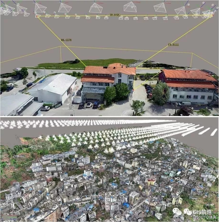
Figure 1 Oblique photography technology
3.1.3 Integration of BIM model and GIS technology
The BIM (Building Information Modeling) model is a digital result of the corresponding engineering entities that is gradually improved and gradually enriched in the process of engineering design, construction and operation. This achievement not only reflects the data production achievements during the entire life cycle of the project, but also uses its own spatial relationship attributes to express the spatial state consistent with the actual engineering entity. The Geographic Information System (Geographic Information System or Geo-Information System, GIS) is sometimes called "geographic information system". It is a specific and very important spatial information system. It is a technical system that collects, stores, manages, calculates, analyzes, displays, and describes relevant geographical distribution data in the space of all or part of the earth's surface (including the atmosphere) with the support of computer hardware and software systems. In essence, one of these two technologies focuses on the spatial relationship between the macro level and the large scene; the other focuses on the mesoscopic and even microscopic angles, and the spatial expression of the engineering objects in a specific geographic scene. The fusion of these two technologies will enable us to solve the problems from large to small, wide and deep through a system. To intuitively reflect the process of land acquisition and demolition management, a set of practical technical solutions is provided. 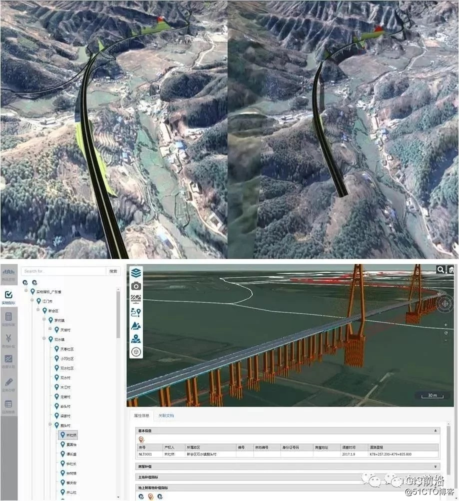
Figure 2 GIS + BIM technology
3.2 The operating environment of the system
hardware is an ordinary PC or notebook. The recommended configuration: 8GB memory / 2.3GHz CPU / 2G unique display / 300GB hard disk. Operating system: Compatible with Win7 / Win10 Office software: Compatible with Microsoft Office 2010 and above;
4. System function
4.1 The physical quantity of land acquisition and house demolition
can easily enter the physical index survey results into the system, and enter the demolition object model or land acquisition vector data in the system Correlate with survey data of physical indicators. The system supports batch import function to realize fast data entry.
The system supports data query through multiple modes such as click and condition screening, as well as export and print. For the query of administrative divisions, it can obtain information such as the area of house requisitioned and demolished, the area of land requisitioned and demolished, and the number of young crops. For personal inquiries, you can find the location of the individual, specific information of physical indicators, detailed investigation reports, photos, etc.
The vector data of GIS expropriation and demolition objects mainly reflect the location, size and spatial topological relationship of the expropriation and demolition objects in geographic space. Use the GIS data production tool to convert the data generated during the detailed investigation of the demolition process to generate vector data that can be displayed in the GIS system, and associate the data with the detailed investigation indicators to ensure that the user clicks on the vector data in the GIS Can accurately find the corresponding detailed information. 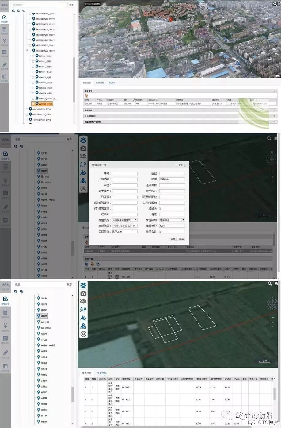
Figure 3 The increase, deletion, modification and inspection of the physical index of land acquisition and house demolition
4.2 The compensation quota standard management is
based on the "Methods for Compiling Investment Estimates for Capital Construction of Highway Engineering" (JTG M20-2011), Guangdong Jiao Ji Han [2006] No. 696 Notice on Improving the Relevant Contents of the Budget Preparation Measures for Highway Capital Construction Projects and the Guangdong Provincial Highway Construction General Headquarters' Notice on Issuing the "Guangdong Provincial Government Repaying Loan Construction Project Land Acquisition and Lump Sum Agreement (Model)", in accordance with land compensation The cost, young crops and forest trees compensation fees, house compensation fees, professional project processing fees, relevant taxes, and other expenses are divided into six parts, and the fixed amount of compensation fees for demolition and demolition is entered according to different local and national regulations to intelligently calculate the demolition costs. Provide data support. 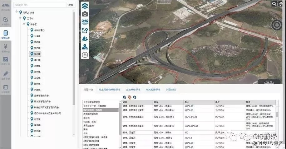
Figure 4 Compensation Quota Standard Management
4.3 Compensation Fees for Land Acquisition and Demolition
According to the data of physical indicators for land acquisition and demolition and the relevant compensation policy stipulations stipulated by the relevant policies of Guangdong Province, Zhongshan City, and Jiangmen City, intelligently calculate the compensation fees for land acquisition and demolition . After the actual compensation amount is confirmed, the actual compensation amount can be manually adjusted to form the final compensation payment data. 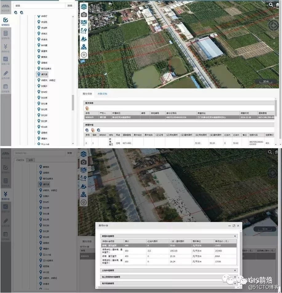
Figure 5 Compensation fees for
land acquisition and house demolition are automatically calculated 4.4 Land acquisition and house demolition plan management
The land acquisition and demolition plan is closely related to the project construction plan. In order to ensure that the project construction starts on time, the land acquisition and demolition process needs to be completed in advance before the project starts. Therefore, the land acquisition and demolition plan can be discharged in accordance with the project construction plan. The system needs to compile the land acquisition and demolition plan according to the project construction pile number, and be able to view the plan. 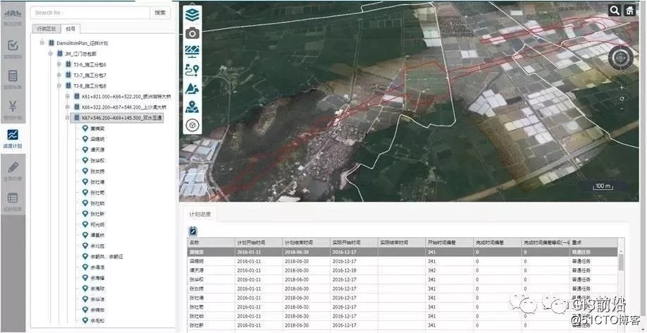
Figure 6 Land acquisition and house demolition plan management
4.5 Land acquisition and house demolition progress management The
whole process of land acquisition and house demolition, including six parts: detailed investigation, evaluation, confirmation of compensation and payment, cost compensation, demolition and land transfer. The responsible unit corresponding to the milestone node of the object of demolition will update the progress of the object of demolition, and report the progress of the demolition in time. 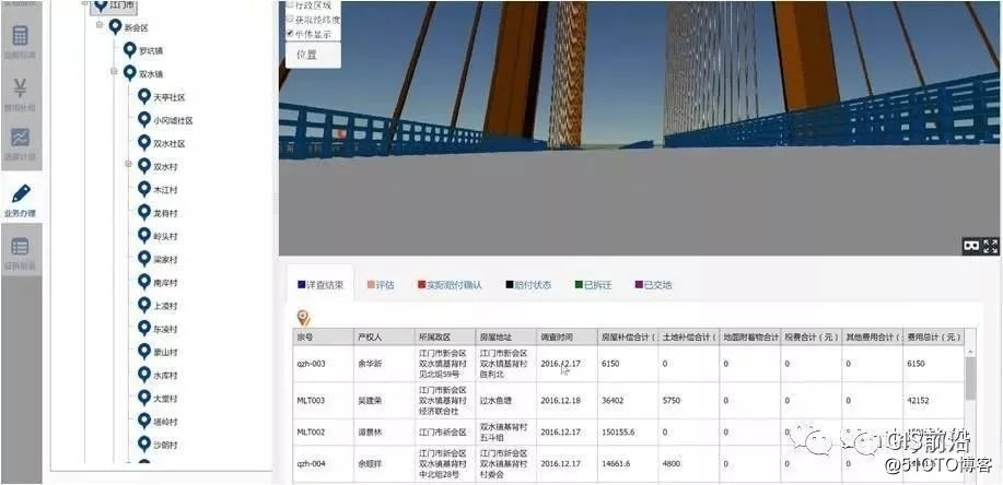
Figure 7 Progress Management of Land Acquisition and Demolition Objects
4.6 Early Warning of Land Acquisition and Demolition Progress Management of the
process of land acquisition and demolition , the main management is the progress of land acquisition and demolition and the cost of land acquisition and demolition. Due to the pair of objects to be demolished in the process of highway demolition, the environment of the demolition site is complex. In order to better manage the requisition and demolition process and progress, the system needs to be able to compare the execution progress according to the demolition plan and provide early warning reminders to the lagging objects. 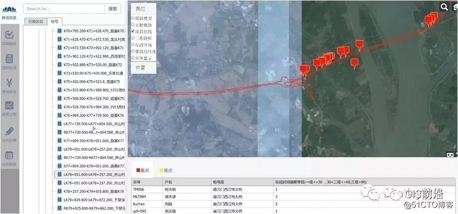
Figure 8 Early warning of land acquisition and demolition progress
4.7 The auxiliary analysis
system for land acquisition and demolition optimization analyzes the relationship between the land acquired in the red line and the object of land acquisition and demolition, and through topology analysis, automatically generates a list of object of land acquisition and demolition that meets the boundary conditions of the preset ratio of demolition. The user can compare the spatial relationship between the project construction object and the demolished object by viewing the demolished objects in the list one by one. Subsequently, the project department can consider using engineering techniques to optimize the design of some projects to achieve the management goal of less or no demolition, and provide support for highway projects to save project demolition costs.
5. Conclusion
system uses three-dimensional GIS technology to realize the organic integration of BIM model and spatial geographic data, which is convenient for visual positioning analysis of scenes and statistical query based on spatial location. Focus on the virtual display of the real scene of the land acquisition and demolition site, the spatial attributes of the object of land acquisition and demolition within the boundary of the engineering survey and measurement boundary, the correlation of the land acquisition and demolition attributes, and the auxiliary calculation of land acquisition and demolition costs.
Surrounding environment simulation. Simulate the surrounding environment of the project, comprehensively simulate the characteristics of the land occupied by the proposed project and the characteristics of ancillary buildings, such as the amount of land, attributes, attachments and other acquisition and demolition indicators to provide technical support for the development of land acquisition and demolition management business; Program optimization. Use the combination of BIM requisition object model and actual project model to comprehensively optimize the land requisition and demolition plan; management of the requisition and demolition process. Use the BIM system to manage the progress of the requisition and relocation in a timely manner, conduct in-depth analysis of the informatization of key objects, and provide data support for the efficient decision-making of the requisition and demolition plan.
Compared with the traditional land acquisition and demolition management methods, the project can significantly improve the management level of the land acquisition and demolition schedule plan through the assistance of the system. Compared with the previous management methods, the project can accurately grasp the progress of each object of land acquisition and demolition, and can give early warning according to the actual construction progress. .
Through the assistance of the system, it is possible to intuitively grasp the relationship between the engineering objects and the objects to be demolished. Through design optimization and construction plan optimization, the purpose of less land acquisition, less demolition, or even no land acquisition or demolition can be achieved. Finally, in order to save the cost of requisition and demolition, provide effective data support.
Application of Management System of Land Requisition and Relocation Based on GIS + BIM Technology
Guess you like
Origin blog.51cto.com/14758767/2487208
Ranking