译自 http://wiki.gis.com/wiki/index.php/Universal_Transverse_Mercator 2020-1-12版,意译。
目录
The Universal Transverse Mercator (UTM) coordinate system is a grid-based method of specifying locations on the surface of the Earth that is a practical application of a 2-dimensional Cartesian coordinate system. It is used to identify locations on the earth, but differs from the traditional method of latitude and longitude in several respects. The UTM system is not a single map projection. The system instead employs a series of sixty zones, each being a six-degree band of longitude, and is based on a specifically defined secant transverse Mercator projection. These zones are wedge shaped on a globe.
通用横轴墨卡托投影(UTM)是一种基于网格,利用2维笛卡尔坐标系,来定位地球表面任意一点的方法。它与传统的利用经纬度的方法在若干方面有所不同。UTM不仅仅是一次投影。UTM将地球沿经度线分割为60个经度带,每一个带横跨6个经度。每一条经度带内的地形地貌都通过横轴墨卡托投影到二维直角坐标系下。每个经度带在地球上都是楔形。
由来
The Universal Transverse Mercator coordinate system was developed by the United States Army Corps of Engineers in the 1940s.The system was based on an ellipsoidal model of the Earth. For areas within the conterminous United States, the Clarke 1866 ellipsoid was used. For the remaining areas of the Earth, including Hawaii, the International Ellipsoid was used. Currently, the WGS84 ellipsoid is used as the underlying model of the Earth in the UTM coordinate system.
通用横轴墨卡托投影由美国军方在上世纪40年代提出。该系统将地球建模为一个椭球体。过去曾利用克拉克1866椭球模型和国际椭球模型。目前采用的是WGS84椭球。
Prior to the development of the Universal Transverse Mercator coordinate system, several European nations demonstrated the utility of grid-based conformal maps by mapping their territory during the interwar period. Calculating the distance between two points on these maps could be performed more easily in the field (using the Pythagorean theorem) than was otherwise possible using the trigonometric formulas required under the graticule-based system of latitude and longitude. In the post-war years, these concepts were extended into the Universal Transverse Mercator / Universal Polar Stereographic (UTM/UPS) coordinate system, which is a global (or universal) system of grid-based maps.
在一战与二战之间,一些欧洲国家已经采用基于网格的保角地图来描绘自身的领土。这些地图将球面投影到了平面上,使得计算地图上两点距离变得更容易(采用勾股定理即可)。二战后,这些想法在UTM/UPS上得到了发展,不仅局限于某个国家,而成为了通用于全球的方法。
The Transverse Mercator projection is a variant of the Mercator projection, which was originally developed by the Flemish geographer and cartographer Gerardus Mercator, in 1569. It is one of the most commonly used projections for rectifying remotely sensed data as well as for large-scale topographic mapping. This projection is conformal, so that it preserves angles and approximate shape but invariably distorts distance and area. UTM involves non-linear scaling in both Eastings and Northings to ensure the projected map of the ellipsoid is conformal.
横向墨卡托投影由墨卡托投影变化而来。后者由16世纪荷兰的地理学家墨卡托提出,今日已经发展成为遥感和测绘领域最常用的投影方法。墨卡托投影具有保角性,球面上的角度投影到平面上,不会发生变化。但是,球面上两点的距离往往会与墨卡托投影后的平面上两点距离不同。
定义
UTM经度带
The UTM system divides the surface of the Earth between 80° S latitude and 84° N latitude into 60 zones, each 6° of longitude in width and centered over a meridian of longitude. Zones are numbered from 1 to 60. Zone 1 is bounded by longitude 180° to 174° W and is centered on the 177th West meridian. Zone numbering increases in an easterly direction.
UTM系统沿着经度线将地球分为60条带,每条带占6度。但UTM系统不适用于北纬84度以北和南纬80度以南(这两块区域适用UPS系统)。条带编号从1到60.第一带的范围从西经174度到180度,中心经线是西经177度。条带编号沿着东方向增加。
Each of the 60 longitude zones in the UTM system is based on a transverse Mercator projection, which is capable of mapping a region of large north-south extent with a low amount of distortion. By using narrow zones of 6° (up to 800 km) in width, and reducing the scale factor along the central meridian by only 0.0004 (to 0.9996, a reduction of 1:2500) the amount of distortion is held below 1 part in 1,000 inside each zone. Distortion of scale increases to 1.0010 at the outer zone boundaries along the equator.
UTM系统的每条经度带都通过横轴墨卡托投影到平面上,所以可以既可以覆盖南北方向上很长的距离,又保证了小的畸变。采用每6度(在地球上,6度的跨度不会超过800km)分割一个经度带,并且将故意将中央经线的比例尺降低万分之四,可以保证任何一条带内的任何一点的比例尺误差都不超过千分之一。仅在每条带的边缘与赤道相交处,比例尺增加千分之一。注,这里的比例尺不是地图到地球的比例尺,而是圆柱表面的图案到圆柱的内切球上对应图案的比例。
In each zone, the scale factor of the central meridian reduces the diameter of the transverse cylinder to produce a secant projection with two standard lines, or lines of true scale, located approximately 180 km on either side of, and approximately parallel to, the central meridian (ArcCos 0.9996 = 1.62° at the Equator). The scale factor is less than 1 inside these lines and greater than 1 outside of these lines, but the overall distortion of scale inside the entire zone is minimized.
由于中央经线上的比例尺被减少了万分之四,而经度带边缘的边界线的比例尺增加了千分之一,所以在两者之间,必然有一条线,其比例尺等于一,称为标准线。考虑到经度带有两条边缘线,所以一条经度带内也就有两条标准线,位于距离中央经线约180km的两侧。由于在投影地图上,这两条线的比例是0.9996,所以两者夹角就是1.62度。
Universal Polar Stereographic coordinate system maps the polar regions and is used in conjunction with the UTM system.
南北极地区采用UPS投影。
重叠网格
Distortion of scale increases in each UTM zone as the boundaries between the UTM zones are approached. However, it is often convenient or necessary to measure a series of locations on a single grid when some are located in two adjacent zones. Around the boundaries of large scale maps (1:100,000 or larger) coordinates for both adjoining UTM zones are usually printed within a minimum distance of 40 km on either side of a zone boundary. Ideally, the coordinates of each position should be measured on the grid for the zone in which they are located, but because the scale factor is still relatively small near zone boundaries, it is possible to overlap measurements into an adjoining zone for some distance when necessary.
在靠近UTM经度带的边界时,比例尺的误差会变得更大。而在地图上测量两个位于不同UTM区域的点的距离时,难免会跨过经度带的边界,引发人们对于误差的担忧。然而,将位于不同的经度带的点放在同一个经度带的直角坐标系下测量毕竟还是方便。理想情况下,每个位置的坐标都应在其所在经度带的坐标系下测量出来。但是考虑到在接近经度带边界时,比例尺的畸变也不大,所以在一个经度带的坐标系下跨带测量两点距离也是可以的。
利与弊
UTM coordinates are easy to use and they work with almost all GPS devices. Also, UTM covers most of the world. The system uses meters as its base unit, which makes conversions and measurements easier. Unfortunately, it is difficult to use UTM if your area of interest covers more than one UTM zone. Therefore, using the UTM coordinate system is not the best choice for mapping extremely large areas. For example, it would not be useful when mapping all of the conterminous United States.
几乎所有的GPS设备都支持UTM坐标。UTM系统覆盖几乎整个地球。它使用米作为单位。但是,如果感兴趣的区域超过一个经度带,UTM的缺点就暴露出来了。所以,在投影非常大的区域时(如美国全境),UTM不是最佳选择。
纬度带
纬度带
Each zone is segmented into 20 latitude bands. Each latitude band is 8 degrees high, and is lettered starting from "C" at 80° S, increasing up the English alphabet until "X", omitting the letters "I" and "O" (because of their similarity to the numerals one and zero). The last latitude band, "X", is extended an extra 4 degrees, so it ends at 84° N latitude, thus covering the northernmost land on Earth. Latitude bands "A" and "B" do exist, as do bands "Y" and Z". They cover the western and eastern sides of the Antarctic and Arctic regions respectively. A convenient mnemonic to remember is that the letter "N" is the first letter in the northern hemisphere, so any letter coming before "N" in the alphabet is in the southern hemisphere, and any letter "N" or after is in the northern hemisphere. While latitude bands are not a part of UTM, they are a part of the Military Grid Reference System (MGRS), which is only used sparingly.
每一个经度带都被分割为20条纬度带。每条纬度带占8度。从南纬80度开始,最南方的纬度带命名为C,随着向北,字母依次增加,直到X,但是跳过I和O(因为它们类似于1和0).最后一条纬度带X的边缘位于北纬84度,确保地球最北端的陆地被包括进来。纬度带A、B、Y、Z其实也存在,它们分别代表南极洲的西部、东部和北冰洋的西部、东部。一个很方便的助记方法是,(从赤道数起)北半球的第一个纬度带是N,恰好也是North的第一个字符。纬度带并属于UTM体系,但它是美军网格参考系的一部分。
标记
The combination of a zone and a latitude band defines a grid zone. The zone is always written first, followed by the latitude band. For example (see image, top right), a position in Toronto, Canada, would find itself in zone 17 and latitude band "T", thus the full grid zone reference is "17T". The grid zones serve to delineate irregular UTM zone boundaries. They also are an integral part of the military grid reference system.
经度带与纬度带的组合定义了一个网格。网格的名称由经度带带号和纬度带带号组成。经度带的带号总是写在网格名的前面,后面是纬度带的带号。比如说,加拿大多伦多位于经度带17,纬度带T,因而组成了网格的编号17T。网格用来描述不规则的UTM带的边界。它们也是美军网格网格参考系的一部分。
A note of caution: A method also is used that simply adds N or S following the zone number to indicate North or South hemisphere (the easting and northing coordinates along with the zone number supplying everything necessary to geolocate a position except which hemisphere). However, this method has caused some confusion since, for instance, "50S" can mean southern hemisphere but also grid zone "50S" in the northern hemisphere。
注意:还有另外一种办法,就是把N(北)或者S(南)放到经度带号之后。但是,这会引起一些误解:50S可以指南半球的50号经度带,也可以指50号经度带+S号纬度带构成的网格(S号纬度带在北半球)。
例外
These grid zones are uniform over the globe, except in two areas. On the southwest coast of Norway, grid zone 32V (9° of longitude in width) is extended further west, and grid zone 31V (3° of longitude in width) is correspondingly shrunk to cover only open water. Also, in the region around Svalbard, the four grid zones 31X (9° of longitude in width), 33X (12° of longitude in width), 35X (12° of longitude in width), and 37X (9° of longitude in width) are extended to cover what would otherwise have been covered by the seven grid zones 31X to 37X. The three grid zones 32X, 34X and 36X are not used.

网格在全球范围内的分布都是均匀的,除去两个地区。网格32V覆盖了整个挪威的西南部,因而跨过了9个经度。其西方的31V随之收缩了3度。另外,在斯瓦尔巴群岛区域,网格31X,33X,35X分别跨过了9度,12度和12度。而32X,34X和36X并未使用。
定位办法
A position on the Earth is referenced in the UTM system by the UTM zone, and the easting and northing coordinate pair. The easting is the projected distance of the position from the central meridian, while the northing is the projected distance of the point from the equator. The point of origin of each UTM zone is the intersection of the equator and the zone's central meridian. In order to avoid dealing with negative numbers a false origin is used. False origins are located south and west of the true origin, and thus create values known as false easting and northing. The central meridian of each zone is given a false easting value of 500,000 meters. Thus, anything west of the central meridian will have an easting less than 500,000 meters. For example, UTM eastings range from 167,000 meters to 833,000 meters at the equator (these ranges narrow towards the poles). In the northern hemisphere, positions are measured northward from the equator, which has an initial "northing" value of 0 meters and a maximum "northing" value of approximately 9,328,000 meters at the 84th parallel — the maximum northern extent of the UTM zones. In the southern hemisphere, northings decrease as you go southward from the equator, which is given a false northing of 10,000,000 meters so that no point within the zone has a negative northing value.
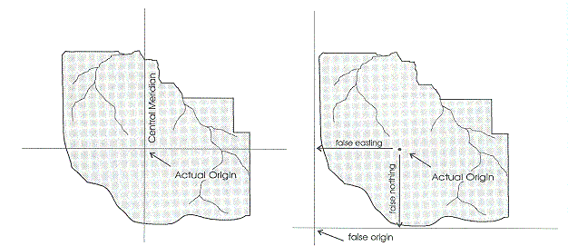
地球上任何一点都可以通过3个量定位:UTM经度带号、东距、北距。东距是该点到中央经线的距离,北距是该点到赤道的距离。每一个UTM经度带的中心都是赤道与中央经线的交点。为了避免中央经线西边的所有点的东距为负值,赤道以南所有点的北距为负值,UTM系统定义了一个伪原点。中央经线的横坐标不再是0,而是500000米。于是,任意一个经度带与赤道的两个交点的横坐标变为了167000(167000 = 500000 -333000)米和833000米(833000 = 500000 + 333000)。北半球任意一点的纵坐标仍然从零0开始(赤道),向北逐渐增加到北纬84度,大约9328000米。在南半球,所有点的纵坐标等于10000000米减该点到赤道的距离,保证所有点的纵坐标大于零。
As an example, the CN Tower is located at the geographic position 43°38′33.24″N 79°23′13.7″W. This is in zone 17, and the grid position is 630084m east, 4833438m north. There are two points on the earth with these coordinates, one in the northern hemisphere and one in the southern. In order to define the position uniquely, one of two conventions is employed:
Append a hemisphere designator to the zone number, "N" or "S", thus "17N 630084 4833438". This supplies the minimum additional information to define the position uniquely.
Supply the grid zone, thus "17T 630084 4833438". The provision of the grid zone supplies redundant information (which may, as a consequence, be contradictory).
Because latitude band "S" is in the northern hemisphere, a designation such as "38S" is ambiguous. The "S" might refer to the latitude band (32N – 40N) or it might mean "South". It is therefore important to specify which convention is being used, e.g., by spelling out the hemisphere, "North" or "South".
举个例子,加拿大国家电视塔位于北纬43°38′33.24″,西经79°23′13.7″。对应经度带17号,东距630084米,北距4833438米。地球上由两个点满足上述描述(经度带17号,东距630084米,北距4833438米),一个在北半球,一个在南半球。为了唯一的定位,可以采用下列方法中的一个:
在经度带号后面添加N或者S:"17N 630084 4833438"
注明网格号:17T 630084 4833438。
S可能带来歧义:可以理解为南半球,也可以理解为纬度带号。为了避免歧义,假如用N/S著名半球,应书写North/South。
