本文为挪威科技大学(作者:Zenebe Hailu Taye)的硕士论文,共86页。
如今,埃塞俄比亚的许多城镇正在迅速发展。在这些快速发展的城镇中,沙舍门可能是最突出的一个。这是因为它的战略地位是沿着古老的长途贸易路线。随着宾馆、饭店、小微企业等行业和服务业的不断增多,城市规模迅速扩大。随着城镇的发展,垃圾的产生量也在增加,特别是固体类的危险废物。不可避免的是,随着城市的快速发展,废物生产和管理问题也随之增加,从而造成了城市中与卫生有关问题的压力。由于不适当的废物管理方法以及有限的公共社区卡车和集装箱,人们被迫在任何空地上处置废物。卫生状况差已成为城市与许多村庄的共同特点。因此,有必要将地理信息系统应用于垃圾填埋场适宜性评价,以解决这一问题,从而有效地管理城市垃圾。虽然该市已经拥有一个固体废物处置场,位于城市西南部,但没有经过科学的选择,也没有在处置场的选择上进行技术应用。
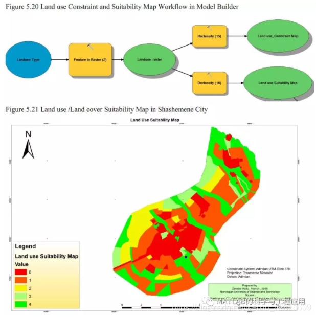
本文采用了土地利用、坡度、路线图、社会服务图、水井和河流数据等因子图。一旦作出了所有必要的安排,就创建了相应的地理数据库,以便在分析过程中保存所有要素类和光栅数据。不同的地质处理工具和空间分析操作都是在为本论文创建的模型生成器中进行。所有因子图都是具有约束的,排列顺序都是从最高到最低的适宜度。根据文献回顾、个人经验以及专家的判断和咨询,对各因子图进行加权。最后,使用空间分析工具中的加权叠加工具,根据权重插入因子图。因此,在沙舍门东南、东北和西南边境地区,非常适宜填埋场的区域覆盖了非常小的面积,约占城市总面积的1.1%,而不适宜的地区覆盖了城市的中心和更广阔的区域,约占全市面积的一半。在城市的大部分中南部和北部区域,那里建有较多的服务设施,不适合垃圾填埋场的发展。
Now a day, many cities and towns aregrowing rapidly in Ethiopia. Among the fast growing towns and cities,Shashemene is probably the prominent one. This is due to its strategic positionlocated along the ancient long distance trade routes. The city is expandingrapidly with increasing number of industries and service sectors such ashotels, restaurants, small and micro enterprises. As town grows, so does theamount of waste production specially the solid hazard waste. It is inevitablethat waste production and management problems increases with rapid urban growthresulting in pressure on sanitary related problems in the city. Because ofImproper waste management practices and limited public and community trucks andcontainers, people are being forced to dispose their wastes in any open fields.Poor sanitary situation has become a common characteristics of many villages inthe city. This necessitates the applications of Geo-information systems onlandfill site suitability assessment as a solution to address the problem andeffectively manage the wastes in the city. Although the city has already onesolid waste disposal site located in South Western part of the city, it notbeen scientifically chosen and no technological applications have been made inselection of the disposal site. Factor maps such as Land use, slope, road map,social service maps, water well and stream data have been used on this thesis.Once all necessary arrangements are made, Geodatabase have been created to holdall feature classes and raster data during the analysis process. DifferentGeoprocessing tools and spatial analysis operation were carried out in a modelbuilder created for this particular thesis. All factor maps having constraintare made restricted and the rest are given a suitability scale from the highestfour to the lowest one suitability scale. The weights, which have been appliedagainst each factor maps, were based on reviewing literatures, personalexperiences and judgement and consultation of experts in the area. Finally, a weightedoverlay tool from spatial analysis tools have been used and factor maps areinserted in accordance of their weighing. As a result, highly suitable areasfor a landfill development cover very small area in southeastern, northeasternand southwestern borders of the city, constituting approximately 1.1% of thetotal area of the city while unsuitable areas cover the central and wider areaof the city of Shashemene, constituting approximately half of the city’s arealcoverage. Most parts of South central and northern parts of the city wherethere exist built up and services facilities are shown as unsuitable for alandfill site development.
- 引言
- 相关文献回顾
- 研究范围描述
- 数据准备与组织
- 数据分析、结果与讨论
- 结论与建议
更多精彩文章请关注公众号:
