最近在工作中遇到了这个一个需求,用户设定地理围栏,后台获取到实时位置信息后通过与围栏比较,判断是否越界等。
这个过程需要用到数据协议为GEOjson,通过查阅资料后,发现python的shapely库可以非常简单的解决这个问题,接下来演示一下我处理这个问题的过程。
测试数据:
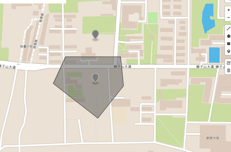
通过http://geojson.io/来获得测试数据,如下图,在地图上绘制了一个多边形设为地理围栏,分别取了围栏内外两个点来进行测试。
得到GEOjson数据如下:
{
  "type": "FeatureCollection",
  "features": [
    {
      "type": "Feature",
      "properties": {},
      "geometry": {
        "type": "Polygon",
        "coordinates": [
          [
            [
              114.3458104133606,
              30.476167529462785
            ],
            [
              114.34512376785278,
              30.475575748963195
            ],
            [
              114.34576749801636,
              30.474540124433936
            ],
            [
              114.3467652797699,
              30.475363076967565
            ],
            [
              114.34693694114685,
              30.476102803645833
            ],
            [
              114.3458104133606,
              30.476167529462785
            ]
          ]
        ]
      }
    },
    {
      "type": "Feature",
      "properties": {},
      "geometry": {
        "type": "Point",
        "coordinates": [
          114.34605717658997,
          30.475584995561178
        ]
      }
    },
    {
      "type": "Feature",
      "properties": {},
      "geometry": {
        "type": "Point",
        "coordinates": [
          114.346604347229,
          30.476518897432545
        ]
      }
    }
  ]
}
安装shapely
本测试基于python——python3.6
$ pip install shapelywindows安装shapely会报错
shapely解析地理围栏
话不多说直接上代码
from shapely.geometry import Point
from shapely.geometry.polygon import Polygon

point = Point(0.5, 0.5)
polygon = Polygon([(0, 0), (0, 1), (1, 1), (1, 0)])
print(polygon.contains(point))
下面是实际的实例:
from shapely.geometry import Point
from shapely.geometry.polygon import Polygon

polygon_data= [
            [
              114.3458104133606,
              30.476167529462785
            ],
            [
              114.34512376785278,
              30.475575748963195
            ],
            [
              114.34576749801636,
              30.474540124433936
            ],
            [
              114.3467652797699,
              30.475363076967565
            ],
            [
              114.34693694114685,
              30.476102803645833
            ],
            [
              114.3458104133606,
              30.476167529462785
            ]
          ]

point1 = Point([114.34605717658997,30.475584995561178])
point2 = Point([114.346604347229,30.476518897432545])
polygon = Polygon(polygon_data)
print(polygon.contains(point1))
print(polygon.contains(point2))
输出结果:
True
False
这样一来我们就快速的实现了,目标点是否在地理围栏内的判断。
总结
Python还是挺好用的:)