简介:
Landsat7_C2_ST数据集是经大气校正后的地表温度数据,属于Collection2的二级数据产品,以开尔文为单位测量地球表面温度,是全球能量平衡研究和水文模拟中的重要地球物理参数。地表温度数据还有助于监测作物和植被健康状况,以及极端高温事件,如自然灾害(如火山爆发、野火)和城市热岛效应。2003年6月以来,因扫描线校正器(SLC)故障导致传输数据存在间隙问题。前言 – 人工智能教程
Landsat 7 C2 ST 数据集是由美国地质调查局(USGS)制作的Landsat 7卫星图像数据集。该数据集包含Landsat 7卫星在传感器故障前后所拍摄的多光谱卫星影像,地球表面覆盖范围为全球。数据集的像元分辨率为30米,影像包含8个波段,其中包括3个红外波段。Landsat 7 C2 ST 数据集可用于监测自然资源、土地覆盖变化、农业、森林管理和城市规划等领域。该数据集是免费提供下载的,可以通过USGS的全球可视化器(GloVis)进行访问。
地球表面温度是指地球表面或地球大气层与表面交界处的温度,其测量单位为摄氏度或华氏度。地球表面温度的变化可以受到多种因素的影响,包括太阳辐射、大气层组成、地表反射率、海洋循环等。近年来,由于人为活动的影响,如大气层中温室气体的增加,地球表面温度呈上升趋势,造成严重的气候变化问题。
波段:
| 名称 | 单位 | 最小值 | 最大值 | 乘法比例因子 | 加性比例因子 | 波长范围(微米) | 描述 |
|---|---|---|---|---|---|---|---|
| B6 | Kelvin | 0 | 65535 | 0.00341802 | 149 | 10.40-12.50 | Band 6 surface temperature. If 'PROCESSING_LEVEL' is set to 'L2SR', this band is fully masked out. |
| ST_ATRAN | Unitless | 0 | 10000 | 0.0001 | Atmospheric Transmittance. If 'PROCESSING_LEVEL' is set to 'L2SR', this band is fully masked out. | ||
| ST_CDIST | km | 0 | 24000 | 0.01 | Pixel distance to cloud. If 'PROCESSING_LEVEL' is set to 'L2SR', this band is fully masked out. | ||
| ST_DRAD | W/(m^2*sr*um)/ DN | 0 | 28000 | 0.001 | Downwelled Radiance. If 'PROCESSING_LEVEL' is set to 'L2SR', this band is fully masked out. | ||
| ST_EMIS | Unitless | 0 | 10000 | 0.0001 | Emissivity estimated from ASTER GED. If 'PROCESSING_LEVEL' is set to 'L2SR', this band is fully masked out. | ||
| ST_EMSD | Unitless | 0 | 10000 | 0.0001 | Emissivity standard deviation. If 'PROCESSING_LEVEL' is set to 'L2SR', this band is fully masked out. | ||
| ST_QA | Kelvin | 0 | 32767 | 0.01 | Uncertainty of the Surface Temperature band. If 'PROCESSING_LEVEL' is set to 'L2SR', this band is fully masked out. | ||
| ST_TRAD | W/(m^2*sr*um)/ DN | 0 | 22000 | 0.001 | Thermal band converted to radiance. If 'PROCESSING_LEVEL' is set to 'L2SR', this band is fully masked out. | ||
| ST_URAD | W/(m^2*sr*um)/ DN | 0 | 28000 | 0.001 | Upwelled Radiance. If 'PROCESSING_LEVEL' is set to 'L2SR', this band is fully masked out. | ||
| QA_PIXEL | Bit Index | 5440 | 16382 | Landsat Collection 2 QA Bitmask | |||
| QA_RADSAT | Bit Index | 0 | 3829 | Radiometric saturation QA |
代码:
/**
 * @File    :   Landsat7_C2_ST_T1
 * @Time    :   2023/03/07
 * @Author  :   GEOVIS Earth Brain
 * @Version :   0.1.0
 * @Contact :   中国(安徽)自由贸易试验区合肥市高新区望江西路900号中安创谷科技园一期A1楼36层
 * @License :   (C)Copyright 中科星图数字地球合肥有限公司 版权所有
 * @Desc    :  数据集key为LANDSAT_7/02/T1/ST的Landsat7_C2_ST类数据集
 * @Name    :   Landsat7_C2_ST_T1数据集
*/

//指定检索数据集,可设置检索的空间和时间范围,以及属性过滤条件(如云量过滤)
var imageCollection = gve.ImageCollection("LANDSAT_7/02/T1/ST")
                    .filterCloud('lt',20)
                    .filterDate('2022-01-20','2022-02-15')
                    .select(['B6'])
                    .limit(10);

print("imageCollection",imageCollection);

//function applyScaleFactors(image) {
//    var thermalBands = image.select('B.*').multiply(0.00341802).add(149.0);
//    return image.addBands(thermalBands, null, true)
//}
//
//var img = imageCollection.map(applyScaleFactors).first();
var img = imageCollection.first();

print("first", img);

var visParams = {
//    gamma: 1,
//    brightness: 1,
    min: 293,
    max: 42199,
    palette: {
    "band_rendering": {
      "pseudocolor": {
      "colormap": [
        '#040274', '#040281', '#0502a3', '#0502b8', '#0502ce', '#0502e6',
        '#0602ff', '#235cb1', '#307ef3', '#269db1', '#30c8e2', '#32d3ef',
        '#3be285', '#3ff38f', '#86e26f', '#3ae237', '#b5e22e', '#d6e21f',
        '#fff705', '#ffd611', '#ffb613', '#ff8b13', '#ff6e08', '#ff500d',
        '#ff0000', '#de0101', '#c21301', '#a71001', '#911003'
        ]
      }
    }
 }
};

Map.centerObject(img);
Map.addLayer(img,visParams);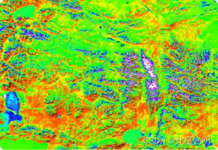
Landsat 数据集属于国际公开数据,可以在没有版权限制的情况下使用、传输或复制。有关USGS数据产品正确引用的更多详细信息,请参阅USGS Visual Identity System Guidancehttps://www.usgs.gov/information-policies-and-instructions/usgs-visual-identity-system