全球土地造型的叶子性状估计
在生物体层面,植物性状是可测量的形态学、解剖学、生理学和物候学特征,可以影响个体的建立、健身和生存。这些可测量的特征为解释全球碳、水、能量通量和生物多样性的长期(如年度)模式提供了基本信息。我们提供了唯一的基于遥感的全球1公里空间分辨率的叶片特征图。特别是,我们提出了特定叶面积(SLA)、叶干物质含量(LDMC)、每干重叶氮含量(LNC)和每干重叶磷含量(LPC)的全球地图。该方法结合了MODIS和Landsat数据、气候学数据(Worldclim)、最大的性状数据库(TRY)和机器学习算法。
下图是我们提供性状估计的方法流程图。编号框表示方法的三个主要部分:(1)填补性状数据库的空白;(2)计算具有附近性状观测数据的MODIS像素在冠层的群落加权平均性状值;(3)将CWMs空间化为500米分辨率的全球性状图。

关于该方法的全部信息可以在这里找到。用户还可以在GEE中使用以下应用程序来探索数据集。
该数据也有两种空间分辨率,3公里和1公里。它可以从这些链接1,2下载。Global Trait Maps with GEE
关于v3的其他信息¶。
3.0版的处理链可以防止外推,并使用更新的分类性状表。为了防止外推,这个更新版本的处理链使用随机森林算法(RF)与代用品来估计性状值。带代用物的随机森林算法允许在输入数据的凸壳内获得模型的集合,以进行预测。此外,使用最新的和更广泛的分类性状表可以增加训练样本量以产生地图。
参考文献
inson, N., Reichstein, M., Bodegom, P. V., Kramer, K., Cornelissen, J. H. C., Reich, P. B.,
Bahn, M., Niinemets, Ü., Peñuelas, J., Craine, J., Cerabolini, B., Minden, V., Laughlin, D. C., Sack, L., Allred, B., Baraloto, C., Byun, C.,
Soudzilovskaia, N. A., Running, S. W. (2018). A methodology to derive global maps of leaf traits using remote sensing and climate data.
Remote Sensing of Environment, 218, 69-88. [doi](https://doi.org/10.1016/j.rse.2018.09.006)
Earth Engine Snippet
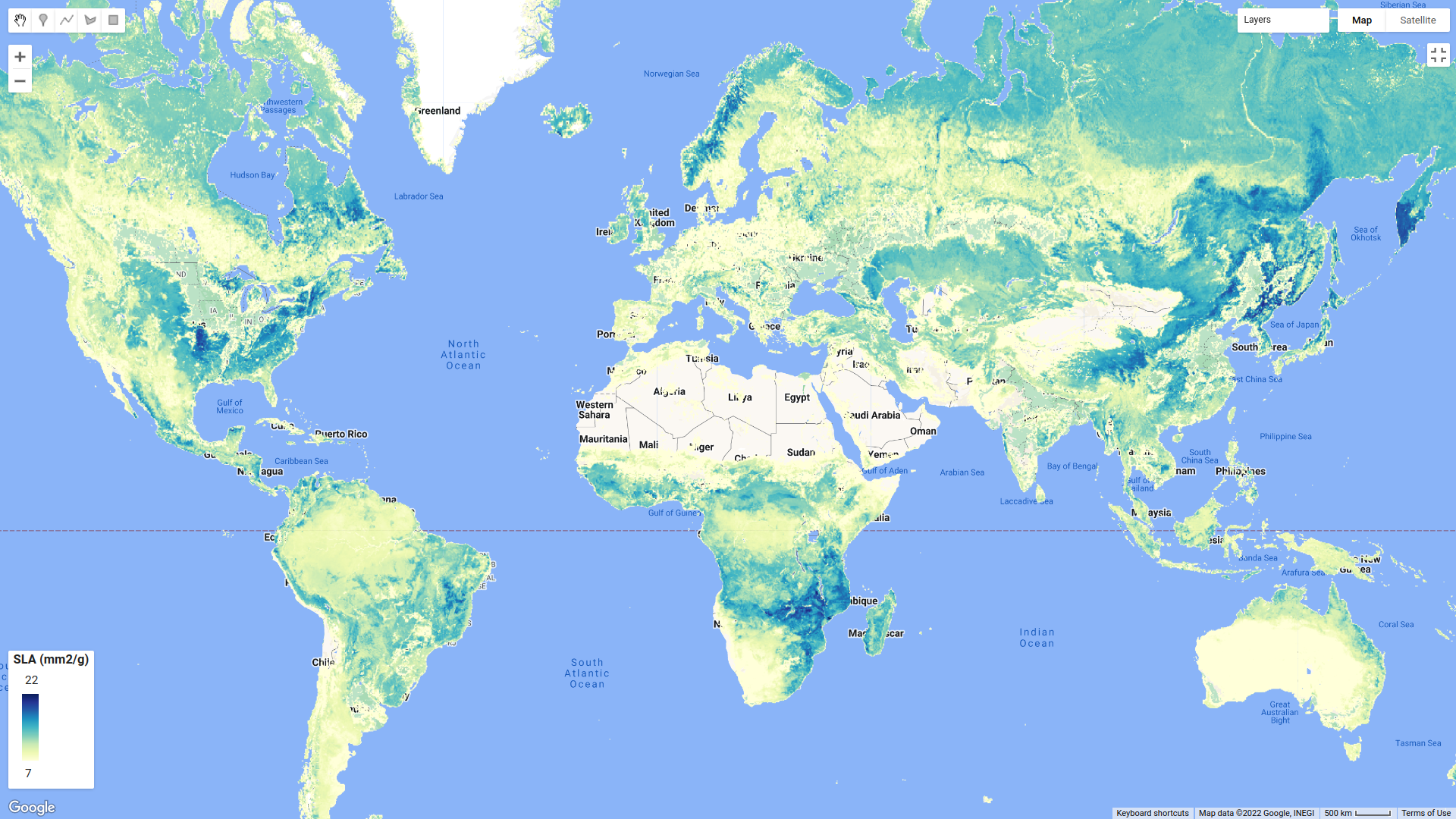
// SLA (mm2/g)
var SLA=ee.Image('projects/sat-io/open-datasets/GLOBAL-LEAF-TRAITS/SLA_1km_v3').select([0],['SLA']);
var SLA_SD = ee.Image('projects/sat-io/open-datasets/GLOBAL-LEAF-TRAITS/SLA_sd_1km_v3').select([0],['SLA_sd']);

// LNC (mg/g)
var LNC=ee.Image('projects/sat-io/open-datasets/GLOBAL-LEAF-TRAITS/LNC_1km_v3').select([0],['LNC']);
var LNC_SD = ee.Image('projects/sat-io/open-datasets/GLOBAL-LEAF-TRAITS/LNC_sd_1km_v3').select([0],['LNC_sd']);

// LPC (mg/g)
var LPC=ee.Image('projects/sat-io/open-datasets/GLOBAL-LEAF-TRAITS/LPC_1km_v3').select([0],['LPC']);
var LPC_SD=ee.Image('projects/sat-io/open-datasets/GLOBAL-LEAF-TRAITS/LPC_sd_1km_v3').select([0],['LPC_sd']);

// Leaf dry matter content LDMC (g/g)
var LDMC=ee.Image('projects/sat-io/open-datasets/GLOBAL-LEAF-TRAITS/LDMC_1km_v3').select([0],['LDMC']);
var LDMC_SD = ee.Image('projects/sat-io/open-datasets/GLOBAL-LEAF-TRAITS/LDMC_sd_1km_v3').select([0],['LDMC_sd']);

//let's mask unprocessed data (Positive values correspond with natural vegetated areas)
SLA = SLA.mask(SLA.gt(0));
LNC = LNC.mask(LNC.gt(0));
LPC = LPC.mask(LPC.gt(0));
LDMC = LDMC.mask(LDMC.gt(0));

var vis_vi = {min:7 , max: 22, palette: ["ffffd9", "edf8b1", "c7e9b4", "7fcdbb", "41b6c4", "1d91c0", "225ea8", "253494", "081d58"]};
Map.addLayer(SLA, vis_vi,  'SLA (mm2 / g)',true)
License
This work is licensed under a Creative Commons Attribution 4.0 International License. You are free to copy and redistribute the material in any medium or format, and to transform and build upon the material for any purpose, even commercially. You must give appropriate credit, provide a link to the license, and indicate if changes were made.
Contact information
If you have any further questions or doubts, please don't hesitate to contact us.
Curated by: Alvaro Moreno-Martínez, Gustau Camps-Valls, Jens Kattge, Nathaniel Robinson, Markus Reichstein, Peter van Bodegom, Josep Peñuelas, Brady Allred, Steve W. Running
Curated copy in GEE by: Samapriya Roy
Keywords: Plant traits, Machine learning, Remote sensing, Plant ecology, Climate, MODIS, Landsat
Last updated: Nov 2021
Last updated in GEE: 2022-12-18