前言
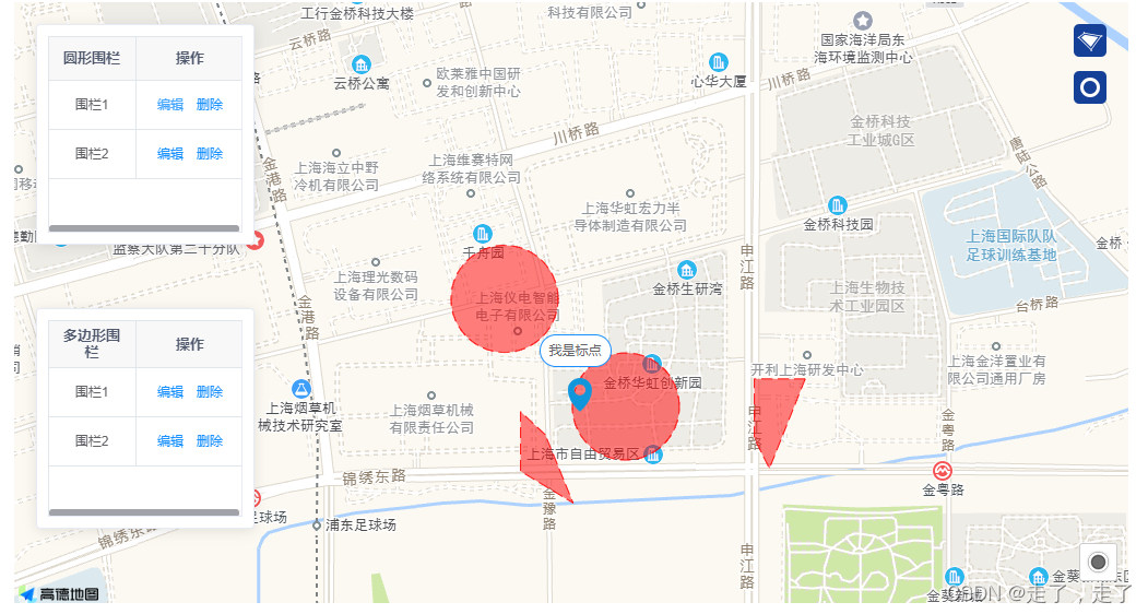
最近又收到了一个需求,需要做地理围栏,要求:地理围栏需要多种类型(圆形,多边形),同时允许存在多个地理围栏,编辑不同的地理围栏,要调整到对应的地理围栏上进行编辑 。于是基于vue-amap 做了如下一个版本的效果:
一、安装vue-amap 并引入
这块网上都有教程,这边就不在过多的叙述的。以下是我找的链接:https://blog.csdn.net/u010227042/article/details/119386501
二、引入遮罩层(圆形和多边形)
代码如下:
<el-amap
        ref="map"
        vid="amapDemo"
        class="amap-box"
        :zoom="zoom"
        :center="center"
        :events="events"
        :map-style="mapStyle"
        :plugin="plugin"
      >
        <!-- 多边形 -->
        <el-amap-polygon
          v-for="(polygon, index) in polygons"
          :key="'polygons'+ index"
          :ref="`polygon_${index}`"
          :vid="index"
          :path="polygon.path"
          :draggable="polygon.draggable"
          stroke-style="dashed"
          stroke-color="#FF0000"
          stroke-weight="1"
          fill-opacity="0.5"
          fill-color="#FF0000"
          :events="polygon.events"
        />
        <!-- 圆形 -->
        <el-amap-circle
          v-for="(circle,index) in circles"
          :key="'circles'+index"
          :ref="`circle_${index}`"
          editable="true"
          :vid="index"
          :center="circle.center"
          :radius="circle.radius"
          fill-opacity="0.5"
          fill-color="#FF0000"
          stroke-style="dashed"
          stroke-color="#FF0000"
          stroke-weight="1"
          :events="circle.events"
        />
        <!-- <el-amap-polyline :editable="polyline.editable" :path="polyline.path" :events="polyline.events" /> -->
 </el-amap>
这里为什么需要写 :ref=“circle_${index}” ?因为在项目中存在多个地理围栏,需要定义唯一值,到时候编辑的时候,才可以获取到你所点击的那个地理围栏。
三.添加多边形和圆形的地理围栏
代码如下(示例):
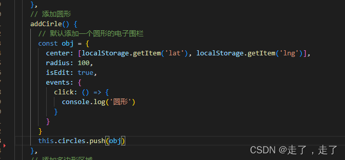
  // 添加圆形
    addCirle() {
      // 默认添加一个圆形的电子围栏
      const obj = {
        center: this.marker.position,
        radius: 100,
        isEdit: true,
        areaName: '默认围栏',
        events: {
          click: () => {
            console.log('圆形')
          }
        }
      }
      this.circles.push(obj)
    },
 ```
```
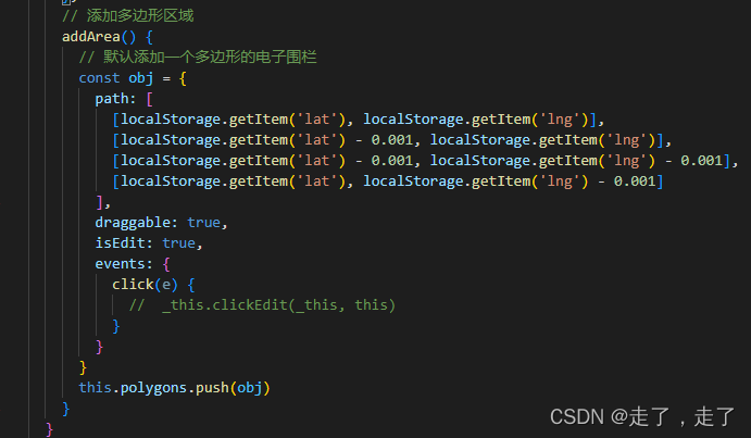
 // 添加多边形区域
    addArea() {
      // 默认添加一个多边形的电子围栏
      const initDate = this.marker.position
      const obj = {
        path: [
          [initDate[0], initDate[1]],
          [initDate[0] - 0.001, initDate[1]],
          [initDate[0] - 0.001, initDate[1] - 0.001],
          [initDate[0], initDate[1] - 0.001]
        ],
        draggable: false,
        areaName: '默认围栏',
        isEdit: true,
        events: {
          click(e) {
            //  _this.clickEdit(_this, this)
          }
        }
      }
      this.polygons.push(obj)
    }
在点击右侧两种类型的图标以后,默认出现圆形的地理围栏或者多边形的地理围栏。
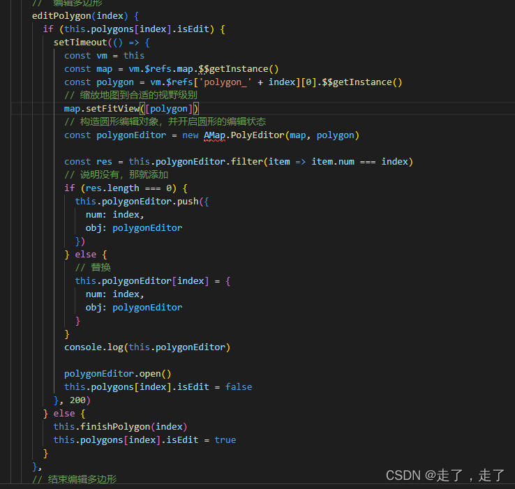
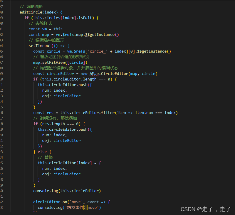
四.编辑圆形和多边形
总结
总体来说,做单个地理位置的难度不大,但一旦涉及到多个不同类型的地理围栏,可能就存在一点难度,但问题也不是很大,只需要多查询一下文档,多动动脑子,也是可以解决的。
如果需要完整的demo 代码,请联系我邮箱:1015095073 @qq.com 微信号:sunyihao1232