国家湿地目录(地表水和湿地)
美国鱼类和野生动物管理局(FWS)是美国联邦的主要机构,负责向公众提供有关我国湿地的状况和趋势的信息。湿地提供了大量的生态、经济和社会效益。它们为鱼类、野生动物和植物提供栖息地--其中许多具有商业或娱乐价值--补充地下水,减少洪水,提供清洁饮用水,提供食物和纤维,并支持文化和娱乐活动。不幸的是,自1780年以来,美国一半以上的湿地已经消失,而且湿地的损失今天仍在继续。这凸显了对湿地范围、类型和变化的地理空间信息的迫切需求。美国FWS国家湿地目录(NWI)是一个公开的资源,提供了关于美国湿地的丰度、特征和分布的详细信息。NWI的数据被美国FWS和全国的自然资源管理者用来促进对湿地的了解、保护和恢复。你可以在这里下载该数据集。Download Seamless Wetlands Data | U.S. Fish & Wildlife Service
数据集和GEE参考前言 – 床长人工智能教程
| Layer Name | GEE_Folder_Prefix | Description |
|---|---|---|
| NWI Historic Wetlands | historic_wetlands | This data set represents the extent and approximate location of historic wetland habitats in certain areas of the conterminous United States |
| NWI Historic Wetlands Project Metadata | hwpm | This data set represents the extent, status, and location of current NWI historic wetland mapping projects. |
| NWI Wetlands | wetlands | This data set represents the extent, approximate location and type of wetlands and deepwater habitats in the United States and its Territories |
| NWI Wetlands Project Metadata | wpm | This data set represents the extent, status, and location of National Wetland Inventory wetland mapping projects for NWI Version 2, Surface Waters and Wetlands |
| NWI Riparian Areas | riparian | This data set represents the extent, approximate location and type of riparian habitats in the western United States. These data delineate the areal extent of riparian habitats as defined by a System For Mapping Riparian Areas in the United States (USFWS 2009) |
| NWI Riparian Project Metadata | rpm | This data set represents the extent, status, and location of current NWI riparian mapping projects |
| NWI Wetlands Historic Map Info | hmi | This data set represents the extent and location of historic wetland map reports generated by the U.S. Fish and Wildlife Service, cooperators, and contractors |
数据预处理
数据集由各州提供,有些州被分割成多个部分。形状文件由多种几何类型组成,包括但不限于点和线绳,以及多边形和多角形。我们试图在earthengine中把每个州的多个部分合并成一个单一的特征集,因为GEE在特征集导出时不会对零面积的对象进行处理,所以我们创建了一个过滤器来标记每个特征类型并计算面积。同时,零面积的特征也被排除在外。目前,湿地数据集是唯一一个应用了这种转换的数据集。
目前,这些湿地文件是完整的,存在于文件夹中,命名为State-Abbreviation_Wetlands,例如佛罗里达州的FL_Wetlands等。其他的数据集并不是所有的州都有,你可以通过简单地在对象上运行earthengine ls或者使用目录来获得资产的清单。由于这是一个巨大的数据集集合,所以没有尝试创建一个全国范围的综合数据。我们还创建了一个单一的JSON文件,让你能够评估哪些数据集包含哪些州,作为一个简单的参考,你可以在这里找到它。Download Seamless Wetlands Data | U.S. Fish & Wildlife Service
Suggested Citation
(dataset) U.S. Fish & Wildlife Service. (2018). National Wetlands Inventory. U.S. Fish & Wildlife Service. https://data.nal.usda.gov/dataset/national-wetlands-inventory. Accessed 2021-09-19.
代码:
The dataset templates underneath can be simply replaced by the state code/territory code to get to the state/region of interest.
var wetlands = ee.FeatureCollection("projects/sat-io/open-datasets/NWI/wetlands/FL_Wetlands");
var historic_wetland = ee.FeatureCollection("projects/sat-io/open-datasets/NWI/historic_wetlands/FL_Historic_Wetlands");
var historic_wetland_project_metadata = ee.FeatureCollection("projects/sat-io/open-datasets/NWI/hwpm/FL_Historic_Wetlands_Project_Metadata");
var historic_map_info = ee.FeatureCollection("projects/sat-io/open-datasets/NWI/hmi/FL_Wetlands_Historic_Map_Info");
var co_riparian = ee.FeatureCollection("projects/sat-io/open-datasets/NWI/riparian/CO_Riparian");
var co_riparian_metadata = ee.FeatureCollection("projects/sat-io/open-datasets/NWI/rpm/CO_Riparian_Project_Metadata");
var wetlands_metadata = ee.FeatureCollection("projects/sat-io/open-datasets/NWI/wpm/FL_Wetlands_Project_Metadata");
var c1 = wetlands.filter(ee.Filter.eq('WETLAND_TY','Freshwater Forested/Shrub Wetland')).map(function(feature){return feature.set('WETLAND_CD',1).copyProperties(feature)})
var c2 = wetlands.filter(ee.Filter.eq('WETLAND_TY','Freshwater Emergent Wetland')).map(function(feature){return feature.set('WETLAND_CD',2).copyProperties(feature)})
var c3 = wetlands.filter(ee.Filter.eq('WETLAND_TY','Freshwater Pond')).map(function(feature){return feature.set('WETLAND_CD',3).copyProperties(feature)})
var c4 = wetlands.filter(ee.Filter.eq('WETLAND_TY','Estuarine and Marine Wetland')).map(function(feature){return feature.set('WETLAND_CD',4).copyProperties(feature)})
var c5 = wetlands.filter(ee.Filter.eq('WETLAND_TY','Riverine')).map(function(feature){return feature.set('WETLAND_CD',5).copyProperties(feature)})
var c6 = wetlands.filter(ee.Filter.eq('WETLAND_TY','Lake')).map(function(feature){return feature.set('WETLAND_CD',6).copyProperties(feature)})
var c7 = wetlands.filter(ee.Filter.eq('WETLAND_TY','Estuarine and Marine Deepwater')).map(function(feature){return feature.set('WETLAND_CD',7).copyProperties(feature)})
var c8 = wetlands.filter(ee.Filter.eq('WETLAND_TY','Other')).map(function(feature){return feature.set('WETLAND_CD',8).copyProperties(feature)})
var empty = ee.Image().byte();
var vis = {min:1, max:8,
palette: ['#008837','#7FC31C','#688CC0','#66C2A5','#0190BF','#13007C','#007C88','#B28653']}
var combined_collection = ee.FeatureCollection([c1,c2,c3,c4,c5,c5,c6,c7,c8]).flatten()
var wetlands_layer = combined_collection.reduceToImage(['WETLAND_CD'], ee.Reducer.mean());
Map.addLayer(wetlands_layer, vis, 'Wetland layer');
// Define a dictionary which will be used to make legend and visualize image on map
var dict = {
"names": [
"Freshwater Forested/Shrub Wetland",
"Freshwater Emergent Wetland",
"Freshwater Pond",
"Estuarine and Marine Wetland",
"Riverine",
"Lake",
"Estuarine and Marine Deepwater",
"Other",
],
"colors": ['#008837','#7FC31C','#688CC0','#66C2A5','#0190BF','#13007C','#007C88','#B28653']};
// Create a panel to hold the legend widget
var legend = ui.Panel({
style: {
position: 'bottom-left',
padding: '8px 15px'
}
});
// Function to generate the legend
function addCategoricalLegend(panel, dict, title) {
// Create and add the legend title.
var legendTitle = ui.Label({
value: title,
style: {
fontWeight: 'bold',
fontSize: '18px',
margin: '0 0 4px 0',
padding: '0'
}
});
panel.add(legendTitle);
var loading = ui.Label('Loading legend...', {margin: '2px 0 4px 0'});
panel.add(loading);
// Creates and styles 1 row of the legend.
var makeRow = function(color, name) {
// Create the label that is actually the colored box.
var colorBox = ui.Label({
style: {
backgroundColor: color,
// Use padding to give the box height and width.
padding: '8px',
margin: '0 0 4px 0'
}
});
// Create the label filled with the description text.
var description = ui.Label({
value: name,
style: {margin: '0 0 4px 6px'}
});
return ui.Panel({
widgets: [colorBox, description],
layout: ui.Panel.Layout.Flow('horizontal')
});
};
// Get the list of palette colors and class names from the image.
var palette = dict['colors'];
var names = dict['names'];
loading.style().set('shown', false);
for (var i = 0; i < names.length; i++) {
panel.add(makeRow(palette[i], names[i]));
}
Map.add(panel);
}
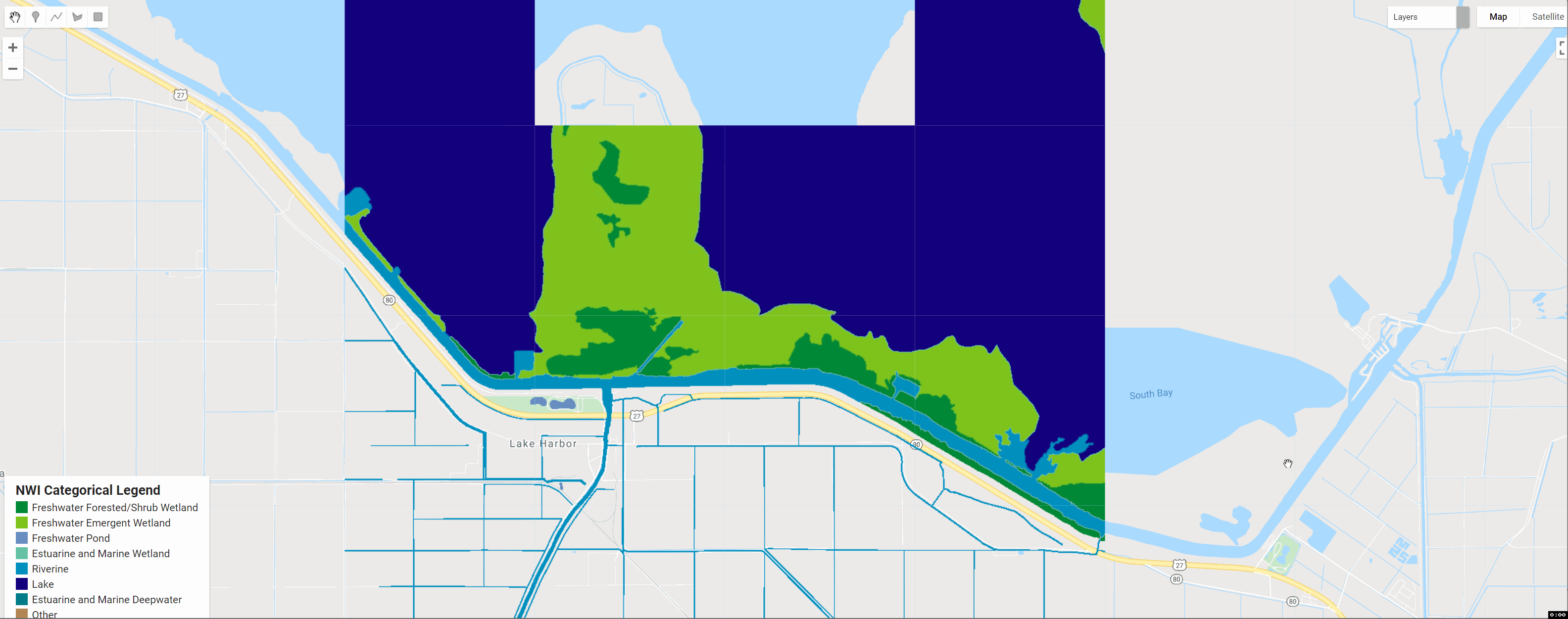
addCategoricalLegend(legend, dict, 'NWI Categorical Legend');代码链接:
图例
湿地类型在湿地制图仪上以类似分类的组别显示(例如,所有淡水萌生的湿地都显示为一个颜色类别)。显示类别如下表所示。为那些希望使用Mapper颜色方案创建自己的地图的人提供了显示颜色代码。
| #008837 | Freshwater- Forested and Shrub wetland |
| #7FC31C | Freshwater Emergent wetland |
| #688CC0 | Freshwater pond |
| #66C2A5 | Estuarine and Marine wetland |
| #0190BF | Riverine |
| #13007C | Lakes |
| #007C88 | Estuarine and Marine Deepwater |
| #B28653 | Other Freshwater wetland |
License
The US FWS National Wetlands Inventory (NWI) is a publicly available resource that provides detailed information on the abundance, characteristics, and distribution of US. NWI datasets are freely available to the public (similar to a CC0 license) and the U.S. Public Domain license.
Created by: U.S. Fish and Wildlife Service
Curated by: Samapriya Roy
Keywords: wetlands, conservation areas, habitats, fish, wildlife, drinking water, recreation, U.S. Fish and Wildlife Service
Last updated: 2021-09-19