遥感图像的裁剪有多种方法,比如按照指定的shapefile图形裁剪,即Arcgis工具箱中的Clip工具。Clip工具在Arcgis工具箱中有两个:一个在分析工具(Analysis Tools->Extract->clip里面),和主要是针对矢量图形的裁剪,而不针对栅格数据;另外一个是在Data Management Tools->Raster->Raster Prossesing->Clip,这个是采用矢量图形或者栅格图形的范围对待裁剪图像进行指定区域的裁剪。
1.工具介绍
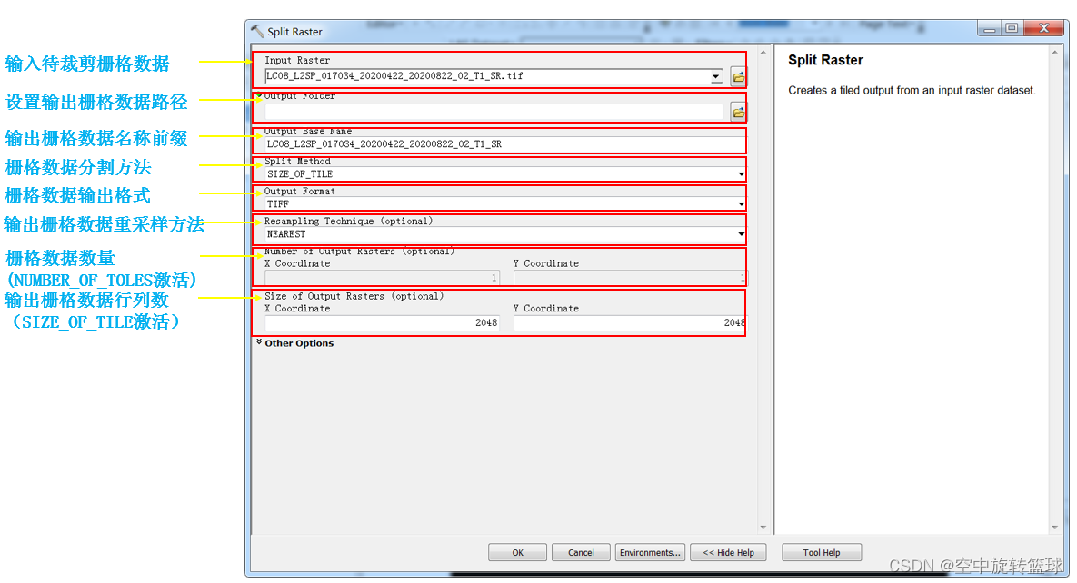
Arcgis中还有一个工具也可以实现对遥感图像的裁剪,这工具就是Split Raster,该工具位于:
Data Management Tools->Raster->Raster Prossesing->Split Raster路径下。
我们打开该工具参数设置窗口,参数的具体解释如下图:
英文参数解释如下:
Input Raster:The input raster dataset to be split into tiles.
Output Folder:The output folder, where the tiles will be created.
Output Base Name:The prefix for each file name. The tile number is then appended to complete the file name, which starts with 0.
By default, the prefix is the same name as the input raster.
Split Method:The tiling method to be used when splitting the raster dataset. It will determine the size and number of tiles for each output dataset.
SIZE_OF_TILE—Allows you to specify the tile width and tile height. Then the appropriate number of tiles will be created. This is the default method. You can also specify a different lower left origin, different output pixel sizes, and the amount of overlap between adjoining tiles (in pixels, meters, feet, degrees, miles, or kilometers).
NUMBER_OF_TILES— Allows you to specify the number of raster tiles to create in the horizontal and the vertical direction. Then the appropriate tile size will be created for each dataset. You can also specify a different lower left origin, different output pixel sizes, and the amount of overlap between adjoining tiles (in pixels, meters, feet, degrees, miles, or kilometers).
Output Format
The file format for the output raster datasets.
TIFF—Tagged Image File Format. This is the default.
BMP—Microsoft Bitmap.
ENVI—ENVI DAT.
Esri BIL—Esri Band Interleaved by Line.
Esri BIP—Esri Band Interleaved by Pixel.
Esri BSQ—Esri Band Sequential.
GIF—Graphic Interchange Format.
GRID—Esri Grid.
IMAGINE IMAGE—ERDAS IMAGINE.
JP2—JPEG 2000.
JPEG—Joint Photographic Experts Group.
PNG—Portable Network Graphics.
Resampling Technique (optional)
Choose the resampling method to use when splitting your raster. The default is bilinear interpolation resampling.
NEAREST—Nearest neighbor assignment
BILINEAR—Bilinear interpolation
CUBIC—Cubic convolution
MAJORITY—Majority resampling
Number of Output Rasters (optional)
Specify the number of tiles in each direction. The default value is 1 tile for each direction.
This option is only valid when the tiling method is NUMBER_OF_TILES.
Size of Output Rasters (optional)
The x and y dimensions of the output tiles. The Units for Output Raster Size
and Overlap parameter will determine the units that are used for these values.
This option is only valid when the tiling method is SIZE_OF_TILE.
The minimum tile size that can be specified it 64 rows by 64 columns.
Overlap (optional)
The number of pixels of overlap between the adjoining tiles. The overlap value will be determined by the Units for Output Raster Size and Overlap parameter.
Units for Output Raster Size and Overlap (optional)
Determines the units that apply to the Size of Output Rasters and the Overlap parameters.
PIXELS—The unit is in pixels. This is the default.
METERS—The unit is in meters.
FEET—The unit is in feet.
DEGREES—The unit is in decimal degrees.
MILES—The unit is in miles.
KILOMETERS—The unit is in kilometers.
Cellsize (optional)
Specify the output pixel size in each direction. By default, the output will match the input raster. If the cell size values are changed, the tile size and count are reset to their default values (image size and 1, respectively).
This parameter is based on the output spatial reference system, which is set in the Environment Settings.
Lower left origin (optional)
The coordinate for the lower left origin point, where the tiling scheme will begin. By default, the lower left origin would be the same as the input raster.
This parameter is based on the output spatial reference system, which is set in the Environment Settings.
这个工具可以实现遥感图像的标准化裁剪。
2.工具应用
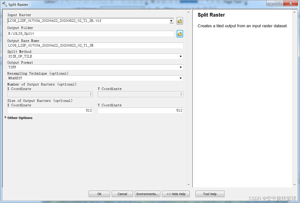
我们采用一景OLI8数据做裁剪分析,看看效果:
打开遥感图像,打开栅格数据分割工具Split Ratser。
设置参数如下,我们将图像分割为512*512标准尺寸大小的小块图像。
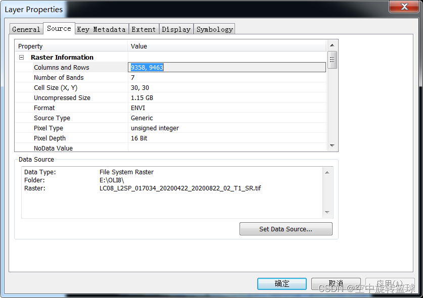
原图像大小是9358*
我们打开栅格分割工具,参数设置如下:
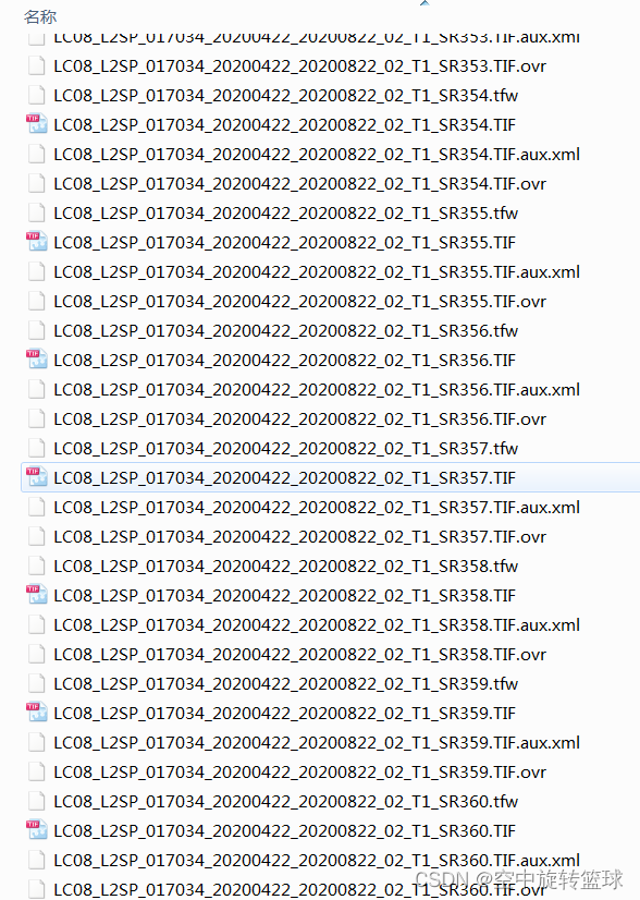
点击OK,裁剪完成之后我们打开输出文件夹路径可以查看到已经裁剪成了361个tif文件,后缀编号从0开始自加1进行编码:
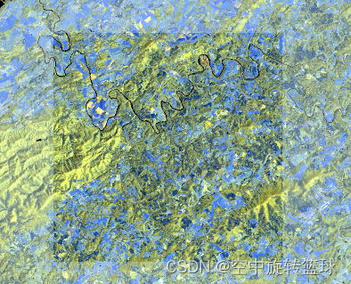
我们随便打开一个tif文件查看其信息,比如打开了104编号的图像,在原图中显示如下,我们打开其属性信息查看数据大小信息:
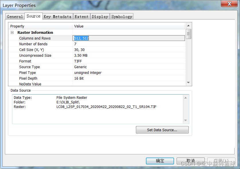
裁剪后的图像大小是512*512像素大小的。
此外,我们还可以修改Split 方法来进行指定行列数的裁剪,即需要将原图像裁剪成多少行和多少列,可以通过修改Split方法,即SIZE_OF_TILE方法改为NUMBER_OF_TILES,然后再后面的行列号数设置参数即可,在此不做赘述。