QML Map中测距
本文转载于:QML QtLocation轻量级地图应用学习:实现测距功能
所有的热爱都要不遗余力,真正喜欢它便给它更高的优先级,和更多的时间吧!
QML其它文章请点击这里: QT QUICK QML 学习笔记
1. 实现思路
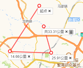
参照百度or高德地图的测距功能,主要由两种元素组成,标记点和连线。
其中连线很好解决,Qt 提供了 MapPolyline 类型,可以用来绘制折线,并且提供了增删的便捷函数:
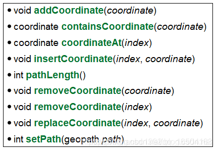
对于标记点,我们可以用 MapQuickItem 来实现,里面包含一个标记圆圈、长度Text、删除按钮。对于一组 MapQuickItem,我使用 MapItemView 来管理。而求两个坐标点的距离,直接调用的 coordinate 类型的 distanceTo 函数,总长直接遍历求距离就行了。
接下来就是封装一个 Ruler 的组件,实现多次测距的绘制。每次开始测距时,通过 createObject 动态创建一个 Ruler 组件,然后往里面添加坐标点。坐标点我是在 Map 上放了一个 MouseArea ,然后用 Map 的 toCoordinate 方法把 point 转换成坐标点。
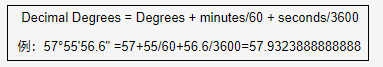
此外,如果要自己计算两点距离,可以参考网上球面两点距离的公式,如:
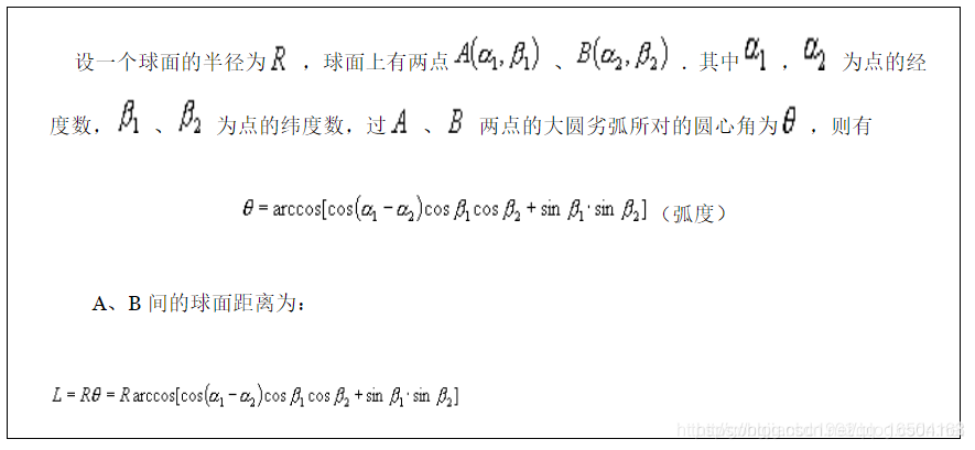
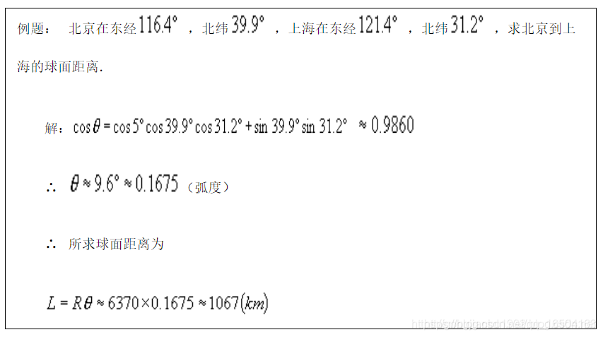
上面参考的表示法应该是十进制的,如果是度分秒的形式,可以先转化下:
2. 实现代码及git链接
下面是实现效果:
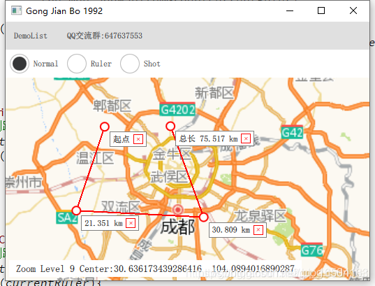
有一点还没解决,那就是 MapPolyline 这种图元设置 layer 实现平滑效果的话,放大之后很卡。另外就是,一个 Ruler 所有元素被删之后我也没有析构它。
Ruler组件的实现代码:
//MapRuler.qml
import QtQuick 2.12
import QtQuick.Controls 2.12
import QtLocation 5.12
import QtPositioning 5.12

// 一次测距里包含多个标记点以及连线
MapItemGroup{


    id: control

    MapPolyline {


        id: item_line
        line.color: "red"
        line.width: 2
        //平滑后放大有点卡
        //layer.enabled: true
        //layer.smooth: true
        //layer.samples: 8
        function getDistanceCount(){


            var distance_count=0;
            for(var i=1;i<pathLength();i++){


                distance_count+=item_line.coordinateAt(i).distanceTo(item_line.coordinateAt(i-1));
            }
            return Math.round(distance_count);
        }
    }

    MapItemView{


        id: item_view
        add: Transition {

    }
        remove: Transition {

    }
        model: ListModel{


            id: item_model
        }
        delegate: MapQuickItem{


            id: ietm_delegate
            sourceItem: Rectangle {


                width: 14
                height: 14
                radius: 7
                color: "white"
                border.width: 2
                border.color: "red"
                Rectangle{


                    anchors.left: parent.right
                    anchors.top: parent.bottom
                    width: item_text.width+5+5+14+5
                    height: item_text.height+10
                    border.color: "gray"
                    Text {


                        id: item_text
                        x: 5
                        anchors.verticalCenter: parent.verticalCenter
                        text: index<=0
                              ? "起点"
                              : (index==item_model.count-1)
                                ? ("总长 "+item_line.getDistanceCount()/1000+" km")
                                :(Math.round(ietm_delegate.coordinate.distanceTo(item_line.coordinateAt(index-1)))/1000+" km")
                    }
                    Rectangle{


                        width: 14
                        height: 14
                        anchors.right: parent.right
                        anchors.rightMargin: 5
                        anchors.verticalCenter: parent.verticalCenter
                        border.color: "red"
                        Text {


                            color: "red"
                            anchors.centerIn: parent
                            text: "+"
                            rotation: 45
                        }
                        MouseArea{


                            anchors.fill: parent
                            onClicked: {


                                //最后一个全部删除,否则一个一个的删除
                                //为0的时候发送信号给group请求删除
                                if(index==item_model.count-1){


                                    item_line.path=[];
                                    item_model.clear();
                                    //control.destroy();
                                }else{


                                    item_line.removeCoordinate(index);
                                    item_model.remove(index);
                                }
                            }
                        }
                    }
                }

                //Component.onDestruction: console.log("destory item");
            }
            //通过listmodel来设置数据
            coordinate{


                latitude: latitudeval
                longitude: longitudeval
            }
            anchorPoint: Qt.point(sourceItem.width/2, sourceItem.height/2)
        }
    }

    function appendPoint(coord){


        //var coord=the_map.toCoordinate(Qt.point(mouseX,mouseY),false);
        //console.log("area",coord.latitude,coord.longitude);
        item_model.append({

    "latitudeval":coord.latitude,"longitudeval":coord.longitude});
        item_line.addCoordinate(coord);
        //mouse_area._closePath=false;
        //console.log("ruler append",item_model.count,item_line.pathLength())
    }

    function followMouse(coord){


        if(item_line.pathLength()<=0)
            return;
        if(item_line.pathLength()===item_model.count){


            item_line.addCoordinate(coord);
        }else{


            item_line.replaceCoordinate(item_line.pathLength()-1,coord);
        }
    }

    function closePath(){


        while(item_line.pathLength()>item_model.count){


            item_line.removeCoordinate(item_line.pathLength()-1);
        }
    }
}
在 Window 中调用下面组件来展示 Demo:
//Demo.qml
import QtQuick 2.12
import QtQuick.Controls 2.12
import QtLocation 5.12
import QtPositioning 5.12
//地图自定义
Item{
id: control
//地图的模式
// 0:普通浏览
// 1:测距
property int mapMode: 0
property MapRuler currentRuler: null
property alias map: the_map
clip: true
onMapModeChanged: {
console.log("map mode",mapMode);
if(control.mapMode!=1&¤tRuler){
currentRuler.closePath();
currentRuler=null;
}
}
//缩放等级,维度,精度
function viewPoint(zoomLevel,latitude,longitude){
the_map.zoomLevel=zoomLevel;
the_map.center=QtPositioning.coordinate(latitude, longitude);
}
Row{
RadioButton{
text: "Normal"
checked: true
onCheckedChanged: if(checked)control.mapMode=0;
}
RadioButton{
text: "Ruler"
onCheckedChanged: if(checked)control.mapMode=1;
}
}
Map {
id: the_map
anchors.fill: parent
anchors.topMargin: 40
minimumZoomLevel: 4
maximumZoomLevel: 16
zoomLevel: 10
center: QtPositioning.coordinate(30.6562, 104.0657)
plugin: Plugin {
name: "esri" //"esri" "mapbox" "osm" "here"
}
//显示缩放等级与center
Rectangle{
anchors{
left: the_map.left
bottom: the_map.bottom
margins: 5
}
width: content.width+20
height: content.height+10
Text {
id: content
x: 10
y: 5
font.pixelSize: 14
text: "Zoom Level "+Math.floor(the_map.zoomLevel)+" Center:"+the_map.center.latitude+" "+the_map.center.longitude
}
}
MouseArea{
id: map_mouse
anchors.fill: parent
enabled: control.mapMode!=0
//画了一个点后跟随鼠标,除非双击
hoverEnabled: true
onClicked: {
// 1 测距
if(control.mapMode===1){
if(!currentRuler){
currentRuler=ruler_comp.createObject(the_map);
if(currentRuler)
the_map.addMapItemGroup(currentRuler);
}
if(currentRuler){
var coord=the_map.toCoordinate(Qt.point(mouseX,mouseY),false);
currentRuler.appendPoint(coord);
}
}
}
onDoubleClicked: {
// 1 测距
if(control.mapMode===1){
if(currentRuler){
currentRuler.closePath();
currentRuler=null;
}
}
}
onPositionChanged: {
// 1 测距
if(control.mapMode===1){
if(currentRuler){
var coord=the_map.toCoordinate(Qt.point(mouseX,mouseY),false);
currentRuler.followMouse(coord);
}
}
}
}
}
Component{
id: ruler_comp
MapRuler{
}
}
}
代码 github 链接:https://github.com/gongjianbo/MyQtLocation