在工作中开发网约车相关功能的时候,需要提供一个通过指定位置查询附近司机的接口。现将研究成果记录下来
1、使用场景
司机在空闲时,会在司机端定时上报其位置。当乘客下单后,会通过乘客的位置查询附近司机然后进行匹配
2、GEO简介
reids在版本 3.2.0之后,引入了geo功能,可用于处理地理位置。涉及到的相关命令有:GEOADD、DEODIST、GEORADIUS等
3、代码示例
pom依赖:
<dependency>
    <groupId>org.springframework.boot</groupId>
    <artifactId>spring-boot-starter-web</artifactId>
</dependency>
<dependency>
    <!-- redis -->
    <groupId>org.springframework.boot</groupId>
    <artifactId>spring-boot-starter-data-redis</artifactId>
</dependency>
GEO工具类:
扫描二维码关注公众号,回复:
10863082 查看本文章

@Service
public class RedisGeoService {

    @Autowired
    private StringRedisTemplate redisTemplate;

    /**
     * 添加经纬度信息
     *
     * redis 命令:geoadd key 116.405285 39.904989 "北京"
     */
    public Long geoAdd(String key, Point point, String member) {
        if (redisTemplate.hasKey(key)) {
            redisTemplate.opsForGeo().remove(key, member);
        }
        return redisTemplate.opsForGeo().add(key, point, member);
    }

    /**
     * 查找指定key的经纬度信息,可以指定多个member,批量返回
     *
     * redis命令:geopos key 北京
     */
    public List<Point> geoGet(String key, String... members) {
        return redisTemplate.opsForGeo().position(key, members);
    }

    /**
     * 返回两个地方的距离,可以指定单位,比如米m,千米km,英里mi,英尺ft
     *
     * redis命令:geodist key 北京 上海
     */
    public Distance geoDist(String key, String member1, String member2, Metric metric) {
        return redisTemplate.opsForGeo().distance(key, member1, member2, metric);
    }

    /**
     * 根据给定的经纬度,返回半径不超过指定距离的元素
     *
     * redis命令:georadius key 116.405285 39.904989 100 km WITHDIST WITHCOORD ASC
     * COUNT 5
     */
    public GeoResults<RedisGeoCommands.GeoLocation<String>> nearByXY(String key, Circle circle, long count) {
        // includeDistance 包含距离
        // includeCoordinates 包含经纬度
        // sortAscending 正序排序
        // limit 限定返回的记录数
        RedisGeoCommands.GeoRadiusCommandArgs args = RedisGeoCommands.GeoRadiusCommandArgs.newGeoRadiusArgs()
                .includeDistance().includeCoordinates().sortAscending().limit(count);
        return redisTemplate.opsForGeo().radius(key, circle, args);
    }

    /**
     * 根据指定的地点查询半径在指定范围内的位置
     *
     * redis命令:georadiusbymember key 北京 100 km WITHDIST WITHCOORD ASC COUNT 5
     */
    public GeoResults<RedisGeoCommands.GeoLocation<String>> nearByPlace(String key, String member, Distance distance,
            long count) {
        // includeDistance 包含距离
        // includeCoordinates 包含经纬度
        // sortAscending 正序排序
        // limit 限定返回的记录数
        RedisGeoCommands.GeoRadiusCommandArgs args = RedisGeoCommands.GeoRadiusCommandArgs.newGeoRadiusArgs()
                .includeDistance().includeCoordinates().sortAscending().limit(count);
        return redisTemplate.opsForGeo().radius(key, member, distance, args);
    }

    /**
     * 返回的是geohash值
     *
     * redis命令:geohash key 北京
     */
    public List<String> geoHash(String key, String member) {
        return redisTemplate.opsForGeo().hash(key, member);
    }

}
建立一个实体,用来封装司机位置信息:
@Getter
@Setter
@Builder
@NoArgsConstructor
@AllArgsConstructor
public class DriverPosition {

    /** 司机id */
    private String driverId;

    /** 城市编码 */
    private String cityCode;

    /** 经度 */
    private double lng;

    /** 纬度 */
    private double lat;

}
建立一个controller,用来做测试:
@RestController
@RequestMapping("redisGeo")
public class RedisGeoController {

    @Autowired
    private RedisGeoService redisGeoService;

    private final String GEO_KEY = "geo_key";

    /**
     * 使用redis+GEO,上报司机位置
     */
    @PostMapping("addDriverPosition")
    public Long addDriverPosition(String cityId, String driverId, Double lng, Double lat) {
        String redisKey = CommonUtil.buildRedisKey(GEO_KEY, cityId);
        Long addnum = redisGeoService.geoAdd(redisKey, new Point(lng, lat), driverId);

        List<Point> points = redisGeoService.geoGet(redisKey, driverId);
        System.out.println("添加位置坐标点:" + points);

        return addnum;
    }

    /**
     * 使用redis+GEO,查询附近司机位置
     */
    @GetMapping("getNearDrivers")
    public List<DriverPosition> getNearDrivers(String cityId, Double lng, Double lat) {
        String redisKey = CommonUtil.buildRedisKey(GEO_KEY, cityId);

        Circle circle = new Circle(lng, lat, Metrics.KILOMETERS.getMultiplier());
        GeoResults<RedisGeoCommands.GeoLocation<String>> results = redisGeoService.nearByXY(redisKey, circle, 5);
        System.out.println("查询附近司机位置:" + results);

        List<DriverPosition> list = new ArrayList<>();
        results.forEach(item -> {
            GeoLocation<String> location = item.getContent();
            Point point = location.getPoint();
            DriverPosition position = DriverPosition.builder().cityCode(cityId).driverId(location.getName())
                    .lng(point.getX()).lat(point.getY()).build();
            list.add(position);
        });

        return list;
    }

}
通过高德地图取点4个位置,所对应的坐标分别是:
东方雨林(114.366386, 30.408199)、怡景江南(114.365281, 30.406869)、梅南山居(114.368049, 30.412896)、武汉大学(114.365248, 30.537860)
其中前三个地址是在一起的,最后一个隔的很远
4、测试
使用postman,分别发送如下请求,添加司机的位置:
http://localhost:18081/redisGeo/addDriverPosition?cityId=420000&driverId=000001&lng=114.366386&lat=30.408199
http://localhost:18081/redisGeo/addDriverPosition?cityId=420000&driverId=000002&lng=114.365281&lat=30.406869
http://localhost:18081/redisGeo/addDriverPosition?cityId=420000&driverId=000003&lng=114.368049&lat=30.412896
http://localhost:18081/redisGeo/addDriverPosition?cityId=420000&driverId=000004&lng=114.365248&lat=30.537860
使用Redis Desktop Manager工具查看刚添加的数据:
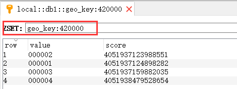
可以看到,保存到redis的数据格式是ZSET,即有序集合。上面的key中包含了城市id,value表示司机id
接下来查询“东方雨林”附近的所有司机位置:http://localhost:18081/redisGeo/getNearDrivers?cityId=420000&lng=114.366386&lat=30.408199
控制台打印日志如下:
GeoResults: [averageDistance: 242.78286666666668 METERS, results: GeoResult [content: RedisGeoCommands.GeoLocation(name=000001, point=Point [x=114.366386, y=30.408199]), distance: 0.0521 METERS, ],GeoResult [content: RedisGeoCommands.GeoLocation(name=000002, point=Point [x=114.365281, y=30.406869]), distance: 182.0457 METERS, ],GeoResult [content: RedisGeoCommands.GeoLocation(name=000003, point=Point [x=114.368049, y=30.412896]), distance: 546.2508 METERS, ]]
上面的结果,包含间隔距离的平均值,附近坐标点经纬度、间隔距离,同时结果是按间隔距离正序排序的
请求返回结果如下:
[
    {
        "driverId": "000001",
        "cityCode": "420000",
        "lng": 114.36638563871384,
        "lat": 30.408199349640434
    },
    {
        "driverId": "000002",
        "cityCode": "420000",
        "lng": 114.3652805685997,
        "lat": 30.406868621031784
    },
    {
        "driverId": "000003",
        "cityCode": "420000",
        "lng": 114.36804860830307,
        "lat": 30.412896187948697
    }
]
再来试下“武汉大学”附近的司机位置,请求返回结果如下:
[
    {
        "driverId": "000004",
        "cityCode": "420000",
        "lng": 114.36524838209152,
        "lat": 30.537860475825262
    }
]