我的GIS 作者:林国佳
一:开发工具与关键技术
1.开发工具 :Visual Stuaio 2015 superMap iDesktop 9D
2.关键技术:Supermap iserver
功能实现(图层管理)

图1
点击图1 勾上医院前的按钮 地图显示医院的位置 如图2,
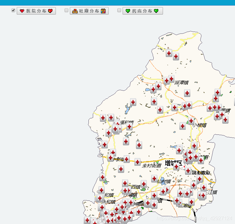
图2
点击医院图标,弹出医院信息 如图3
代码
<html>
<head>
    <meta http-equiv="Content-Type" content="text/html; charset=utf-8" />
    <title>查询交互</title>
    <style type="text/css">
        body {
            margin: 0;
            overflow: hidden;
            background: #fff;
        }

        #MYmap {
            position: relative;
            height: 520px;
            border: 1px solid #3473b7;
        }

        #toolbar {
            position: relative;
            padding-top: 5px;
            padding-bottom: 10px;
        }

    </style>
    <link href="~/bootstrap/css/bootstrap.min.css" rel="stylesheet" />
    <link href="~/bootstrap/css/bootstrap-responsive.css" rel="stylesheet" />
    <script src="~/SuperMap/libs/SuperMap.Include.js"></script>
    @*<script src="~/bootstrap/js/jquery.js"></script>*@
    <script type="text/javascript">
        var MYmap, layer, WDLA, MYtempLayer, MYdrag, MYdelIndex = 0, editEnable = false,
        //设置图层样式
        WDstyle = {
            externalGraphic: "/SuperMap/images/markerbig.png",//externalGraphic用于渲染点的外部图形url。
            graphicWidth: 13,//外部图表的像素宽度。
            graphicHeight: 16,//外部图表的像素高度。
            name: "town"
        },transformControl,
        //host = document.location.toString().match(/file:\/\//) ? "http://localhost:8090" : 'http://' + document.location.host,
        url1 = "http://127.0.0.1:8090/iserver/services/map-zengcheng/rest/maps/增城区_region@ZengCheng";
        function init() {

            //加载map控件
            MYmap = new SuperMap.Map("MYmap", {
                controls: [
                new SuperMap.Control.LayerSwitcher(),//SuperMap.Control.LayerSwitcher 图层选择控件类。
                new SuperMap.Control.ScaleLine(),//比例尺控件
                new SuperMap.Control.Zoom(),//Zoom
                new SuperMap.Control.Navigation({//此控件处理伴随鼠标事件
                    dragPanOptions: {//传给 DragPan 控件的属性
                        enableKinetic: true///设置是否使用拖拽动画。默认为false,不使用动画。
                    }
                })], units: "m"//地图的单位。默认是’degrees’。可选值为’degrees’(或者 ‘dd’), ‘m’,’ft’,’km’,’mi’,’inches’。
            });
            //初始化图层
            layer = new SuperMap.Layer.TiledDynamicRESTLayer("China400", url1, { transparent: true, cacheEnabled: true }, { maxResolution: "auto" });
            layer.events.on({ "layerInitialized": addLayer });
            //初始化Vector图层
            WDLA = new SuperMap.Layer.Vector("医院", { renderers: ["Canvas2"] });//renderers渲染//Vector 创建一个矢量图层。
            //给在vector图层上所选择的要素初始化
            //SelectFeature要素选择控件,该控件实现在指定的的图层上通过鼠标单击和悬浮选择矢量要素。
            //onSelect地物被选中时可以调用该方法,完成用户指定的任务。要求用户定义具体方法, 该方法接收当前选中要素作为参数。
            //onFeatureSelect 方法名
            // 当地物被取消选择时可以调用该方法,完成用户指定的任务。要求用户定义具体方法, 该方法接收地物要素作为参数。
            //onFeatureUnselect 方法名
            //repeat是否重复循环播放。默认为true。
            select = new SuperMap.Control.SelectFeature(WDLA, { onSelect: onFeatureSelect, onUnselect: onFeatureUnselect, repeat: true });
            //添加
            MYmap.addControl(select);
        }

        //要素被选中时调用此函数
        function onFeatureSelect(MYfeature) {

                selectedFeature = MYfeature;
                //popup创建弹窗。在地图上可以打开或关闭,通常情况下点击一个 icon 打开弹窗, 弹窗直接加载到map上,
                //不需要创建图层,可用 SuperMap.Map.addPopup 方法在地图上添加使用。 例如:
                if (MYfeature.popup) {
                    MYfeature.popup.show();//show显示弹窗。覆盖父类方法,显示弹窗。
                    return;
                }
                var contentHTML = "<div style='font-size:.8em; opacity: 0.8; overflow-y:hidden;'>" +
                "<span style='font-weight: bold; font-size: 18px;'>详细信息</span><br>";
                contentHTML += "医院名称:" + MYfeature.attributes["NAME"] + "<br>";
                contentHTML += "医院地址:" + MYfeature.attributes["ADDRESS"] + "<br>";
                contentHTML += "医院电话:" + MYfeature.attributes["TELEPHONE"] + "</div>";

                //popup初始化一个弹出窗口,当某个地图要素被选中时会弹出此窗口,用来显示选中地图要素的属性信息
                MYpopup = new SuperMap.Popup.FramedCloud("chicken",//FranedCloud 具有指向和边框的浮动弹窗。
                //getBounds获得几何图形的边界。如果没有设置边界,可通过计算获得。//getCenterLonLat获取地理格式的范围中心点
                MYfeature.geometry.getBounds().getCenterLonLat(),
                null,
                contentHTML,
                null,
                true,
                null,
                true);
                MYfeature.popup = MYpopup;
                //创建
                MYmap.addPopup(MYpopup);
            }

        //关闭弹出窗口
        function onPopupClose(evt) {
        }
        //清除要素时调用此函数
        function onFeatureUnselect(MYfeature) {
            MYmap.removePopup(MYfeature.popup);
            MYfeature.popup.destroy();
            MYfeature.popup = null;
        }

        //添加图层
        function addLayer() {
            var lonlat = layer.maxExtent.getCenterLonLat();//getCenterLonLat获取地理格式的范围中心点
            lon = lonlat.lon;
            lat = lonlat.lat;
            MYmap.addLayers([layer, WDLA]);
            MYmap.setCenter(new SuperMap.LonLat(lon, lat), 4);
            MYmap.addControl(new SuperMap.Control.MousePosition());

        }

        //SQL查询
        function queryBySQL() {

            WDLA.removeAllFeatures();
            MYdelIndex = 0;

            // 查询中国的部分县。
            var queryParam, queryBySQLParams, queryBySQLService;
            // 初始化查询参数
            queryParam = new SuperMap.REST.FilterParameter({//FilterParameter查询过滤条件参数类。 该类用于设置查询数据集的查询过滤参数。
                name: "P15医疗服务_point@ZengCheng",//图层的名称
                attributeFilter: "TYPE =7200 or TYPE =7280"//查询参数
            }),
            // 初始化sql查询参数
            queryBySQLParams = new SuperMap.REST.QueryBySQLParameters({//QueryBySQLParameters SQL 查询参数类。 该类用于设置 SQL 查询的相关参数。
                queryParams: [queryParam]//查询过滤条件参数数组。
            }),
            // SQL查询服务
            //QueryBySQLService SQL 查询服务类。 在一个或多个指定的图层上查询符合 SQL 条件的空间地物信息。
            queryBySQLService = new SuperMap.REST.QueryBySQLService(url1, {
              //eventListeners监听器对象,在构造函数中设置此参数(可选),对 EditFeaturesService 支持的两个事件 processCompleted 、processFailed 进行监听,相当于调用 SuperMap.Events.on(eventListeners)。
                //
                eventListeners: { "processCompleted": processCompleted, "processFailed": processFailed }
            });
            queryBySQLService.processAsync(queryBySQLParams);
        }

        //SQL查询(县)成功时触发此事件
        function processCompleted(queryEventArgs) {
            //alert(12);
            var i, j, MYfeature,
            result = queryEventArgs.result;
            features = [];
            if (result && result.recordsets) {
                for (i = 0; i < result.recordsets.length; i++) {
                    if (result.recordsets[i].features) {
                        for (j = 0; j < result.recordsets[i].features.length; j++) {
                            MYfeature = result.recordsets[i].features[j];
                            MYfeature.style = WDstyle;
                            features.push(MYfeature);
                        }
                    }
                }
            }

            WDLA.addFeatures(features);
            select.activate();
        }
        //SQL查询(县)失败时出发的事件
        function processFailed(e) {
            //alert(123)
            alert(e.error.errorMsg);
        }

        //清除全部要素
        function clearFeatures() {
            if (WDLA.selectedFeatures.length > 0) {
                MYmap.removePopup(WDLA.selectedFeatures[0].MYopup);
            }
            WDLA.removeAllFeatures();
        }
        function sdf() {
            //alert(document.getElementById("SuperMap.Control.LayerSwitcher_5_input_Vector Layer").checked)
            if (document.getElementById("few").checked) {
                queryBySQL();

            }
            else {
                clearFeatures();
            }
        }

    </script>
</head>
<body "init()">
    <div id="toolbar" >

        <input type="checkbox" value="few" id="few" onclick="sdf()" name="daf"/>
        <span>医院</span>
    </div>
    <div id="MYmap"></div>
</body>
</html>
开发总结
GIS,全称是Geographic Information System,地理信息系统。对我而言就是采集空间有用数据来制作地图的系统 。GIS以地理空间数据基础,由计算机系统、地理数据和用户组成。通过对空间相关是数据进行采集、管理、操作、分析、显示并采用地理模型分析方法,提供各种空间的动态的地理信息,为地理研究和决策服务建立起计算机技术系统。
我一开始学GIS,对GIS的功能不是很了解,supermap iDesktop 9D和superMap iserver软件用的不流畅, 还有功能不会操作,导致花了很多时间去API和百度上去找,去看、去研究。经过一段时间的研究,我做出了上面很简陋的功能。经过研究我积累了一些经验, 通过学习和研究熟悉了软件的常用控件的添加与使用。让我对supermap iDesktop 9D和superMap iserver 有了一点了解,superMap是国产的GIS软件,由北京超图软件股份有限公司研发出来的一款地理信息系统—SuperMap GIS 。