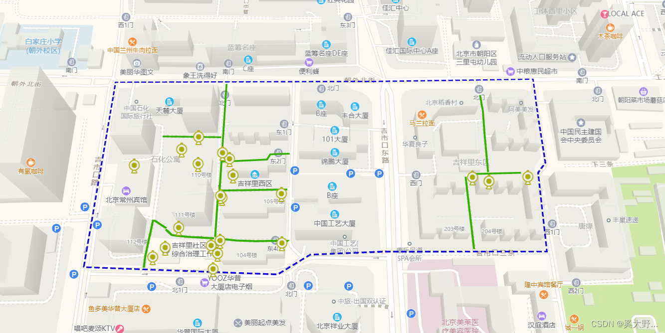
显示围栏 【围栏效果是由多个经纬度点连接起来的】
data(){


	return{


		map:{


				Alldata:{

    },  //所属有数据
				map:null,  //地图实例
				polyArr:[],  //图层覆盖物暂存 [针对区域围栏]
				polyLineArr:[],  //图层覆盖物暂存 [针对消防通道线]
				lopyColor:'#1507e3',  //区域围栏是颜色	 默认
				polyLineColor:'#33b100',   //消防通道线的颜色  默认
			},
	}
}

for(let i=0; i<data.length; i++){


	//重新回显描绘
	_this.openPoly(arr[i]);
}

//绘制围栏
openPoly(data){


	//格式化点数据
	let newArr = _this.lnglatFormat(data)
	var polygon = new AMap.Polygon({


		path: newArr,
		//自定义的围栏颜色
		strokeColor: _this.map.lopyColor,
		strokeOpacity: 1,
		strokeWeight: 3,
		strokeOpacity: 1,
		fillColor: '#1791fc',
		fillOpacity: 0,
		// 线样式还支持 'dashed'
		// strokeStyle: "solid",
		strokeStyle: "dashed",
		// strokeStyle是dashed时有效
		// strokeDasharray: [30,10],
	});
	//将图层压入地图实例中
	_this.map.map.add(polygon);
	//将所有的覆盖物存储起来,清除使用
	_this.map.polyArr.push(polygon);
	//图层覆盖物居中
	_this.map.map.setFitView(polygon);
}

//开启绘制消防通道
openLine(data){


	//开启格式化
	let newArr = _this.lnglatFormat(data)
	//拿到所有的点
	let polyline = new AMap.Polyline({


		path: newArr,
		//线条颜色
		strokeColor: _this.map.polyLineColor,
		strokeOpacity: 1,
		strokeWeight: 4,
		// 折线样式还支持 'dashed'
		strokeStyle: "solid",
		// strokeStyle是dashed时有效
	});
	_this.map.map.add(polyline);
	//将所有的覆盖物存储起来,清除使用
	_this.map.polyLineArr.push(polyline);
},

//开启格式话经纬度
lnglatFormat(data){


	let arr = [];
	for(let i=0; i<data.length; i++){


		let newArr = [];
		newArr.push(data[i].lng)
		newArr.push(data[i].lat)
		arr.push(newArr)
	}
	return arr;
}

//显示设备图表
setTimeout(function(){


 _this.map.map = new AMap.Map('videoMap', {


   zoom: 17,
   pitch: 25,
   viewMode: '3D',
   resizeEnable: true,
   layers: [new AMap.TileLayer.Satellite()],
 })

_this.map.map.addControl(new AMap.MapType({


	defaultType:0 //0代表默认,1代表卫星
}));

 //摄像头设备数据
 // let ddc = marker1.ddc;
 // let dwdl = marker1.dwdl;
 // let hy = marker1.hy;
let ddc = [];
let dwdl = [];
let hy = [];
 let xftd = marker1.xftd;

 //报警设备显示   --中心点设备
 let ddcImgsrc = require('@/assets/gif/12.gif');
 let dwdlImgsrc = require('@/assets/gif/22.gif');
 let hyImgsrc = require('@/assets/gif/32.gif');
 let xftdImgsrc = require('@/assets/gif/42.gif');

 ddc.forEach(item=>{


   if(!item.lng || !item.lat){

    return};
   let marker = new AMap.Marker({


     map:_this.map.map ,
     position:[item.lng,item.lat],
     content: `<div><img class="imgRotate" src="${

      ddcImgsrc}" style="width:30px;height:30px;"/></div>`, //设置文本标注内容
		offset: new AMap.Pixel(-15, -15),  //此处应设为图标尺寸的一半
		title:`${

      item.address}`
	});
	marker.setExtData(item);
	//marker增加的点击事件
	marker.on('click', _this.markerClick);
 });

dwdl.forEach(item=>{


  if(!item.lng || !item.lat){

    return};
  let marker = new AMap.Marker({


    map:_this.map.map ,
    position:[item.lng,item.lat],
    content: `<div><img class="imgRotate" src="${

      dwdlImgsrc}" style="width:30px;height:30px;"/></div>`, //设置文本标注内容
		offset: new AMap.Pixel(-15, -15),  //此处应设为图标尺寸的一半
		title:`${

      item.address}`
	});
	marker.setExtData(item);
	//marker增加的点击事件
	marker.on('click', _this.markerClick);
});

xftd.forEach(item=>{


  if(!item.lng || !item.lat){

    return};
  let marker = new AMap.Marker({


    map:_this.map.map ,
    position:[item.lng,item.lat],
    content: `<div><img class="imgRotate" src="${

      xftdImgsrc}" style="width:30px;height:30px;"/></div>`, //设置文本标注内容
		offset: new AMap.Pixel(-15, -15),  //此处应设为图标尺寸的一半
		title:`${

      item.address}`
	});
	marker.setExtData(item);
	//marker增加的点击事件
	marker.on('click', _this.markerClick);
});

hy.forEach(item=>{


  if(!item.lng || !item.lat){

    return};
  let marker = new AMap.Marker({


    map:_this.map.map ,
    position:[item.lng,item.lat],
    content: `<div><img class="imgRotate" src="${

      hyImgsrc}" style="width:30px;height:30px;"/></div>`, //设置文本标注内容
		offset: new AMap.Pixel(-15, -15),  //此处应设为图标尺寸的一半
		title:`${

      item.address}`
	});
	marker.setExtData(item);
	//marker增加的点击事件
	marker.on('click', _this.markerClick);
});

//marker点显示到视觉页面内
// 第一个参数为空,表明用图上所有覆盖物 setFitview
// 第二个参数为false, 非立即执行
// 第三个参数设置上左下右的空白
_this.map.map .setFitView(null,false,[100,100,100,100]);

});