目录
一、在pom.xml中引入postgis-jdbc相关jar包
背景
之前的一些个人文章介绍了空间数据库,以及Mybatis-Plus快速操作数据库组件,以及空间数据库PostGis的相关介绍。现在基于在空间数据库中已经定义了一张空间表,需要在应用程序中使用Mybatis-Plus来进行空间数据的查询、插入等常规操作。
在OGC标准中,通常空间字段是由Geometry类型来表示。而一般编程语言中是没有这种数据类型的。以java为例,怎么操作这些数据,满足业务需求呢?跟着本文一起来学习吧。
今天介绍基于postgis-jdbc的geometry属性的操作。
一、在pom.xml中引入postgis-jdbc相关jar包
<!-- PostgreSql 驱动包 add by wuzuhu on 2022-08-16 -->
<dependency>
    <groupId>net.postgis</groupId>
	<artifactId>postgis-jdbc</artifactId>
	<version>2.5.0</version>
</dependency>
二、需要自定义Handler类来扩展字段支持。
package com.hngtghy.framework.handler;

import java.sql.CallableStatement;
import java.sql.PreparedStatement;
import java.sql.ResultSet;
import java.sql.SQLException;

import org.apache.ibatis.type.BaseTypeHandler;
import org.apache.ibatis.type.JdbcType;
import org.apache.ibatis.type.MappedTypes;
import org.postgis.Geometry;
import org.postgis.PGgeometry;

@MappedTypes({String.class})
public class PgGeometryTypeHandler extends BaseTypeHandler<String> {

    @Override
    public void setNonNullParameter(PreparedStatement ps, int i, String parameter, JdbcType jdbcType) throws SQLException {
        PGgeometry pGgeometry = new PGgeometry(parameter);
        Geometry geometry = pGgeometry.getGeometry();
        geometry.setSrid(4326);
        ps.setObject(i, pGgeometry);
    }

    @Override
    public String getNullableResult(ResultSet rs, String columnName) throws SQLException {
        String string = rs.getString(columnName);
        return getResult(string);
    }

    @Override
    public String getNullableResult(ResultSet rs, int columnIndex) throws SQLException {
        String string = rs.getString(columnIndex);
        return getResult(string);
    }

    @Override
    public String getNullableResult(CallableStatement cs, int columnIndex) throws SQLException {
        String string = cs.getString(columnIndex);
        return getResult(string);
    }


    private String getResult(String string) throws SQLException {
        PGgeometry pGgeometry = new PGgeometry(string);
        String s = pGgeometry.toString();
        return s.replace("SRID=4326;", "");
    }
}
注意,在getResult()中关于4326坐标系的定义,可以根据需要进行废弃。这里写上为了统一投影坐标系。
三、在数据中创建表,建表语句如下:
create table biz_point_test(
	id int8 primary key,
	name varchar(100),
	geom geometry(Point,4326)
);
四、定义Mybatis-plus实体
package com.hngtghy.project.extend.student.domain;

import com.baomidou.mybatisplus.annotation.TableField;
import com.baomidou.mybatisplus.annotation.TableId;
import com.baomidou.mybatisplus.annotation.TableName;
import com.hngtghy.framework.handler.PgGeometryTypeHandler;

import lombok.AllArgsConstructor;
import lombok.Getter;
import lombok.NoArgsConstructor;
import lombok.Setter;
import lombok.ToString;

@TableName(value ="biz_point_test",autoResultMap = true)
@NoArgsConstructor
@AllArgsConstructor
@Setter
@Getter
@ToString
public class PointTest {

	@TableId
	private Long id;

	private String name;

	@TableField(typeHandler = PgGeometryTypeHandler.class)
	private String geom;

	@TableField(exist=false)
	private String geomJson;
}
提醒:1、在属性上使用@TableField(typeHandler=xxx)来指定对应的类型转换器。2、需要在实体上定义autoResultMap=true。否则配置不一定生效。
五、定义mapper查询器
package com.hngtghy.project.extend.student.mapper;

import org.apache.ibatis.annotations.Param;
import org.apache.ibatis.annotations.Select;

import com.baomidou.mybatisplus.core.mapper.BaseMapper;
import com.hngtghy.project.extend.student.domain.PointTest;

public interface PointTestMapper extends BaseMapper<PointTest>{

	static final String FIND_GEOJSON_SQL="<script>"
			+ "select st_asgeojson(geom) as geomJson from biz_point_test "
			+ "where id = #{id} "
			+ "<if test='null != name'>and p.name like concat('%', #{name}, '%')</if>"
			+ "</script>";
	@Select(FIND_GEOJSON_SQL)
	PointTest findGeoJsonById(@Param("id")Long id,@Param("name")String name);

}
六、定义service业务类
package com.hngtghy.project.extend.student.service.impl;

import java.util.List;

import org.springframework.beans.factory.annotation.Autowired;
import org.springframework.stereotype.Service;

import com.baomidou.mybatisplus.core.conditions.query.QueryWrapper;
import com.baomidou.mybatisplus.extension.service.impl.ServiceImpl;
import com.hngtghy.project.extend.student.domain.PointTest;
import com.hngtghy.project.extend.student.mapper.PointTestMapper;
import com.hngtghy.project.extend.student.service.IPointTestService;

@Service
public class PointTestServcieImpl extends ServiceImpl<PointTestMapper, PointTest> implements IPointTestService{

	@Autowired
	private PointTestMapper pointMapper;

	@Override
	public PointTest selectById(Long id) {
		return pointMapper.selectById(id);
	}

	@Override
	public List<PointTest> selectList(PointTest point) {
		QueryWrapper<PointTest> queryWrapper = new QueryWrapper<PointTest>();
		queryWrapper.select("id,name");
        return this.getBaseMapper().selectList(queryWrapper);
	}

	@Override
	public int insertPointTest(PointTest point) {
		return pointMapper.insert(point);
	}

	@Override
	public int updatePoint(PointTest point) {
		return pointMapper.updateById(point);
	}

	@Override
	public PointTest selectGeomById(Long id) {
		QueryWrapper<PointTest> queryWrapper = new QueryWrapper<PointTest>();
		queryWrapper.select("geom","st_asgeojson(geom) as geomJson");
		queryWrapper.eq("id", id);
        return this.getBaseMapper().selectOne(queryWrapper);
	}

	@Override
	public PointTest findGeoJsonById(Long id) {
		return pointMapper.findGeoJsonById(id, null);
	}

}
这里添加了一个数据库不存在的字段geomJson,会将空间属性转变成geojson字段,方便于前台的如leaflet、openlayers、cesium等组件进行展示。所以使用postgis的st_asgeojson(xxx)进行函数转换。
七、相关方法调用
//1、列表查询List<PointTest> pointList = pointService.selectList(null);System.out.println(pointList);[PointTest(id=1559371184090423297, name=中寨居委会, geom=null, geomJson=null), PointTest(id=2, name=禾滩村, geom=null, geomJson=null), PointTest(id=1559403683801796610, name=中寨居委会, geom=null, geomJson=null)]//2、插入PointTest point = new PointTest();point.setName("中寨居委会");point.setGeom("POINT(109.262605 27.200669)");//POINT(lng,lat) 经度,纬度pointService.insertPointTest(point);//3、查询数据PointTest point = pointService.selectGeomById(1559371184090423297L);PointTest json = pointService.findGeoJsonById(1559371184090423297L);PointTest(id=null, name=null, geom=POINT(109.262605 27.200669), geomJson={"type":"Point","coordinates":[109.262605,27.200669]})PointTest(id=null, name=null, geom=null, geomJson={"type":"Point","coordinates":[109.262605,27.200669]})
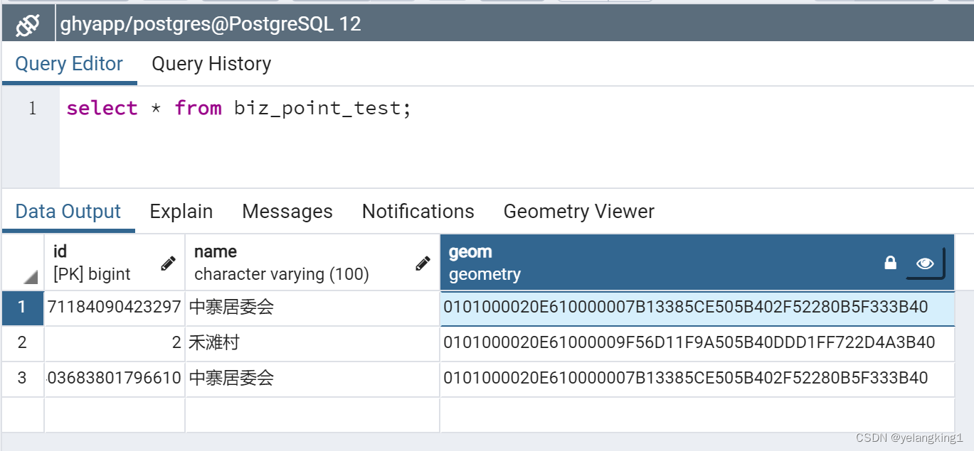
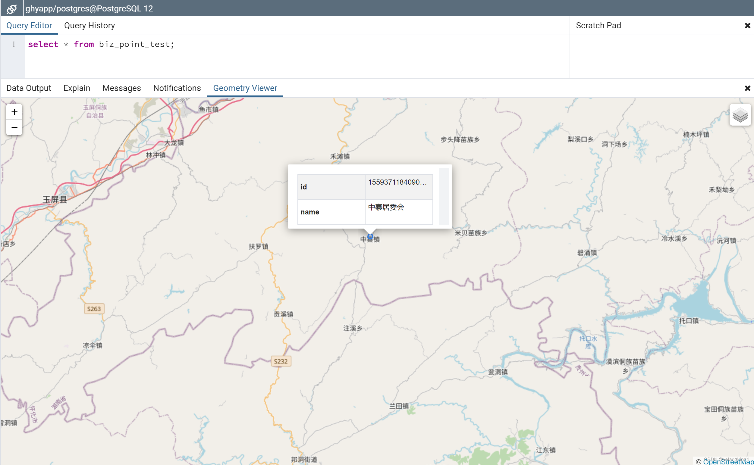
八、使用pgadmin可以查看到相应的点数据,如下图所示:
 总结:通过以上步骤可以实现在mybatis-plus中操作geometry空间字段,同时实现查询和插入操作。通过geojson,结合前端可视化组件即可完成矢量数据的空间可视化。希望本文可以帮到你,欢迎交流。