Tip: After the article is written, the table of contents can be automatically generated. How to generate it can refer to the help document on the right
Article directory
foreword
提示:本篇以SKYLAB北斗多模定位模块,北斗三号定位模块,L1+L5双频北斗模块为切入点:http://www.skylab.com.cn/products-2.html
The Beidou system has been upgraded from navigation and positioning services to spatio-temporal information services, which has continuously spawned new formats of Beidou applications, especially the integration and application of emerging technologies such as 5G, Internet+, and artificial intelligence, and deeply intersects with new infrastructure and sharing economy. In particular, in the creation of digital application scenarios such as smart transportation, smart energy, smart agriculture and water conservancy, smart manufacturing, and smart education, the satellite navigation and location service industry has played an important role in time and space empowerment, accelerating industrial digitalization, and providing The development of my country's digital economy has endowed it with strong vitality.
The construction of modern infrastructure systems represented by new infrastructure, transportation, energy, and water conservancy continues to release demand for Beidou applications, and the digital scenarios formed by the application of Beidou in the fields of smart transportation, smart energy, smart agriculture, water conservancy, and smart manufacturing , is constantly forming new market segments, further expanding the overall market size of my country's satellite navigation and location services.
1. Beidou system overview
The Beidou satellite navigation system (referred to as the Beidou system) is a global satellite navigation system independently developed and operated independently in my country. It provides all-weather, all-time, high-precision positioning, navigation and timing services for global users. The three mature satellite navigation systems are also an important support for the country to implement the "Belt and Road" construction. The Beidou system has also developed a satellite with Chinese characteristics from scratch, from existence to excellence, from active to passive, and from regional to global Navigation system building roads.
At present, the Beidou system provides two categories of navigation and positioning and communication data transmission, as well as seven different services for different regions. The Beidou system provides positioning, navigation and timing services, global short-message communication, and national search and rescue services on a global scale. Among them, passive positioning, navigation, and timing services are all free, while satellite-based augmentation, ground-based augmentation, and precise single-point positioning are provided for the Asia-Pacific region. There are four services for communication with regional short messages.
1.1 Space segment
The nominal space constellation of Beidou-3 consists of 3 geostationary orbit (GEO) satellites, 3 inclined geosynchronous orbit (IGSO) satellites and 24 medium earth orbit (MEO) satellites. GEO satellites orbit at an altitude of 35,786 kilometers, fixed at 80 degrees, 110.5 degrees and 140 degrees east longitude respectively; IGSO satellites orbit at a height of 35,786 kilometers with an orbital inclination of 55 degrees; MEO satellites orbit at an altitude of 21528 kilometers with an orbital inclination of 55 degrees, distributed in Walker24 /3/1 Constellation. The system deploys backup satellites in orbit as appropriate.
1.2 Ground control segment
The ground control section is responsible for the operation control of the system navigation tasks, and is mainly composed of a master control station, a time synchronization/injection station, and a monitoring station.
The main control station is the operation control center of the Beidou system. The main tasks include:
a) Collecting the navigation signal monitoring data of each time synchronization/injection station and monitoring station, performing data processing, generating and injecting navigation messages, etc.; b)
Responsible for mission planning and Scheduling and system operation management and control;
c) Responsible for satellite-ground time observation and comparison;
d) Satellite payload monitoring and abnormal situation analysis, etc.
The time synchronization/injection station is mainly responsible for completing satellite-ground time synchronization measurement and injecting navigation message parameters into satellites.
The monitoring station continuously monitors the satellite navigation signals and provides real-time observation data for the main control station.
1.3 User segment
Various types of Beidou user terminals.
1.4 Coordinate system
The Beidou system uses the Beidou Coordinate System (BDCS). The definition of BDCS conforms to the International Earth Reference System Service (IERS) specification, adopts the reference ellipsoid parameters of the 2000 China Geodetic Coordinate System (CGCS2000), aligns with the latest International Terrestrial Reference Frame (ITRF), and is updated once a year.
The detailed definition of the coordinate system can be found in the Beidou system open service signal interface control document.
1.5 Time system
The time reference of the Beidou system is Beidou Time (BDT). BDT adopts the International System of Units (SI) seconds, no leap seconds, and the starting epoch is January 1, 2006 at 00:00:00 Coordinated Universal Time (UTC). BDT is connected with international UTC through UTC (NTSC), and the deviation between BDT and UTC is kept within 50 nanoseconds (modulo 1 second). Leap second information between BDT and UTC is broadcast in the navigation message.
2. Beidou system positioning, navigation and timing service
The Beidou system has excellent service performance and powerful functions, and can provide a variety of services to meet the diverse needs of users. Among them, three global services including positioning, navigation and timing, international search and rescue, and global short-message communication are provided to global users; four regional services are provided to the Asia-Pacific region, including regional short-message communication, satellite-based augmentation, precise point positioning, and ground-based augmentation .
2.1 Service Overview
The RNSS service is provided through the B1C, B2a, B2b and B1I, B3I signals of the satellites in the Beidou system space constellation, through which users can determine their own position, speed and time. The main performance indicators include space signal accuracy, continuity and availability, positioning, speed measurement, timing accuracy and service availability, etc.
Currently, RNSS services are jointly provided by the Beidou-2 and Beidou-3 constellations.
2.2 Service area
The Beidou system can provide RNSS services to users on the earth's surface and its near-earth area extending to an altitude of 1000 kilometers around the world.
2.3 Beidou signal frequency band
The five spatial signals of RNSS service are:
a) B1C signal: the center frequency is 1575.42MHz, the bandwidth is 32.736MHz, including data component B1C_data and pilot frequency component B1C_pilot. The data component is modulated by binary offset carrier (BOC (1, 1)); the pilot component is modulated by quadrature multiplexing binary offset carrier (QMBOC (6, 1, 4/33)), and the polarization mode is right-handed circular Polarization (RHCP);
b) B2a signal: center frequency is 1176.45MHz, bandwidth is 20.46MHz, contains data component B2a_data and pilot component B2a_pilot, both data component and pilot component adopt binary phase shift keying (BPSK(10) ) modulation, the polarization mode is RHCP;
c) B2b signal: this signal uses the I branch to provide RNSS service, the center frequency is 1207.14MHz, the bandwidth is 20.46MHz, it adopts BPSK (10) modulation, and the polarization mode is RHCP; d
) B1I signal: center frequency is 1561.098MHz, bandwidth is 4.092MHz, adopts BPSK modulation, polarization mode is RHCP;
e) B3I signal: center frequency is 1268.52MHz; bandwidth is 20.46MHz, adopts BPSK modulation, polarization mode is RHCP.
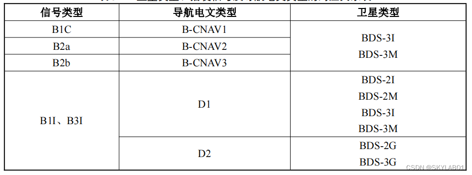
2.4 Beidou navigation message types and information
The navigation message types used by the 5 space signals of RNSS service are:
B1C signal navigation message adopts B-CNAV1 message format, and the navigation information frame format is detailed in BDS-SISICD-B1C-1.0.
The B2a signal navigation message adopts the B-CNAV2 message format, and the navigation information frame format is detailed in the provisions of BDS-SISICD-B2a-1.0.
The B2b signal navigation message adopts the B-CNAV3 message format, and the navigation information frame format is detailed in the provisions of BDS-SISICD-B2b-1.0.
The navigation messages of B1I and B3I signals are divided into D1 message format and D2 message format.
The B1I and B3I signals of all MEO/IGSO satellites broadcast D1 navigation message, and the B1I and B3I signals of all GEO satellites broadcast D2 navigation message.
Refer to the provisions of BDS-SIS-ICD-B1I-3.0 and BDS-SIS-ICD-B3I-1.0 for the format of the navigation information frame in detail.
The navigation message mainly includes:
a) Satellite ephemeris parameters, update period of 1 hour;
b) Satellite clock error parameters, update period of 1 hour;
c) Group delay time correction (TGD), update period of 2 hours;
d) Ionospheric delay correction Parameters, the update period is 2 hours;
e) Satellite health status, updated in real time according to the current status of satellites and space signals;
f) Integrity parameters, updated in real time according to the current status of satellites and space signals;
g) BDT-UTC time synchronization parameters, update period Less than 24 hours;
h) Constellation status (almanac information), the update cycle is less than 7 days.
3. Beidou Navigation System Market Size
The Beidou system has been upgraded from navigation and positioning services to spatio-temporal information services, which has continuously spawned new formats of Beidou applications, especially the integration and application of emerging technologies such as 5G, Internet+, and artificial intelligence, and deeply intersects with new infrastructure and sharing economy. In particular, in the creation of digital application scenarios such as smart transportation, smart energy, smart agriculture and water conservancy, smart manufacturing, and smart education, the satellite navigation and location service industry has played an important role in time and space empowerment, accelerating industrial digitalization, and providing The development of my country's digital economy has endowed it with strong vitality.
Beidou's application market can be divided into three major markets: industry application, mass consumption and special application. There are many application fields in each application market, and specific application scenarios can be refined for each application field.
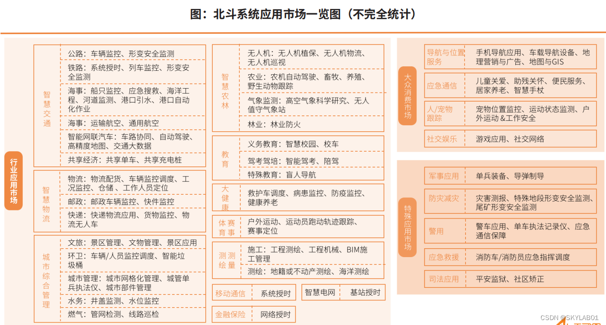
The Beidou system has rich application scenarios in the industrial application market, and because all parties are continuing to promote Beidou applications, the proportion of Beidou applications in some subdivided fields is close to 100%, such as the comprehensive application of Beidou timing signals in the fields of power control and management information , The frequency synchronization backbone network all receives Beidou frequency transmission, and all vehicles in the electric power industry are equipped with Beidou vehicle-mounted terminals. The following will briefly introduce some of the relatively mature and large-scale Beidou system application fields.
3.1. Smart Transportation
As a basic product, the satellite navigation and positioning module is a prerequisite for terminal products to realize positioning and navigation. As one of the largest civilian users of the Beidou system,
the development of the vehicle and ship supervision market is relatively stable. There are more than 7.8 million key operating vehicles installed with Beidou vehicle-mounted terminals nationwide, more than 40,000 postal express vehicles, and more than 47,000
ships . According to the overview of Beidou system applications, in the field of intelligent transportation, the main application scenarios involve highways, railways, maritime affairs, civil aviation, intelligent networked vehicles, etc.
3.2. Smart logistics
In recent years, the scale of China's smart logistics market has grown rapidly. The data shows that in 2020, the scale of China's smart logistics market will reach nearly 600 billion yuan, and in 2021, the scale of China's smart logistics market will reach 647.7 billion yuan, a year-on-year increase of 10.9%. With the further deepening of the integration of the logistics industry and the Internet, the scale of my country's smart logistics market continues to grow. Some research institutions predict that the scale of China's smart logistics market will reach 790.3 billion yuan in 2023.
In the field of smart logistics, Beidou plays an indispensable and important role. At present, it is mainly used in logistics distribution, vehicle scheduling and monitoring, express delivery monitoring, logistics unmanned vehicles, etc. Many logistics companies have adopted Beidou terminal equipment. Beidou and the logistics industry The integration of smart logistics has accelerated the pace of building smart logistics.
Through the real-time monitoring of vehicle speed and route, driving safety is ensured; combined with the geographical location data of the Beidou system, data analysis and mining are carried out to customize the location information of warehouses and sites that urgently need door-to-door delivery, customize service lines, improve logistics efficiency, and control The cost also makes the information more transparent, allowing buyers who view logistics information to see the most convenient delivery route. In addition, some e-commerce platforms have also begun to use Beidou to make logistics more intelligent. Domestic e-commerce platforms have also developed Beidou products such as Beidou smart vehicle terminals and personnel-worn wristbands. According to preliminary estimates, more than 10,000 traditional businesses Enterprises, small and medium-sized enterprises, and logistics companies have enjoyed the e-commerce logistics experience based on Beidou navigation technology. Applying Beidou satellite navigation technology to smart logistics will make transportation information transparent, digital, and traceable, help managers make more scientific and efficient decisions, maximize vehicle utilization rates and control operating costs, and greatly promote The development and construction of smart transportation, smart city and smart life.
3.3 Comprehensive urban management
The scope of urban comprehensive management is relatively broad, generally including city appearance management, environmental sanitation management, "two violations" treatment, muck control, case handling, scenic spot management and other types of needs. The application of the Beidou system in urban comprehensive management involves scenes related to scenic spot management and cultural relics management in cultural tourism, vehicle/personnel monitoring and mobilization in sanitation, and other municipal management. At present, with the rapid development of mobile location services, smart city construction, and Internet of Things construction, Beidou system is embracing urban construction with a more open and integrated attitude. The requirements of high precision, large coverage, high real-time, high reliability, low cost, and scalability of the environment will eventually realize the mature application of a real smart city.
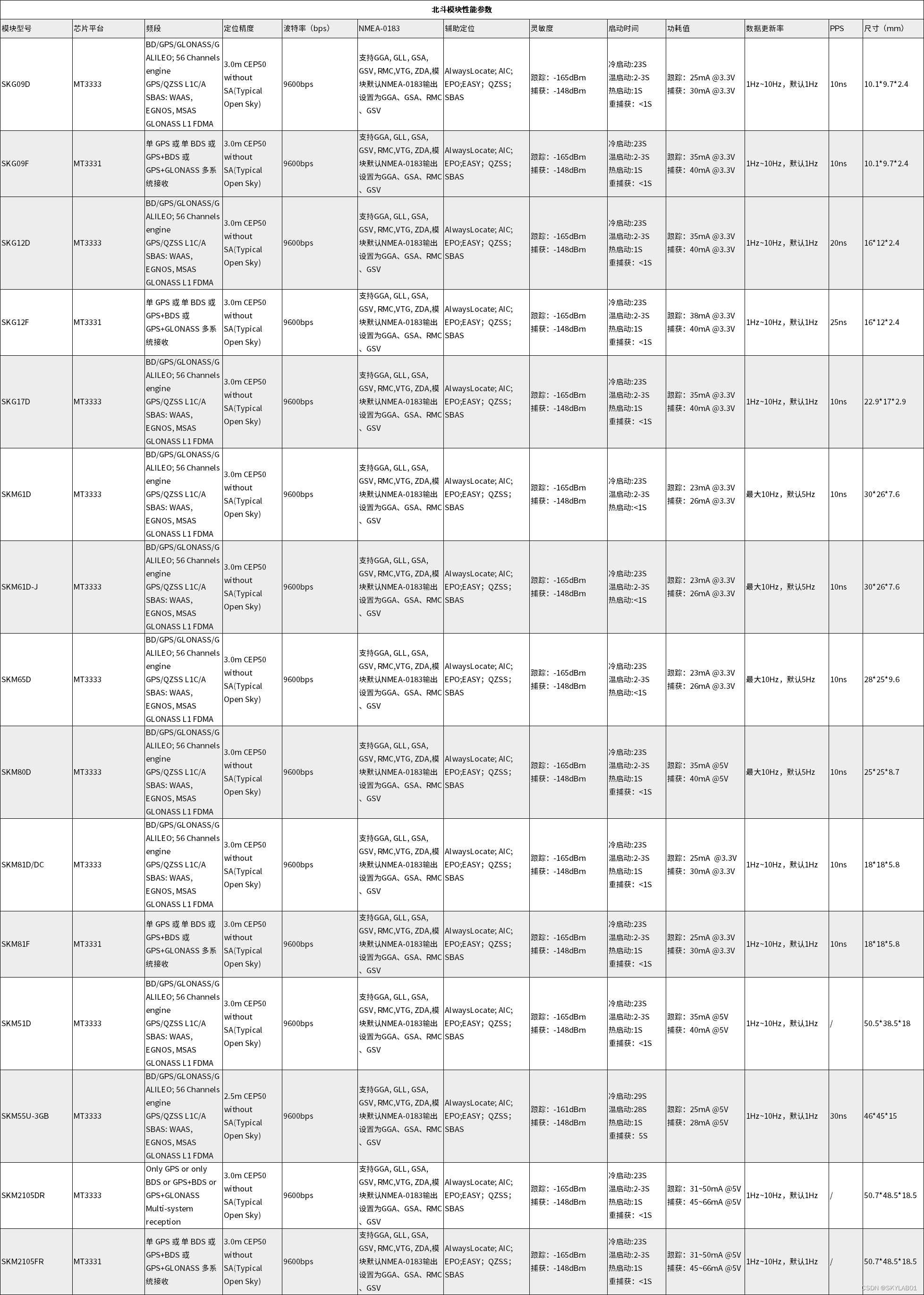
4. Beidou module - Beidou No. 2 module, Beidou No. 3 module
SKYLAB has launched a series of high-quality multi-system GNSS modules for automotive, industrial control and consumer applications, with high positioning accuracy, ultra-low power consumption, small size, and supports multi-system joint positioning and single-system independent positioning. The internal Flash of this series of modules can be upgraded to support different applications. It has an additional front-end LNA to optimize RF performance, easy to integrate with the antenna, and the front-end SAW filter strengthens the anti-interference performance.
Working temperature: -40~85℃
Working voltage: 3.3V
Sensitivity: -165/-148dBm
Positioning accuracy: 2-3m
Speed accuracy: 0.1m/s
Maximum update rate: 10Hz, default 1Hz
Data format: NMEA 0183 Customizable
communication interface : UART
antenna type: support passive and active antennas
Applications: positioning system LBS, car navigation, driving recorder, law enforcement instrument, high-definition camera, surveying and mapping, handheld devices, smart agriculture, etc.

4.1. Beidou-2 positioning module
The Beidou-2 positioning module refers to an industrial-grade standard high-performance navigation and positioning module developed based on the Beidou-2 chip solution, which supports Beidou-2 satellite reception, and the positioning range covers the whole world, making positioning faster and more accurate. Performance is more reliable.
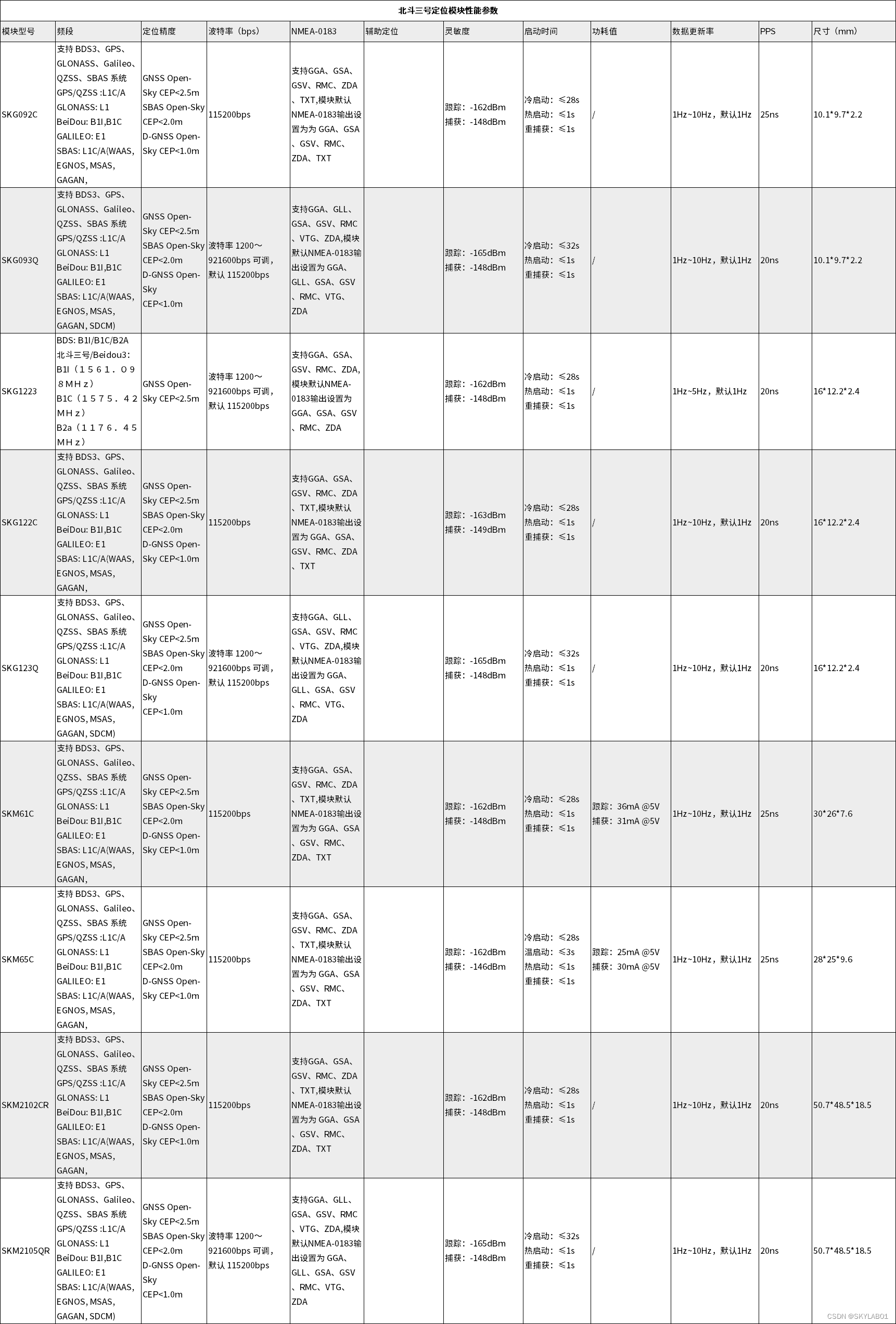
4.2. Beidou-3 positioning module
The Beidou-3 positioning module refers to an industrial-grade standard high-performance navigation and positioning module developed based on the Beidou-3 chip solution. It supports Beidou-2 and Beidou-3 satellite reception. The positioning range covers the whole world, making positioning faster and more accurate. Higher, more reliable product performance.
Summarize
Today, when the technology is quite mature, the success of location-based services is no longer simply a product of competition. In addition, based on the fragmentation characteristics of the Internet of Things, the market increasingly needs closed-loop solutions from data collection, transmission, analysis, decision-making and execution. Therefore, in the direction of enriching the product line, it is more necessary to focus on scenarios and expand around scenarios. Therefore, whether a feasible "scenario-based solution" can be created to achieve commercial implementation is reflected not only in the technology accumulation of a company, but also in its integration and service capabilities.