1. China Beidou Satellite Navigation System-BDS
The Beidou satellite navigation system (referred to as the Beidou system) is a global satellite navigation system independently developed and operated independently in my country. It provides all-weather, all-time, high-precision positioning, navigation and timing services for global users. The three mature satellite navigation systems are also an important support for the country to implement the "Belt and Road" construction. The Beidou system has also developed a satellite with Chinese characteristics from scratch, from existence to excellence, from active to passive, and from regional to global Navigation system building roads.

China's Beidou satellite navigation system "three-step" development plan
In the first step, the Beidou satellite navigation test system was built in 2000, making China the third country in the world to have an independent satellite navigation system.
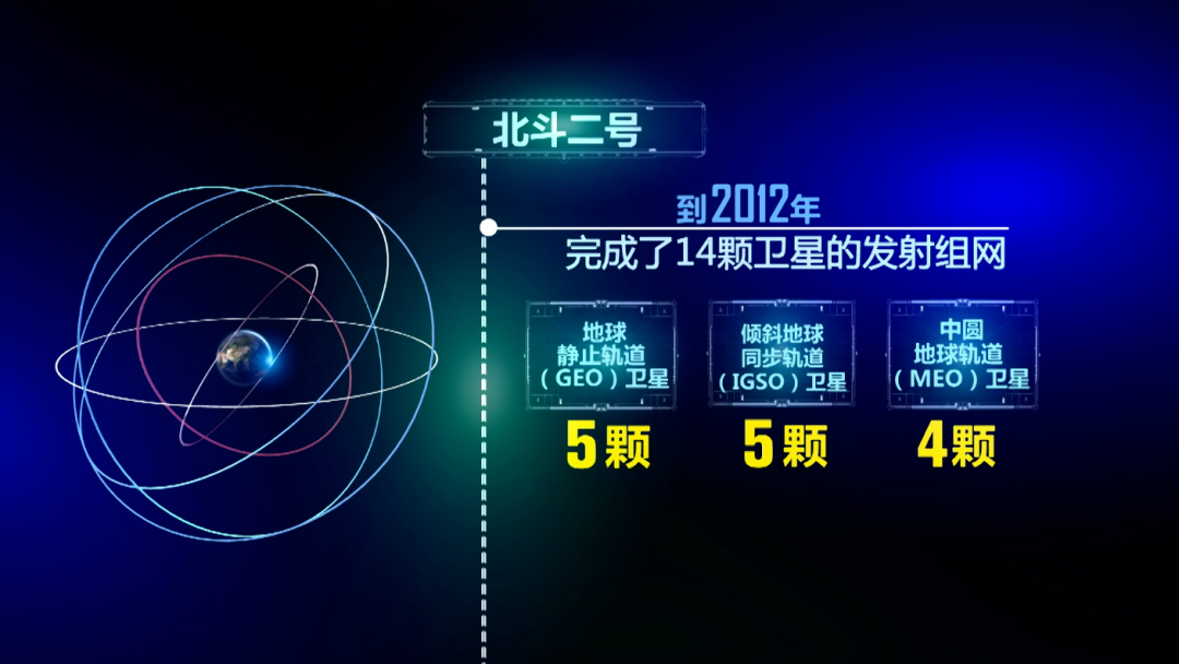
The second step is to build the Beidou satellite navigation system, which will form a service capability covering most of the Asia-Pacific region in 2012.
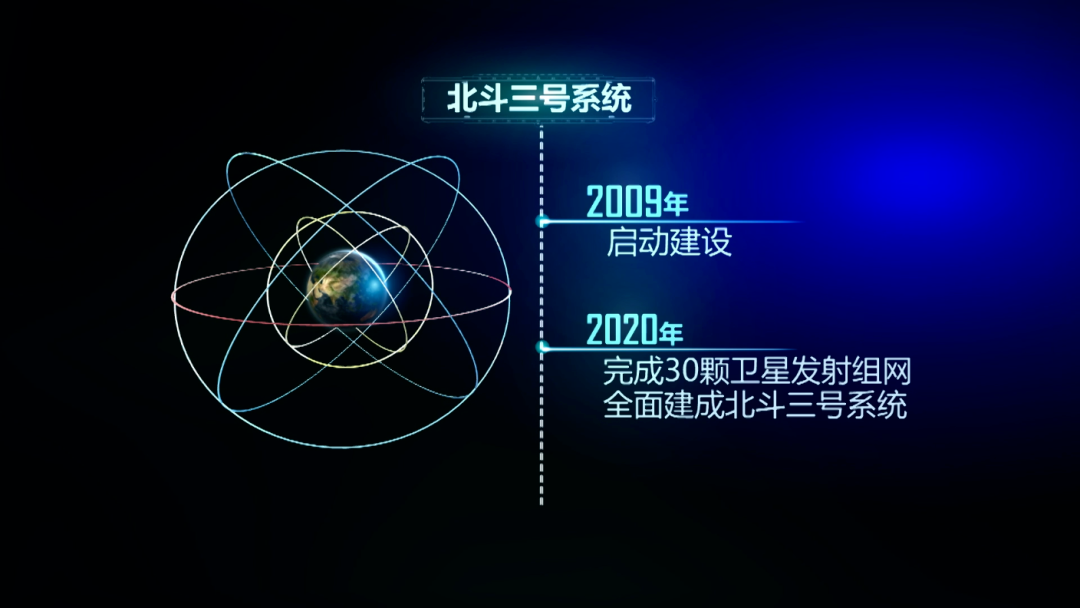
The third step is that the Beidou satellite navigation system has formed a global coverage capability in 2020.
2. Composition of the Beidou system

The Beidou satellite navigation system consists of three parts: the space segment, the ground segment and the user segment. The space segment includes 5 geostationary orbit satellites and 30 non-geostationary orbit satellites.
Geostationary orbit satellites are located at 58.75 degrees, 80 degrees, 110.5 degrees, 140 degrees and 160 degrees east longitude respectively. The non-geostationary orbit satellites are composed of 27 medium-circular orbit satellites and 3 inclined synchronous orbit satellites.
The Beidou system is a mixed navigation constellation composed of three orbiting satellites: GEO satellites, IGSO satellites and MEO satellites. According to the characteristics of Beidou Navigation's "three-step" strategy, through careful deduction and careful calculation, for the first time in the world, geostationary orbit satellites (GEO) and inclined geosynchronous orbit satellites (IGSO) at a distance of 36,000 kilometers from the earth were used in Satellite navigation, designed the world's first "GEO+IGSO+MEO" hybrid constellation.

If the Beidou system is to provide active positioning, navigation and timing services, as well as short message communication and position reporting functions, it needs geostationary orbit satellites in the constellation. Facts have proved that the "GEO+IGSO+MEO" hybrid constellation is very suitable for the characteristics of the Beidou satellite navigation system, and has laid a solid foundation for Beidou navigation to ensure "Chinese characteristics" and rank among the world's first-class.
At present, the Beidou system provides two categories of navigation and positioning and communication data transmission, as well as seven different services for different regions. The Beidou system provides positioning, navigation and timing services, global short-message communication, and national search and rescue services on a global scale. Among them, passive positioning, navigation, and timing services are all free, while satellite-based augmentation, ground-based augmentation, and precise single-point positioning are provided for the Asia-Pacific region. There are four services for communication with regional short messages.

3. Beidou satellite navigation system space positioning principle

Station star distance = signal propagation time x speed of light Three station star distance + earth surface = one point
In space, if the spatial positions of the three points A, B, and C have been determined, and the distances from the fourth point D to the above three points are all known, then the spatial position of D can be determined. Principle: Because the distance between point A and AD is known, it can be deduced that point D must be located on the surface of a sphere with A as the center and AD as the radius. According to this method, the other two circles with B and C as the center can be obtained The ball, that is, the point D must be on the intersection of these three spheres, that is, the intersection of the three balls is positioned. The positioning of Beidou's experimental system and official system all rely on this principle.
4. Beidou event

From 1967 to 2000, China began to explore the development path of satellite navigation system suitable for its national conditions;
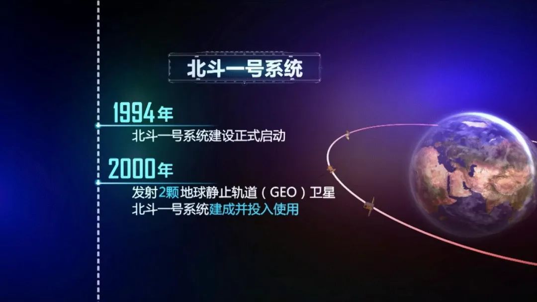
From 2000 to 2003, China completed the construction of the "Beidou Satellite Navigation Test System", and the Beidou Navigation Test System was in normal operation, becoming the third country with an independent satellite navigation system after the United States and Russia;
In 2004, Beidou-2 satellite navigation system started;
In 2006, China developed its own satellite navigation system, and the Beidou navigation plan was fully activated;
From 2007 to 2009, China launched three Beidou-2 satellites, which legally seized the dominant frequency;
In 2009, the construction of the Beidou-3 satellite navigation system was launched;
In 2012, China completed the second step of planning for navigation and positioning satellites, and built navigation and positioning in the Asia-Pacific region. Beidou-1 completed its mission and officially retired;
In 2015, two global system test satellites established the inter-satellite link for the first time, and conducted the inter-satellite link test between the middle orbit and the high orbit. This kind of test between the different orbit planes is the first time of the Beidou series;
In 2017, the Beidou-3 global networking double star was launched for the first time;
In 2018, the basic system of Beidou-3 was completed and covered the countries along the “Belt and Road”, and began to provide global services;
In 2019, the deployment of the core constellation of the Beidou-3 global system will be completed, and Beidou's global service capabilities will be fully realized;
In 2020, China will complete the constellation deployment of the Beidou global satellite navigation system and complete the construction to provide global positioning services;
In 2035, China will build a comprehensive positioning, navigation, and timing system (Positioning, Navigation, and Timing—PNT) with Beidou as the core
5. Four major functions and characteristics of Beidou satellite navigation system
(1) Four major functions of the Beidou navigation device:
Satellite communication short message function: send short messages to the command switchboard, another receiving device, or the ground information control center site through the "Beidou" satellite. The receiving device can communicate normally under any beam, and the specific beam can be specified by the user of the receiving device
Data interface control function: The "Beidou" satellite receiving device has a general standard data interface (RS232 serial port), which can transmit the signal received by the receiving device through the general interface.
Satellite positioning function: the receiving device can reliably and real-time output the current navigation geographic information such as latitude and longitude, altitude, speed, etc., and display it in a standard information way.
System time calibration function: the receiving device is equipped with a clock inside, which can be automatically checked with the received navigation information data packets.
(2) Seven major services of Beidou navigation device:
Positioning, navigation and timing service: Provide services to global users free of charge through 30 satellites. The global horizontal positioning accuracy is better than 9 meters, the vertical positioning accuracy is better than 10 meters, the speed measurement accuracy is better than 0.2 m/s, and the timing accuracy is better than 20 nanometers Second.
International Search and Rescue Service: Through 6 medium-circle earth orbit satellites, it aims to provide global users with distress alarm services that meet international standards. The return link is innovatively designed to provide distress search and rescue request confirmation services for rescuers.
Global short message communication service: Beidou system is the world's first satellite navigation system capable of global short message communication service. Through 14 medium-circle earth orbit satellites, it provides global random access services for specific users. The largest single The message length is 560 bits (40 Chinese characters).
Regional short message communication service: Beidou system is the first satellite navigation system in the world to provide regional short message communication service for authorized users. Through 3 geostationary orbit satellites, it provides data transmission services for users in China and surrounding areas. The largest unit The length of the sub-message is 14000 bits (1000 Chinese characters), and it has the ability to transmit text, pictures and voice.
Satellite-based augmentation service: Innovative integrated design satellite-based augmentation service, through 3 geostationary orbit satellites, aims to provide users in China and surrounding areas with Class I precision approach service in line with international standards, supporting single-frequency and dual-frequency multi-constellation two An enhanced service model that provides safety and security in the transportation sector.
Precise single-point positioning service: Innovative integrated design of precise single-point positioning service, through 3 geostationary orbit satellites, provides users in China and surrounding areas free of charge with positioning accuracy level better than 30 cm, elevation better than 60 cm, and convergence time better than 30 cm minutes of high-precision positioning enhancement services.
Ground-based augmentation service: A national network of ground stations has been built to provide real-time meter-level, decimeter-level, centimeter-level and post-event millimeter-level high-precision positioning enhancement services to industry and public users.
6. Advantages of Beidou satellites:
firstly, the integration of communication and guidance. The use of satellite positioning system for short message data transmission is the first of my country's Beidou satellite navigation system, which expands the application field of satellite positioning system. Therefore, the integration of communication and communication is a unique feature of Beidou navigation system.
Other satellite navigation systems can only passively locate, so users can only know "where I am", while Beidou users not only know "where I am", but can also tell others "where I am" and "what I am doing". For example, in the event of sudden earthquakes and distress at sea, when other communication methods fail, Beidou short message communication can become the last insurance for delivering distress information and saving lives. It has played an important role in disaster relief and reduction, field rescue, ocean fishery and other industries. Previously, this kind of application required professional equipment to achieve. At present, the short message chip can be integrated into the smartphone, which means that the short message communication function can be used only through the smartphone, so that users can pass through the Beidou in an emergency. Satellite signals transmit information and realize the satellite communication capability of smartphones.
Followed by the inter-satellite link. This is one of the highlights of the Beidou-3 global networking satellite, which greatly improves the ability of the satellite to operate independently. The satellites can communicate with each other through the on-board equipment, and share their positions with each other in real time. relative position. In this way, not only the coverage area is expanded, but also the efficiency is greatly improved. The independent network becomes the backup of the ground network. The biggest advantage of this technology is that it can realize all-weather and all-weather communication without relying on satellite ground stations. Without the support of this capability, it is necessary to go through the unified command of the ground station and issue instructions to individual satellites one by one. Therefore, it is necessary to build ground stations all over the world.
7. Beidou positioning application field
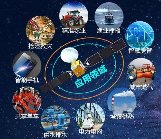
Precise Timing: Electricity, Communications, Finance, Base Stations, Transportation
Engineering construction: construction of roads, bridges and tunnels
Surveying and Mapping: Field Surveying and Urban Planning
Vehicle navigation: vehicle dispatching, monitoring system, vehicle anti-theft system
Ship navigation: ocean navigation, port/inland water diversion
Aircraft navigation: route navigation, approach and landing control
Personal Navigation: Personal Travel and Wilderness Adventures
Precision agriculture: agricultural machinery navigation, automatic driving, high-precision land leveling

The choice of GNSS positioning and navigation module can also be determined according to the type of satellite receiver : single GPS module, GPS+Beidou module, Beidou-3 positioning module, inertial navigation module, RTK module, etc. Beidou positioning module, Beidou G-Mouse is a series of high-quality GNSS product production testing software independently developed by Tiangong Measurement and Control for vehicle, industrial control and consumer applications, with rich experience in RF application design/EMC/ESD abnormal problem handling. Industrial-grade single-frequency/dual-frequency/multi-frequency multi-mode Beidou module, Beidou-3 positioning module and dual-frequency Beidou module (multi-mode), RTK Beidou module, Beidou timing module, Beidou inertial navigation module, antenna integrated Beidou module, Beidou G-Mouse. It supports joint positioning of multiple systems and independent positioning of a single system, and can realize functions such as real-time positioning, timing, and speed measurement of carriers, and can meet positioning and navigation applications in various industries.