When "Beidou" meets "Smart Water Conservancy", what kind of new ideas will be created ?
On June 7, the 2023 China Water Expo and the 18th China (International) Water Affairs Summit Forum were officially held. At the meeting, the concept of "Beidou space-time intelligence assisting water conservancy digital twins" and corresponding solutions proposed by Qianxun location attracted the attention of the participants, which also means that Beidou has received more and more attention in the field of smart water conservancy.
1. How to apply Beidou in the field of smart water conservancy?
As a satellite navigation system independently developed by my country, the Beidou system has been widely used in the fields of transportation, agriculture, forestry and fishery, hydrological monitoring, meteorological forecasting, communication systems, power dispatching, disaster relief and mitigation, and public safety since it provided services. economic and social benefits.
As an important pillar of social civilization and economic development, water conservancy has been highly valued by the country for its modernization. my country's "14th Five-Year Plan" clearly points out that the in-depth application of Beidou will be promoted in key areas such as water conservancy.

In December 2021, the first Beidou demonstration project of the Ministry of Water Resources, the Beidou Water Conservancy and Hydropower Comprehensive Application Demonstration Project, was approved and implemented. The Ministry of Water Resources seized the new opportunity of smart water conservancy construction and developed many new applications of the Beidou system in the water conservancy field:
1. "Millimeter-level" monitoring of reservoir dam deformation
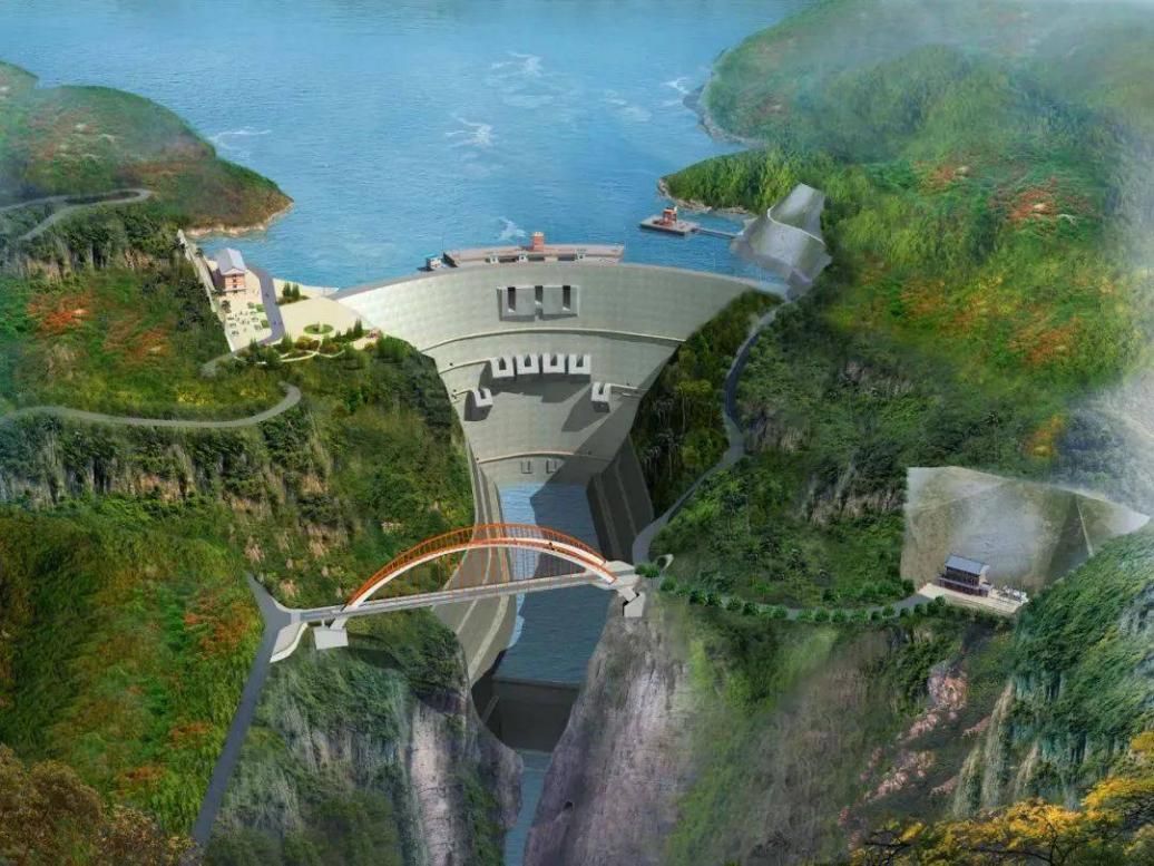
Reservoir dams, as important water conservancy hubs, exert huge engineering benefits and carry the arduous tasks of people's daily life and industrial and agricultural production. The dam will deform under loads such as its own weight, water pressure and temperature. When the deformation is too large, it may endanger the safety of operation. Therefore, the deformation monitoring of reservoir dam is a necessary means to grasp the operation status of the dam.

Traditional reservoir dam deformation monitoring uses manual timing and fixed-point measurement, which is time-consuming, laborious and inaccurate, and cannot meet the requirements of reservoir dam deformation safety monitoring under the new situation. Using the Beidou system to upgrade the dam monitoring work can realize continuous and precise monitoring of the dam deformation. Based on the Beidou high-precision positioning air-space-ground integrated safety monitoring system, the real-time observation accuracy is within ±3mm. Through technical research, a high-precision deformation monitoring device with a time-lapse observation accuracy of ±1 mm has been developed. The equipment can realize all-weather monitoring, and relevant staff can grasp the displacement trend of the dam in time.
2. Short message function to send "warning message"
As a space-based communication method, Beidou's short-message communication has all the advantages of satellite communication, such as all-weather, global wide coverage, and high reliability. It has fast response capability, short message communication delay is about 0.5s, point-to-point communication delay is 1~5s. The communication has strong anti-interference, and at the same time, it adopts S/L band satellite transmission, which can penetrate the stratosphere and troposphere, and can ensure communication under extreme weather conditions. The Beidou satellite RDSS short message service covers the whole country, which can realize the collection and return of rainwater regime information in uninhabited areas, weak signal, no public network and other areas, without the need to build communication base stations.
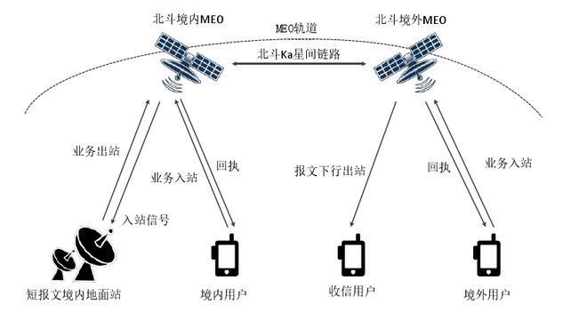
Schematic diagram of global short message communication
In severe weather conditions or special disaster environments, through the all-weather seamless automatic monitoring of Beidou satellites, real-time data collection ensures the timely transmission of rainwater regime information, which can solve the situation where manual monitoring cannot be carried out under special disaster weather conditions resulting in blind spots. It is suitable for mountain torrent monitoring and early warning, reservoir rainwater monitoring, river hydrological monitoring and other fields. It provides timely and accurate hydrological forecasting information for storm flood early warning and flood fighting and emergency rescue, and provides a solid guarantee for early warning work in critical flood control periods.
3. The details of water conservancy project construction can be seen at a glance
In the construction of extra-high dams and high slopes, the millimeter-level positioning of the Beidou system can be applied to automatic online high-precision monitoring of engineering surface deformation.
Based on the Beidou high-precision positioning technology, the location of rolling construction equipment can be obtained in real time, realizing comprehensive, three-dimensional, multi-level, and refined supervision of the construction process, reducing labor and material costs, and greatly improving construction efficiency and quality. Informatization of the whole process of engineering construction management.
4. Fill in the gaps in the basic data of special waters
There are many rivers in my country's special areas. These rivers are located in remote areas, have complex natural environments, lack of infrastructure such as intelligence and informatization, and it is difficult to obtain basic data such as hydrology.
The combination of Beidou navigation and positioning and satellite remote sensing technology can realize the basic data acquisition and information transmission of special waters.
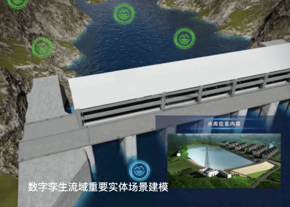
5. In-depth digital twin watershed construction
The digital twin watershed is the most distinctive feature and core and key of smart water conservancy construction, including the digital twin platform and information infrastructure. To realize the synchronization, interaction, simulation, and closed-loop of the physical watershed and the digital twin watershed, a strong space-time reference is needed as a support . Water flow, regulation and storage, and monitoring of the construction, management, and operation of water conservancy projects such as dams and dikes all have obvious temporal and spatial attributes. Therefore, as an important national space-time infrastructure, Beidou has broad and in-depth application prospects in the field of water conservancy, especially in the construction of digital twin basins.
2. The location of Qianxun makes Beidou and smart water conservancy ingeniously integrated?
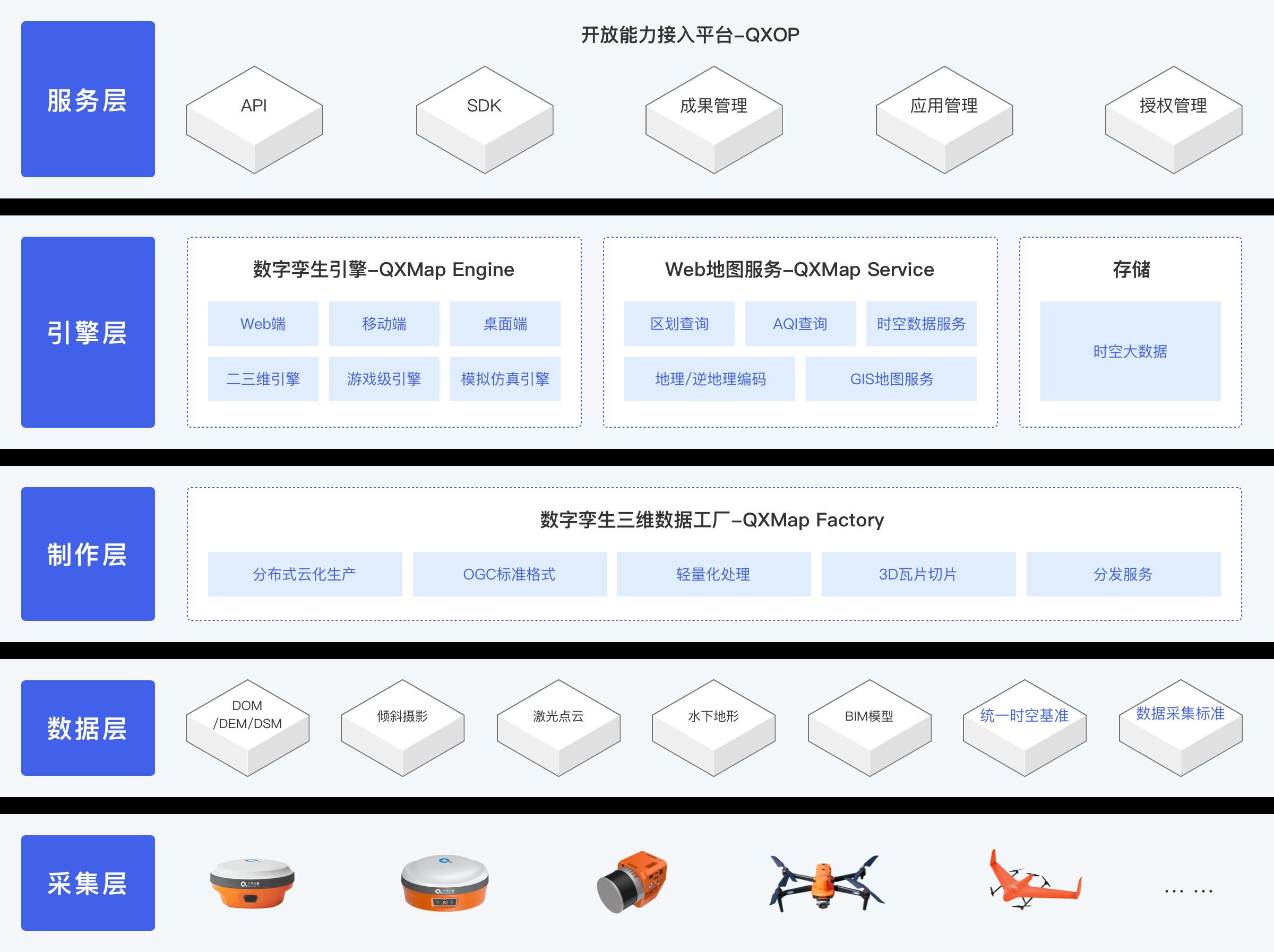
As a practitioner of the in-depth application of Beidou space-time intelligence in the water conservancy industry, Qianxun location makes full use of Beidou's high-precision positioning, unified space-time reference and short message communication capabilities, based on the digital twin core product independently developed and cloud map integration, and jointly A top partner in the industry, providing five innovative solutions for application scenarios such as water conservancy project safety monitoring, water environment management, river basin flood control, and urban waterlogging prevention: small and medium-sized reservoir rainwater forecasting and safety monitoring solutions, water conservancy and hydropower engineering Beidou/GNSS automation Deformation monitoring solutions, water environment intelligent management solutions, small and medium-sized watershed flood control, urban flood control and waterlogging comprehensive solutions, water conservancy digital twin geospatial data floor solutions.
Each solution has a complete architecture and provides full-process services including "water conservancy perception layer-communication transmission layer-platform support layer-business application layer-application scenarios":
Solutions for Rainwater Forecasting and Safety Monitoring of Small and Medium Reservoirs
Based on the underlying capabilities of the national Beidou ground-based augmentation system, combined with Beidou millimeter-level perception and short-message communication capabilities, it integrates a variety of monitoring sensors to provide intensive services under a unified time-space reference, and launched rainwater forecasting, dam safety monitoring, A small and medium-sized reservoir safety monitoring solution that integrates reservoir four-prediction, digital twin, engineering video surveillance, and safety monitoring platform.
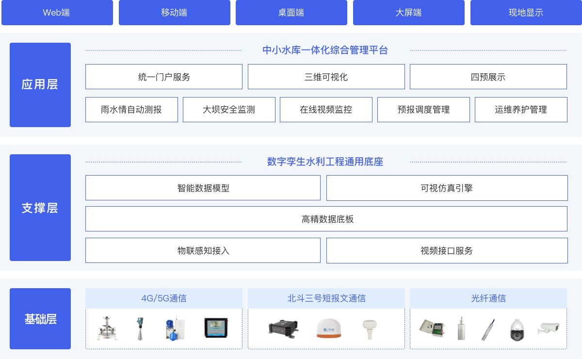
Solution Architecture for Rainwater Forecasting and Safety Monitoring of Small and Medium Reservoirs
Beidou/GNSS automatic deformation monitoring solution for water conservancy and hydropower projects
Taking the Beidou ground-based augmentation system as the unified space-time benchmark, we provide customers with Beidou/GNSS monitoring terminals and data calculation systems with patented technology, helping to realize high-precision and automatic appearance deformation monitoring of water conservancy and hydropower projects, reducing manpower investment and improving safety levels.
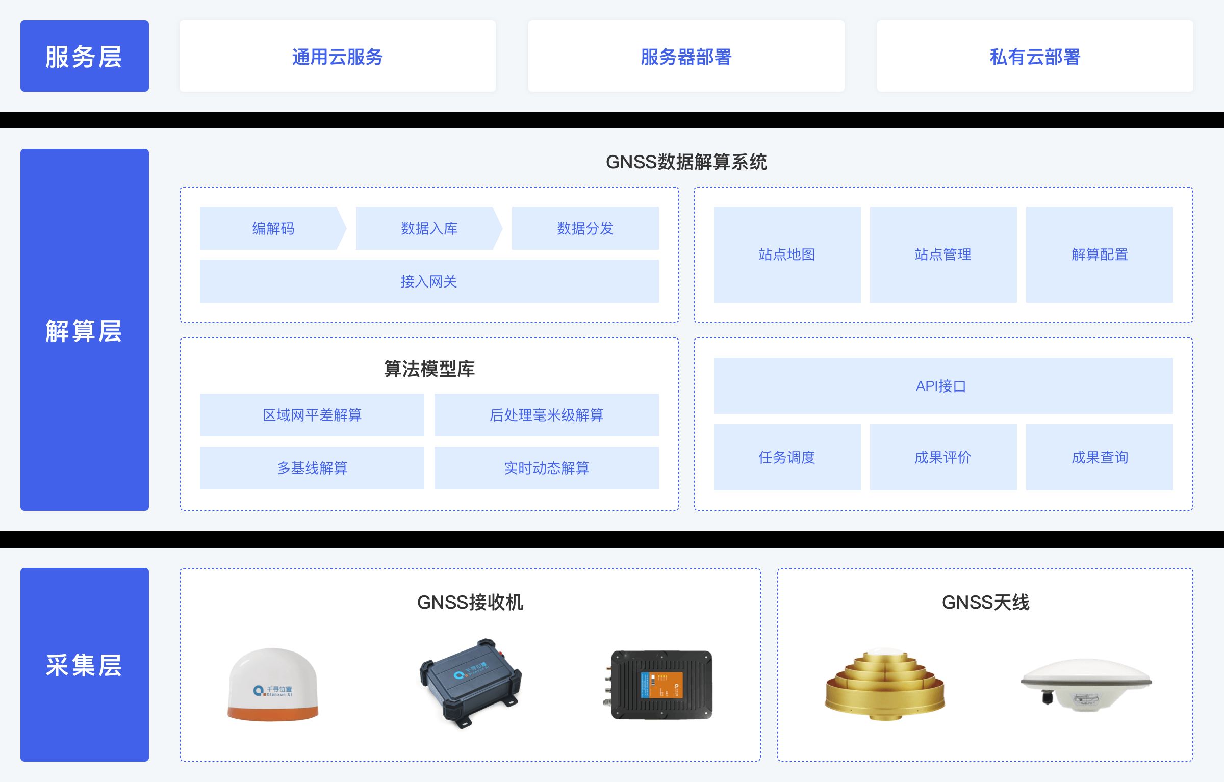
Solution Architecture of Beidou/GNSS Automatic Deformation Monitoring for Water Conservancy and Hydropower Projects
Water environment intelligent management solution
According to the core architecture of "one cabin (cockpit), two ends (governance end and server end), and N scenarios", build a water environment intelligent application, conduct three-dimensional, efficient, and intelligent inspections of the water environment, and form event discovery , Distribution, disposal to feedback of the whole process of online closed-loop processing, to achieve intelligent management of the water environment.
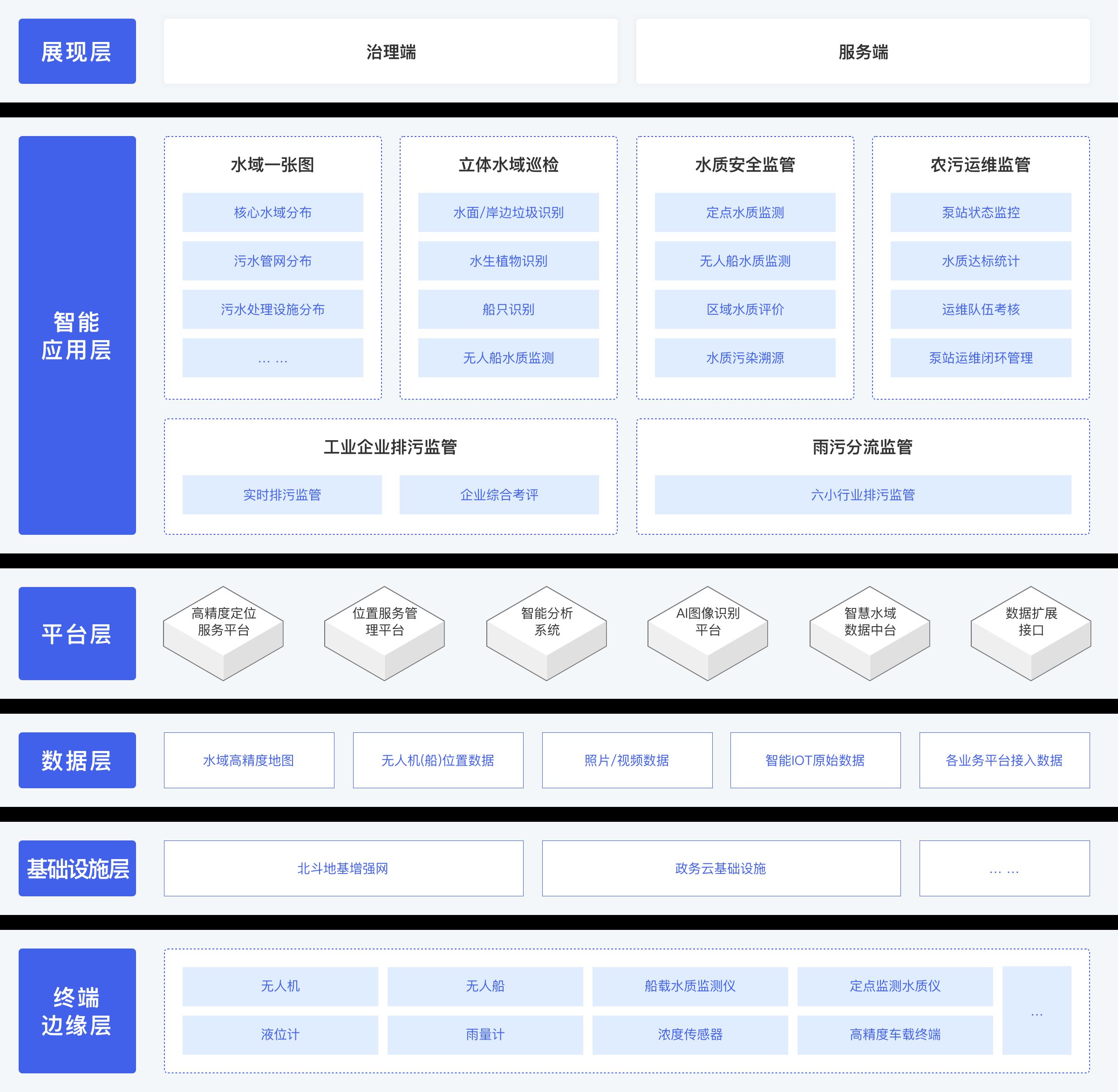
Solution architecture of water environment intelligent management
Comprehensive solutions for flood control in small and medium watersheds and urban flood control
Based on Beidou space-time intelligent technology, integrating Beidou high-precision positioning, unified space-time reference, and digital twin core products, more accurately establish a digital mapping of physical water conservancy and its affected areas, and the depth of the "four forecasts" of water conservancy business forecasting, early warning, rehearsal, and pre-plan Integrate to improve the digitalization, networking and intelligence level of flood control in small and medium watersheds and urban flood control.
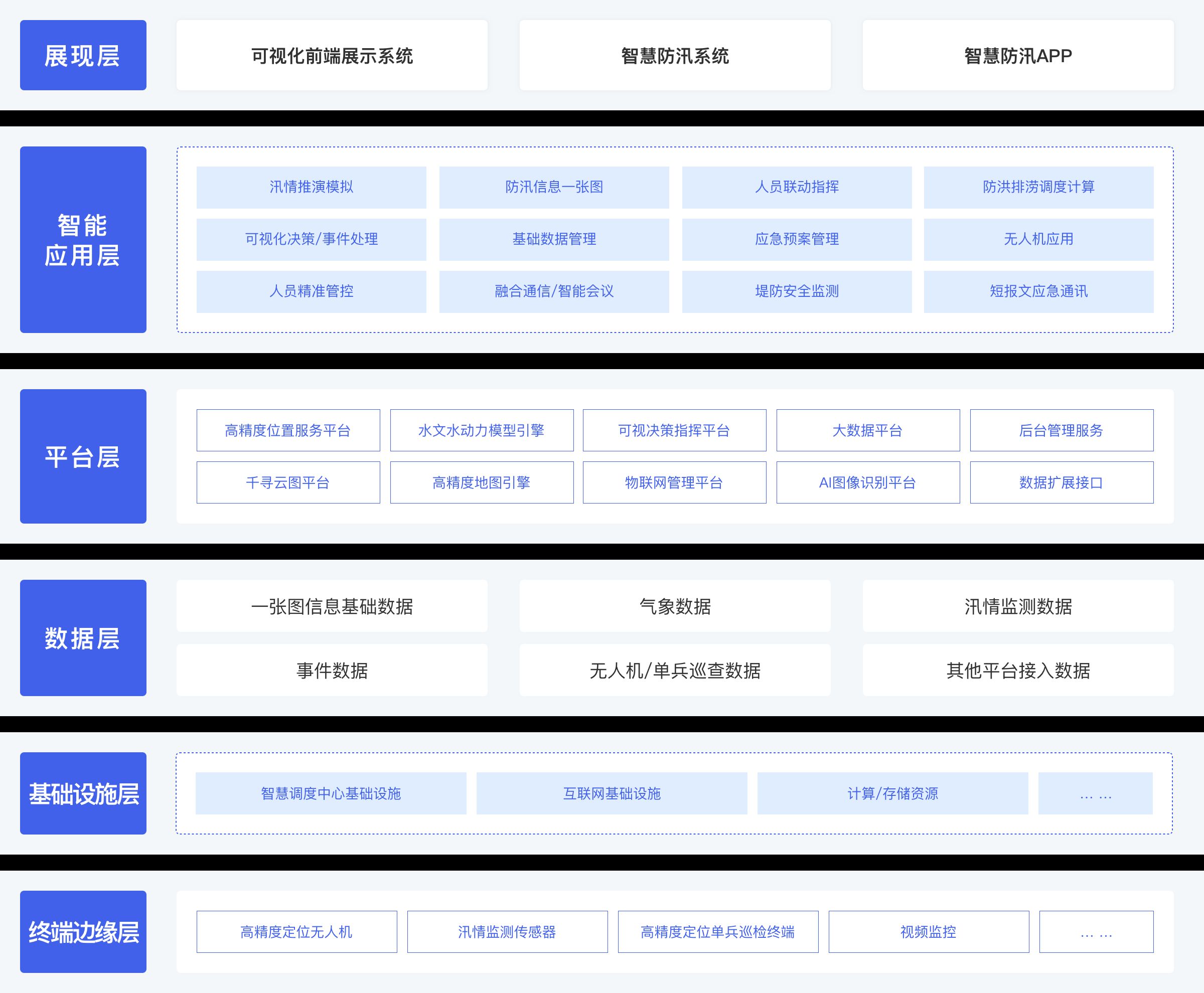
Integrated Solution Framework for Small and Medium Watershed Flood Control and Urban Flood Control and Waterlogging Control
Water Conservancy Digital Twin Geospatial Data Backplane Solution
With the goal of helping the construction of digital twin watersheds, relying on Beidou space-time intelligence technology, we will strive to create a geospatial data floor solution with unified global space-time reference, centimeter-level high precision, scene-based simulation, watershed-level 3D smooth loading, and ultra-realistic visualization.
Water Conservancy Digital Twin Geospatial Data Backplane Solution Architecture
Qianxun's water conservancy digital twin solution can fully release the application potential of the Beidou system in the water conservancy field. Since its launch, it has provided services for many water conservancy projects, achieving the effect of reducing costs, increasing efficiency, and improving intelligence. The following are four typical cases :
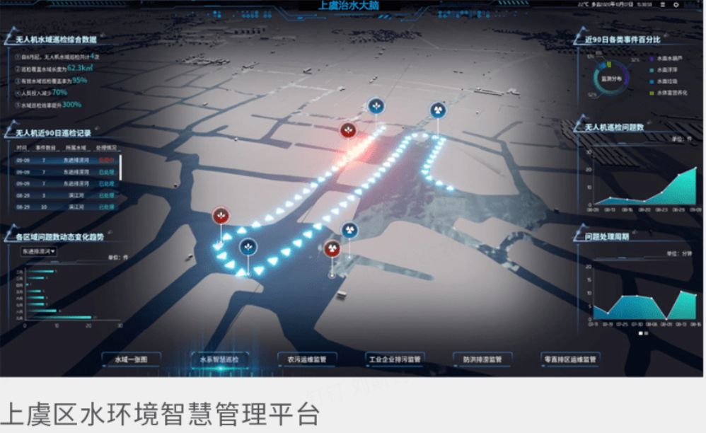
1. Shangyu, Zhejiang
From traditional manual boat inspections to automatic inspections by drones and unmanned ships, Qianxun has built a "water control brain" water environment intelligent management platform, which has increased inspection efficiency by 3-4 times.
2. Xianxia Lake in Suichang, Zhejiang
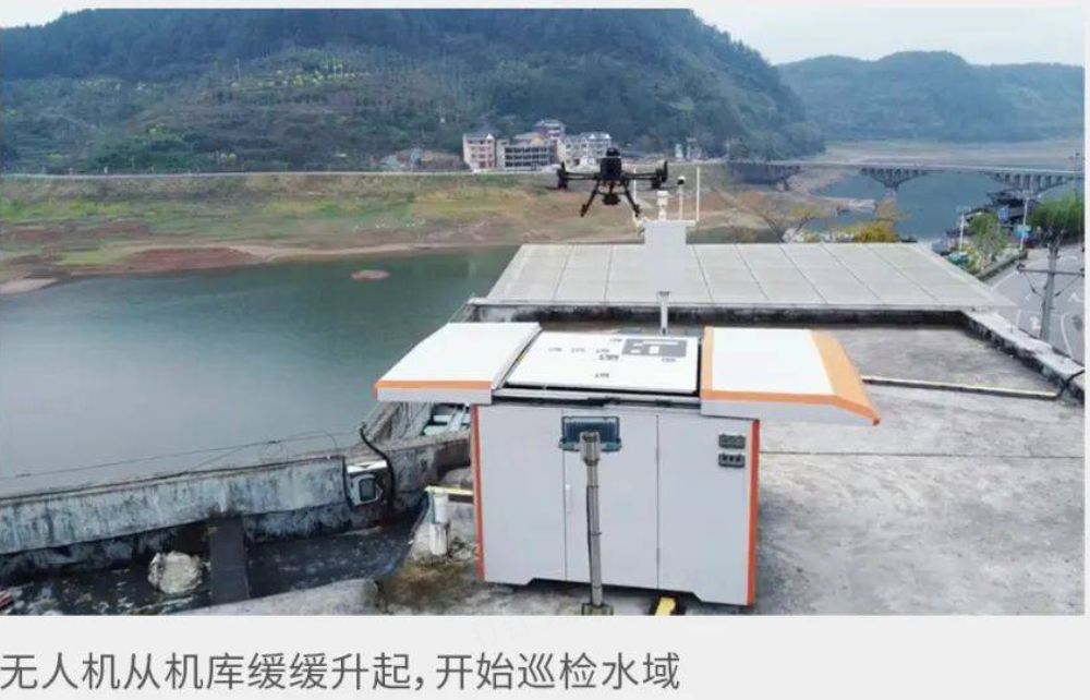
Xianxia Lake is an important drinking water source in Zhejiang. Qianxun Location integrates drones carrying high-precision services with Al image recognition, etc., improving the efficiency of water inspections by more than 400%, and reducing labor input costs by 80%.
3. Small reservoir in Ningming County, Chongzuo City
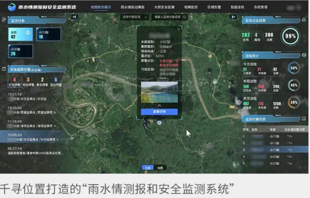
Qianxun has installed various monitoring and sensing equipment on dozens of small reservoirs in Chongzuo City, and automatically analyzes various data in the rainwater forecasting and safety monitoring system. Managers can know the rainwater situation without leaving home.
4. Guangxi Longtan Hydropower Station
Qianxun installed Beidou automatic monitoring equipment for the Longtan Hydropower Station. The staff can observe the vertical displacement changes of the dam slope of the Longtan Hydropower Station in real time through the computer, with an accuracy of millimeters.

Based on Beidou space-time intelligence technology, Qianxun location will continue to inject strong intelligent momentum into the development of my country's water conservancy industry and help the construction of water conservancy digital twins.