
Land use can be classified more efficiently as technology advances, especially in geographic information system (GIS) tools. The use of classifications to identify changes in vegetation cover, areas of illegal mining, and areas of vegetation suppression are just some of the many examples of land use classifications.
One of the difficulties with classification is determining the level of problem to be solved. What is the purpose of my classification? Does the classification need to have high accuracy to reduce the need to correct for human interaction? Is the purpose of classification just to identify changes over time? Will machine learning classification be used to ease the workload of the geographic team? Only free images can solve my problem?
Briefly describe the two types of learning used in this work, what is the difference betweenand deep learning ?
Machine learning is a form of machine learning, a subset of the field of artificial intelligence (AI), that enables systems to learn from human operators. This field of study uses data to train and find accurate results.
Deep learning or deep learning is already a subset of machine learning where models will learn from more complex neural networks. Algorithms are created just like machine learning, but with more complex layers and greater computing power.
A simpler way to understand this difference is that machine learning relies more on human intervention to learn, while deep learning does not rely on human intervention. According to Lex Fridman, deep learning is a "more scalable version of machine learning ".
The first approach is to use machine learning techniques for classification, where two types of methods such as unsupervised or supervised can be used and used in combination, known as hybrid classification.
Given the number of classes and the number of iterations, the algorithm is able to identify classes in an unsupervised way. This classification is often used by a grouping method called clustering.
Supervised methods require an operator that will create samples from an image and represent each class to be classified. For this work, I have chosen to use only supervised methods for machine learning.
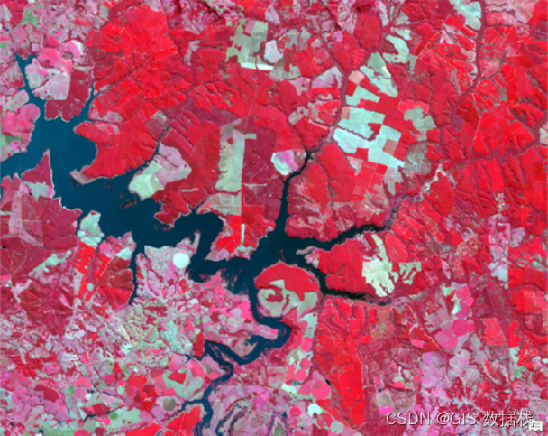
The first phase of this effort was to download Sentinel-2A images using the Earth Explorer platform . After downloading the image, I exported the 4 bands of interest to ArcGIS, the blue (B2), green (B3), red (B4) and infrared (B8) bands. Perform a false-color composite (8,4,3) between the bands and use a region of interest (ROI) to cut the composite.
Machine Learning Classification
The categories defined for the classification are: Water, Primary Forest, Bare Soil, Agriculture, Plantation, and Field, keeping in mind this work is just an example of application.
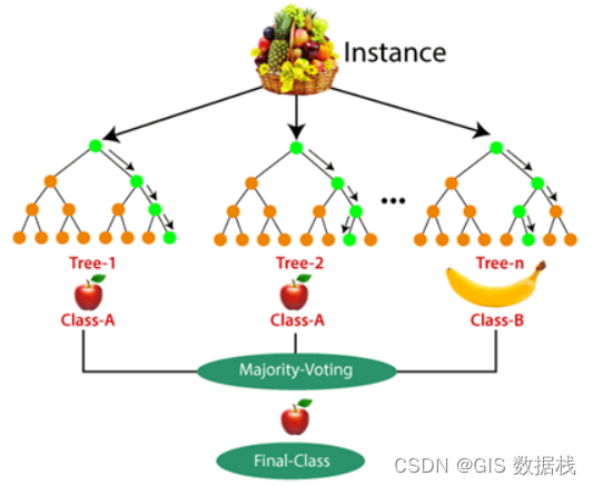
After defining the classes, I created samples in polygon format containing the images to be classified as a whole. I am using an object oriented approach with a random tree classifier, besides these there are other classifiers like: maximum likelihood, support vector machines, k-nearest neighbors.
A random tree classifier consists of decision trees run together, each tree decides a class, and the class with the most votes becomes the model prediction. Below is an example where the last class has the highest number of votes, in this case, in a fruit basket we have 2 apple trees and 1 banana tree, the last class will be defined as apples for display 2 /3 total votes.
For classification purposes, I have segmented composites, since it is a necessary step in the object-oriented approach. Segmentation groups pixels with similar characteristics and is an alternative to reducing scattered pixels in pixel-wise classification.
The tool used in this step is Image Classification Wizard , and the classification result is shown in the figure below. The image on the left represents RGB composition, and the image on the right represents classification.

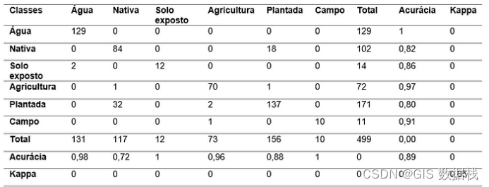
confusion matrix
After classification, I performed a confusion matrix with the inference samples. The main diagonal shows the number of samples assigned to each class in the "correct" way, the rows and columns show where the samples "wrong", using this data we can perform accuracy and Kappa index for our model. The confusion matrix shows 89 % accuracy and a kappa of 85% .
Deep Learning Ranking
In order to take advantage of the results of the last classification, I will convert the raster file to polygons and use it in the " Export training data for deep learning" tool, and then use some parameters as the basis for the model, and a rotation angle of 45°, This will help augment my images (samples). This step took approximately 2 hours and 51 minutes.
With the data exported, now comes the step of training the deep learning model. The next tool is the Train Deep Learning Model , I use 10 epochs, which is the number of times the model goes through the entire layer, and the Resnet34 architecture, a neural network for more complex training, after which I use 10% of these data for the model verify.
After 1 hour and 40 minutes, the model was trained with an accuracy of about 79% . Now comes the most awaited step, we are going to test our model, I will use the same combination but train it in a different place. The tool used in this step is Classify Pixels Using Deep Learning , the result is shown in the figure below, I compared the true color image with the classification result.

In both classifications, there are issues between native vegetation and plantations, and between fields and agriculture, but the main purpose of this work is to come up with both forms of classification based on machine learning.
The machine learning classification was 89 percent accurate, while the deep learning classification was 79 percent. This does not mean that one classification is better than the other, but that more testing is required in both learnings.
In some cases, using machine learning to classify land use is already a solution, but in more complex cases, it is necessary to use deep learning .