本文为法国巴黎东方大学(作者:Karim Hammoudi)的博士论文,共234页。
本文旨在开展三维建筑建模的研究。特别是90年代以来,基于空中的三维建筑物重建研究是一个非常发达的课题。然而,由于实际的大规模建筑三维重建方法(虽然效率高)在通用性、一致性、准确性等方面仍然存在问题,因此有必要进行深入的研究。另外,街道采集系统(如移动地图系统)的最新发展为建筑物建模的改进开辟了新的前景,因为地面数据(非常密集和准确)可以利用更高的性能(与空中调查相比)来丰富建筑物立面层的模型(例如几何、纹理)。因此,分别提出了基于空中和地面的建筑物建模方法。在空中,我们描述了一种直接和无特征的方法,从一组校准的空中图像重建简单的多面体建筑物。在地面上,提出了几种基本描述三维城市立面造型管道的方法,即街道点云分割与分类、城市立面几何造型和无遮挡立面纹理。
The aim of this work is to develop research on 3D building modeling. Inparticular, the research in aerial-based 3D building reconstruction is a topic verydeveloped since 1990. However, it is necessary to pursue the research since theactual approaches for 3D massive building reconstruction (although efficient)still encounter problems in generalization, coherency, accuracy. Besides, therecent developments of street acquisition systems such as Mobile MappingSystems open new perspectives for improvements in building modeling in thesense that the terrestrial data (very dense and accurate) can be exploited withmore performance (in comparison to the aerial investigation) to enrich thebuilding models at facade level (e.g., geometry, texturing). Hence, aerial andterrestrial based building modeling approaches are individually proposed. Ataerial level, we describe a direct and featureless approach for simplepolyhedral building reconstruction from a set of calibrated aerial images. Atterrestrial level, several approaches that essentially describe a 3D urbanfacade modeling pipeline are proposed, namely, the street point cloudsegmentation and classification, the geometric modeling of urban façade and theocclusion-free facade texturing.
1 引言
2 从航空影像中提取三维多面体建筑模型
3 地面城市激光数据的性质
4 地面城市街道点云的分割与分类
5 从图像和激光数据进行正面建模和无遮挡纹理处理
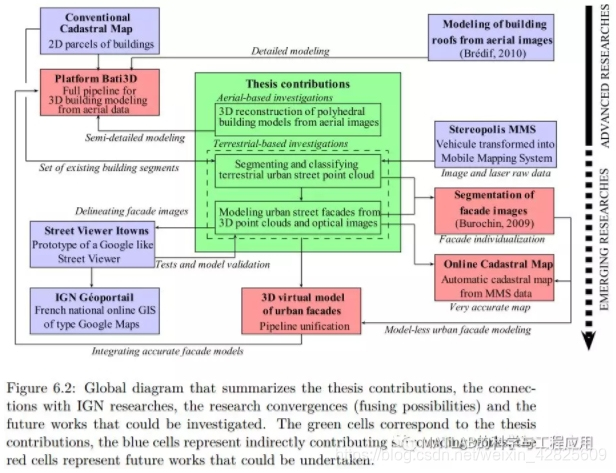
6 结论与未来工作展望
更多精彩文章请关注公众号: