A/D analogue-to-digital 模拟信号到数字信号
AFOV angular field of view 角度视场角
AGL average ground level 平均底面高度
AIC aerial industrial camera 航空工业相机
ALPS airborne laser polarzation sensor 机载激光极化传感器
ALPS airborne laser profiling system 机载激光扫描系统
ALS airborne laser scanning 机载激光扫描
ALTMS airborne LiDAR terrain mapping system 机载激光雷达地形测绘系统
AM amplitude modulation 波幅调制
AOL airborne oceanographic LiDAR 机载海洋激光雷达
APD avalanche photodiode detectors 雪崩二极管探测器
ASCII American Standard Code for Information Exchange ASCII码
ATLAS airborne topographic lasar altimeter system 记载制图激光测高系统
BSP-Tree binary space partition tree 二叉树
CATS coastal area tactical-mapping system 海岸线制图系统
CCD charged-coupled device CCD
CCNS computer-controlled navigation system 计算机控制的导航系统
CFRP carbon fiber reinforced plastic 碳纤加强塑料
CHM canopy height model 冠层高度模型
CLF compass line filter 指南针过滤器
CMOS complementary metal-oxide semiconductor CMOS
CORS continuously operating reference stations 连续运行参考站 cors站
COTS commercial -off-the-shelf 商业成品组件
CSG constructive solid geometry 构造实体几何 体素构造表示
CT contour tree 等高线树(等高线树是描述等高线空间拓扑关系的一种数据存储结构,主要包括父子的隶属层次关系或包含关系以及邻接或者兄弟并列关系。)
CW continuous waveform 连续波
DCM digital canopy model 数字冠层模型
DCM direction consine matrix 方向余弦矩阵(参考详解:
https://mp.weixin.qq.com/s?__biz=MjM5MDk4MDQ2MA%3D%3D&idx=2&mid=2651290236&sn=cc0f12df0a2d9b292b446f85060613a0
)
DEM digital elevation model 数字高程模型
DGPS differential global positioning system 差分全球定位系统
DSM digital surface model 数字表面模型
DSS digital sensor system 数字传感器系统
DTM digital terrain model 数字地形模型
EAARL experimental advanced airborne research LiDAR 实验性先进机载研究lidar
EDM electronic distance measuring 电子测距
EKF extended kalman filter 扩展卡尔曼滤波
EOP exterior orientation parameters 外方位元素
EPFL federal institute of technology of lausanne
瑞士联邦理工学院-洛桑
ESSP earth system science pathfinder 地球系统科学探路者项目
FLI-MAP fast laser imaging mobile airborne platform 快速激光制图移动机载平台
FM frequency modulation 调频
FOG fiber-optic gyros 光纤陀螺
FOV field-of-view 视场角
FWHM full-width at half the maximum 半波宽度
GCP ground control point 地面控制点
GIS geographic information system 地理信息系统
GLAS geoscience laser altimeter system 地理科学激光测高系统
GML geography mark-up language 地理标记语言
GNSS global navigation satellites system 全球定位卫星系统
GPS global positioning system 全球定位系统
GSD ground sample distance 地面采样距离
GSD ground spacing distance 地面空间距离
HDTV high definition television 高分辨率电视
ICESat ice,cloud and land elevation satellite 雪、云及地面高程卫星
ICP iterative closest point 迭代最近点
IDW inverse distance weighted 反距离加权
IFOV instantaneous field of view 瞬时视场角
IPP instrument incubator program 仪器孵化器项目(nasa的一个科研项目)
IOP interior orientation parameters 内方位元素
IPAS inertial position and attitude system 惯性位置及高度系统
IQR interquartile range 四分间距 四分位差
ISODATA iterative self-organizing data analysis technique 迭代自组织数据分析技术(非监督分类方法的一种)
ITC individual tree crown 独立树冠
KF kalman filter 卡尔曼滤波
LADS laser airborne depth sounder 机载激光测深仪
LCD liquid crystal display 液晶显示
LiDAR light detection and ranging 激光雷达
LITE LiDAR in-space technology experiment 激光雷达空间实验
LKF linearized kalman filter 线性卡尔曼滤波
LoD levels of detail 详尽程度
LOLA lunar orbiter laser altimeter
月球轨道飞行器激光测高仪
LRU laser ranging unit 激光测距组件
LSA least squares adjustment 最小二乘平差
LSM least squares matching 最小二乘匹配
L
VIS laser vegetation imaging sensor 激光植被成像传感器
MAPL multiwavelength airborne polarimetric LiDAR 多波段机载激光雷达
MBLA multibeam laser altimeter 多光束激光测高
MBR minimum bounding rectangle 最小外包多边形
MCP microchannel plate 微通道板
MDL minimum description length 最小探测距离
MLA MESSENGER laser altimeter 信使激光测高仪(参考文献:
MESSENGER laser altimeter
)
MMLA multi-kilohertz micro-laser altimeter 高频率微型激光测距仪
MOLA mars orbiter laser altimeter 火星轨道激光测距仪
MPP multipurpose platform 多任务平台
NDVI normalized difference vegetation index 归一化植被指数
OEM original equipment manufacturer 原厂商
OMSD opto-mechanical scanning device 光机扫描设备
PALS portable airborne laser system 便携式机载激光系统
PCA principal component analysis 主成分分析
PCD phase coded disk 相位编码盘
PDA personal digital assistant 掌上电脑(个人数字化助理)
PMT photomultiplier tube 光电倍增管
POS position and orientation system 位置与方向系统
PPP precise point positioning 精确点位
PPS pulse per second 每秒脉冲数
PRF pulse repetition frequency 脉冲重复率(解释参考:
http://blog.163.com/wangqing_rs/blog/static/164515191201132052956665/
Pulse Repetition Frequency (PRF)
The frequency of pulse transmission affects the maximum range that can be
displayed. Recall that the synchronizer resets the timing clock as each new pulse
is transmitted. Returns from distant targets that do no reach the receiver until
after the next pulse has been sent will not be displayed correctly. Since the timing
clock has been reset, they will be displayed as if the range where less than actual.
If this were possible, then the range information would be considered ambiguous.
An operator would not know whether the range were the actual range or some greater
value.
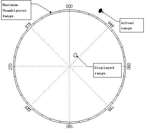
Figure 8
The maximum actual range that can be detected and displayed without ambiguity, or the maximum unambiguous range, is just the range corresponding to a time interval equal to the pulse repetition time, PRT. Therefore, the maximum unambiguous range,
When a radar is scanning, it is necessary to control the scan rate so that a
sufficient number of pulses will be transmitted in any particular direction in order
to guarantee reliable detection. If too few pulses are used, then it will more
difficult to distinguish false targets from actual ones. False targets may be present
in one or two pulses but certainly not in ten or twenty in a row. Therefore to
maintain a low false detection rate, the number of pulses transmitted in each
direction should be kept high, usually above ten.
)
QA quality assurance 质量保障
QC quality control 质量控制
RAG region adjacency graph 区域邻接图(
解释参考:
区
域邻接图
区
域邻接图
(region adjacency graphs, RAG)表示图像中区域与区域之间的关系,它主 要强调由区域构成的图像的划分和每一个划分的特性
)
RANSAC random sample consensus 随意采样一致性算法
RASCAL raster scanning airborne lidar 栅格扫描机载lidar
RMS root mean square 均方根
RMSE root mean square error 均方根差
RTF recursive terrian fragmentation 迭代地形碎片(解释参考:
碎片
的
迭代
次数,值越小,
地形
越平缓
)
SHOALS scanning hydrographic operational airborne LiDAR survey 水文机载激光雷达测绘(参考解释:
http://ieeexplore.ieee.org/document/688965/?reload=true
)
SIMP Swath mapping multi-polarization photon-counting
SLA shuttle laser altimeter
SLICER scanning LiDAR imager of canopies by echo recovery (解释参考:
Lefsky, M.A., W.B. Cohen, S.A. Acker, G.G. Parker, T.A. Spies, and D. Harding (1999). Lidar Remote Sensing of the Canopy Structure and Biophysical Properties of Douglis-Fir Western Hemlock Forests.
Remote Sensing of Environment
, Vol. 70, pp. 339-361.
)
SNR signal-to-noise ratio 信噪比
SPAD single photon avalanche diode 单光子雪崩二极管
SPCM single photon counting modules 单光子计数模块
SRS stellar reference system 恒星参考系
TIN triangulated irregular network不规则三角网
TOF time-of-f ight tof测量方式
UKF unscented Kalman filter 无迹卡尔曼滤波算法
UTM universal transverse mercator 通用横轴墨卡托投影
VCL vegetation canopy LiDAR 植被冠层激光雷达
VGA variable gain-state amplifier 可变增益状态放大器
VRML virtual reality modeling language 虚拟现实模型预演
XML extensible markup language 可拓展性标记语言