foreword
The coordinate system conversion process is as follows: Therefore, we must first understand the conceptual differences between different coordinate systems.

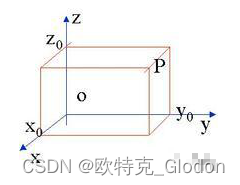
(1) Space rectangular coordinate system
The coordinate origin of the space Cartesian coordinate system is located at the center of the reference ellipsoid, the Z-axis points to the north pole of the reference ellipsoid, the X-axis points to the intersection point of the initial meridian plane and the equator, and the Y-axis is located on the equator plane. The coordinates of a point can be expressed by the projection of the point on each coordinate axis of this coordinate system. The space Cartesian coordinate system can be used as shown in the following figure:
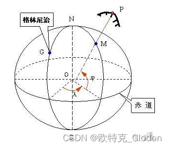
(2) Geodetic coordinate system
The geodetic coordinate system uses geodetic latitude, longitude and geodetic elevation to describe the spatial position. Latitude is the angle between the point in space and the normal of the reference ellipsoid and the equatorial plane; longitude is the angle between the point in space and the plane where the rotation axis of the reference ellipsoid is located and the starting meridian of the reference ellipsoid; the geodetic elevation is The distance between a point in space and the reference ellipsoid along the normal direction of the reference ellipsoid.
Elevations of ground points and national elevation datums
(1) Absolute elevation. The distance from the ground point to the geoid along the vertical line is called the absolute height or altitude. In the past, my country used the mean sea level of the Yellow Sea obtained from the observation results of the tide gauge station in Qingdao from 1950 to 1956 as the zero point of the elevation, which was called the "Yellow Sea elevation system in 1956" (Huanghai height system 1956 level origin elevation is 72.289m ). After re-examination, it was found that the tide gauge data of this elevation system was too short and the accuracy was poor, so the observation data of Qingdao tide gauge station from 1950 to 1979 were used to recalculate, and it was named "1985 National Elevation Datum" (Chinese height datum 1985). The national leveling origin (leveling origin elevation is 72.260m) is set near Guanxiang Mountain in Qingdao City, which serves as the basis for elevation measurement in my country. Its elevation value is calculated based on the zero point of the mean sea level determined by the "National Elevation Datum in 1985". When using the elevation results of the original "Yellow Sea Elevation System in 1956", attention should be paid to converting it into the new elevation datum system.
(2) Relative elevation. The distance from a ground point to any assumed level along the plumb line is called the relative elevation of the point, also known as the assumed elevation. In Figure 1-5, the relative elevations of ground points A and B are H'A and H'B, respectively.
(3) Height difference. The difference between the elevation (absolute elevation or relative elevation) of any two points on the ground is called height difference.
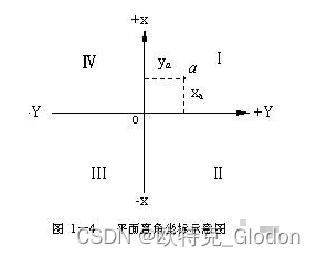
(3) Plane rectangular coordinates
Plane Cartesian coordinates: If the coordinate origin o is assumed arbitrarily, it is an independent planar Cartesian coordinate system.
Since the direction used in the measurement is measured in degrees clockwise from the north direction (vertical axis direction) (the quadrants are also numbered clockwise). Therefore, after exchanging the x and y axes of the plane Cartesian coordinate system (the angle value is counted counterclockwise from the positive direction of the horizontal axis) in mathematics, the calculation formula of trigonometric functions in mathematics can be directly used for measuring data without change calculate.
(4) Gauss-Kruger plane Cartesian coordinate system (projected coordinate system)
(Here, the Gauss-Kruger plane Cartesian coordinate system in gis is mainly used, not the plane coordinate system in mathematics)
The plane coordinate system established according to the Gauss-Kruger projection, or the Gauss plane coordinate system for short. It is a plane coordinate system widely used in geodetic surveying, urban surveying, general surveying, various engineering surveying and map drawing. The Gauss-Krüger projection was proposed by CF Gauss of Germany in 1822, and then expanded and perfected by JHL Krüger of Germany in 1912. Geodetic coordinates represented by geodetic longitude and latitude are coordinates on an ellipsoidal surface and cannot be directly applied to mapping. Therefore, they need to be transformed into plane Cartesian coordinates according to certain mathematical laws. The general mathematical notation for transforming geodetic coordinates (B, L) into plane Cartesian coordinates (X, Y) is: X=F1(B,L), Y=F2(B,L), where F1 and F2 are projection functions .
The projection function of the Gauss-Kruger projection is determined according to the following two conditions: First, the projection is regular, that is, the infinitesimal figure on the ellipsoid is similar to its appearance on the plane, so it is also called conformal projection or Conformal projection; the length ratio of any point on the projection surface (the ratio of the differential distance of the point on the ellipsoid to its corresponding differential distance on the plane) is independent of the orientation. Second, the appearance of a certain meridian on the ellipsoid surface on the projection plane is a straight line, and the length remains unchanged, that is, the length ratio is equal to 1. This meridian is called the central meridian, or the axial meridian. These two conditions embody the characteristics of the Gauss-Krüger projection.
The geodetic coordinate system is the basic coordinate system of geodetic surveying. It is often used for detailed calculation of earth problems, research on the shape and size of the earth, compilation of maps, rocket and satellite launches, and military positioning and calculation. It is inconvenient to use it directly for engineering construction planning, design, and construction. Therefore, the geodetic coordinates on the spherical surface must be reduced to the plane according to certain mathematical rules, that is, the topographic map can be drawn using the theory of map projection before it can be used for planning and construction. The surface of the ellipsoid is a curved surface that cannot be directly expanded, so projecting the elements on the surface of the ellipsoid onto the plane according to certain conditions will always cause deformation. In measurement, the projection method is often selected on the condition that the projection deformation does not affect the engineering requirements. There are three kinds of map projections: conformal projection, equal area projection and arbitrary projection. Among them, the conformal projection is also called the conformal projection, which ensures that the differential graphics on the ellipsoid surface will remain similar after being projected onto the plane. This is the basic requirement of topographic maps.