The GIS Map Server control adds dynamic map functionality to the GLG toolkit and can be used with the toolkit or independently. When used with the toolkit, an integrated GIS object will be responsible for zooming, panning, co-transformation and map transformation, as well as integrating the map server into the GLG drawing functionality. They can also be updated in real-time as the toolkit handles the transition of the dynamic icons at the top of the map.
The latest release has the following updates:
- GLG Map Server newly supports PNG format. PNG images can be used as input images and tiles for image layers, as well as icons for vector layers.
- GLG Map Server also supports PNG images with alpha channel. Alpha-channel allows defining transparency on a per-pixel basis, which can be used to display weather and clouds overlaid on maps. PNG images with an alpha channel can also be used as icons, with a transparent background, without the need to define a transparent color in the layer's LIF file.
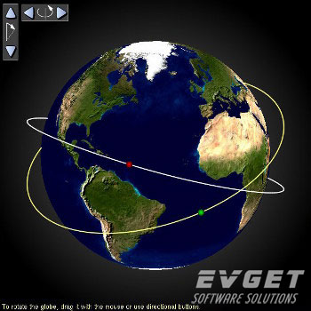
- Changed the handling of Z coordinates for objects located in GIS Objects. Previously, the X and Y coordinates of an object in a GIS Object were treated as longitude and latitude to allow positioning the object in GIS coordinates, while the Z coordinate was ignored. In the new version, the Z coordinate is interpreted as the distance above the earth's surface in meters, which makes it possible to display the orthographic projection of the satellite's orbit on the earth, as shown in the image below:
- Modified the logic of clipping orthographic projection. When the GIS Object clips parts, the application only displays the part of the earth, which makes it possible to create an orthographic zoomed-in area picture on the horizon, such as the trajectory of a rocket on the map. As shown below:
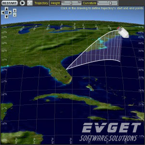
- A new BACKGROUND layer type has been added to Map Server to define gradients outside the orthographic globe. In the image above, the BACKGROUND layer is used to render the sky above the horizon.
Click to download >> GIS Map Server latest version