Oblique photography technology is a high-tech developed in recent years. It acquires rich high-resolution textures of the top and side views of buildings by simultaneously capturing images from five different viewing angles. In recent years, many domestic enterprises have also begun to widely learn and apply oblique photography technology, and optimize work methods and improve work efficiency through real-life 3D models.
Wish3D has always shared with you a lot of tutorials and application cases of real-world 3D models, but they are relatively fragmented. In this " real 3D series ", we will systematically introduce the emergence, development and application of real 3D models, and you are welcome to pay attention.
Live 3D Series 1 | Oblique Photography Development History Catalog
-
How did drones go to the consumer level?
-
How did oblique photography technology develop?
-
What are the oblique photography modeling software and application software?
- How did drones go to the consumer level?
Unmanned Aerial Vehicle (UAV), referred to as "UAV", is an unmanned aerial vehicle controlled by electronic equipment. Compared with manned aircraft, UAV has the characteristics of small size, convenience and flexibility, and low cost. UAVs first appeared in the military field as "target drones"; with the maturity of technology and the reduction of production costs, they gradually entered the civilian field.
According to the application field, UAVs can be divided into military UAVs and civilian UAVs, and civilian UAVs can be divided into professional UAVs and consumer UAVs. Professional-grade UAVs are mainly used in professional fields such as meteorological remote sensing, communication relay, agriculture, forestry and environmental monitoring; while consumer-grade UAVs are mainly used for mass consumption, such as life photography, navigation, entertainment, etc.
The history of drones can be traced back to 1914, however, the first drone in the true sense should be the Queen Bee drone developed in the UK in the 1930s.

1935: DH.82B Queen Bee drone
Since the 21st century, countries have continued to increase investment in military UAVs, and have also adopted various means to promote the development of UAVs into the civilian field. NASA established a UAV Application Center in 2002 dedicated to civilian research on UAVs. In China, on August 3, 1958, Northwestern Polytechnical University developed China's first unmanned aerial vehicle system, which was successfully tested at Xi'an Yaocun Airport, creating a precedent for my country's unmanned aerial vehicle industry. However, as of 2006, my country's UAV industry is still mainly military, and the development of civilian UAVs is very slow and can almost be ignored.
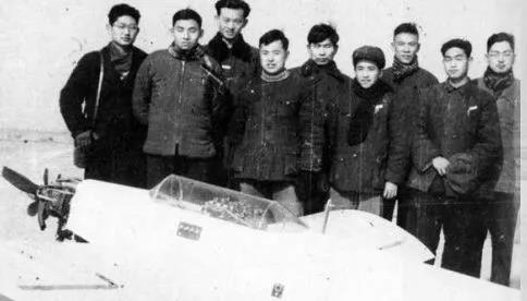
In 1958, Northwestern Polytechnical University developed China's first unmanned aerial vehicle system
In 2006, Wang Tao founded DJI Technology Co., Ltd. in Shenzhen to focus on consumer drones. Since then, companies such as Zero Intelligent Control, Jifei Technology, and Yihang Technology have been established one after another, and the Chinese civil drone market has begun to develop rapidly. After 2013, the Chinese drone market has become increasingly popular, and large enterprises have adopted various methods to get involved in the civilian drone industry. The popularity of consumer drones has greatly promoted the development and application of oblique photography technology.
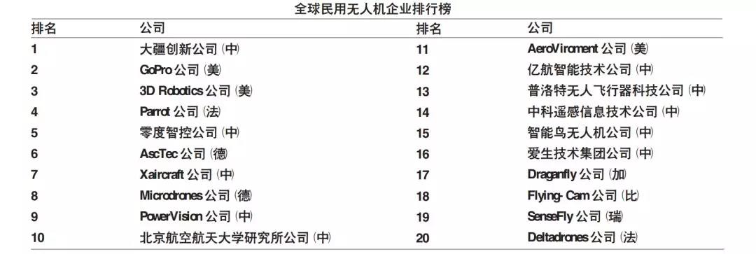
In 2015, Internet Weekly focused on the scale and development history of enterprises.
Test, ranking the world's civilian drone companies
- How did oblique photography technology develop?
The earliest aerial photography in history: the famous French photographer Nadal was the first person in the history of human aerial photography. After numerous failures, in December 1858, he used an old-fashioned wet version camera on a hot air balloon for 20 years. Minutes from painting to shooting to rinsing in the darkroom of the gondola. This great initiative turned human imagination into reality and shared God's perspective with human beings. Of course, aerial photography also became a new type of reconnaissance method in World War I.

French photographer Nadal
It is not difficult to find that those early aerial photography platforms chose to use hot air balloons, and aerial photography became the main stage of modern drones after World War II.
The oblique photogrammetry technology originally originated abroad. Earlier, the automatic modeling technology acquired by Apple Inc. of the United States attracted widespread attention at home and abroad. Later, the oblique aerial camera and the corresponding automatic modeling software were successively launched.
国内只是在近几年才兴起 。2010年初,天下图公 司从美国引进了Pictometry倾斜摄影测量系统,这 一事件标志着我国倾斜摄影测量技术的研究拉开了序幕。同年10月,刘先林院士团队率先研发成功了第一款国产倾斜相机SWDC-5并通过与东方道迩公司的合作,成功实施了长春市倾斜摄影工程项目 。2014年6月,为了使全国用户能够更好的享用倾斜摄影技术服务,多家优秀企事业单位联合成立了全国倾斜摄影技术联盟 。
- 倾斜摄影建模软件、应用软件都有哪些?
全自动化的生产方式大大减少了建模的成本, 模型的生产效率大幅提高,大量的自动化模型涌现出来。国外自动化建模软件包括法国Air Bus公司的Street Factory,俄罗斯Agisoft公司的PhotoScan,瑞士Pix4D公司Pix4D mapper,以及Bentley公司的Context Capture等 。
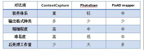
建模软件在国内比较有代表性的是Context Capture、街景工厂、Photoscan、Pix4D及 Skyline的Phomesh。
Context Capture是Bentley公司收购法国Acute3D 软件技术后推出的首款实景三维建模软件,该软件在Smart3D Capure软件的基础上进行升级 ,采用世界上最先进的数字图像处理技术和计算机视觉图形算法,通过简单的连续影像即可生成 层次细节丰富的3D模型 。只要输入照片的分辨率和精度足够,生成的三维模型是可以实现无限精细的细节。Context Capture软件支持现有的各种倾斜航摄仪系统,同时能输出点云及各种通用兼容格式的模型成果,可方便地在三维地理信息平台中加载,有利于对模型的编辑分析 。
针对倾斜模型数据量大无法加载、地物无法单体化等问题,国内很多公司也开始自主研发实景三维模型应用软件。超图公司于2014年下半年推出了SuperMap GIS7C 软件, 在实景三维模型上进行数据挖掘扩展了其应用,取得了不错的效果 。
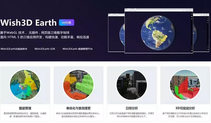
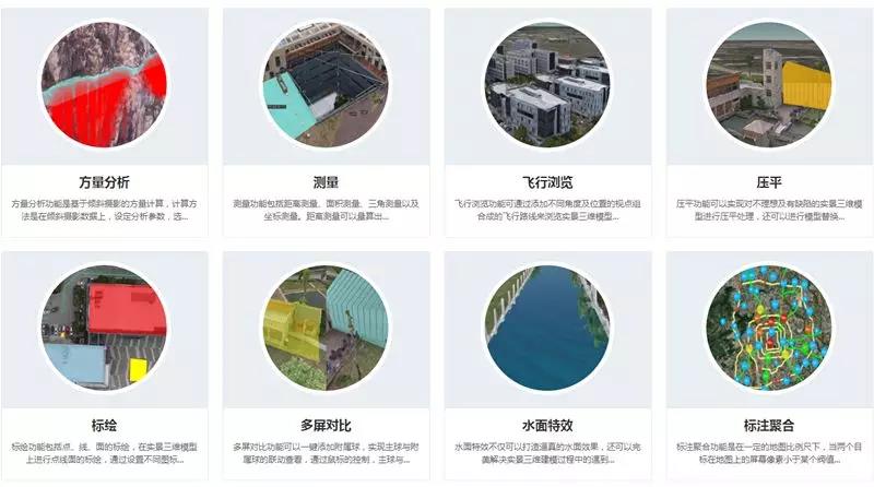
Based on the geographic information industry and cultural base of the Chinese Academy of Sciences, Tuxin focuses on the 3D application of oblique photography and has been deeply involved in the 3D GIS industry for nearly 10 years. It has successively launched a series of real-world 3D model application software: LocaSpace, a desktop 3D digital earth software; Wish3D, a lightweight real-world 3D data publishing tool; Wish3D Earth, a web-based 3D earth based on WebGL technology. The release of real 3D data is simple and convenient, supports large data volumes, and has rich 3D data application functions, which can be used for secondary development on demand.