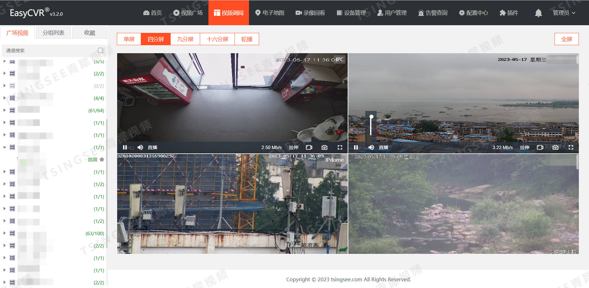
1. Introduction to the platform
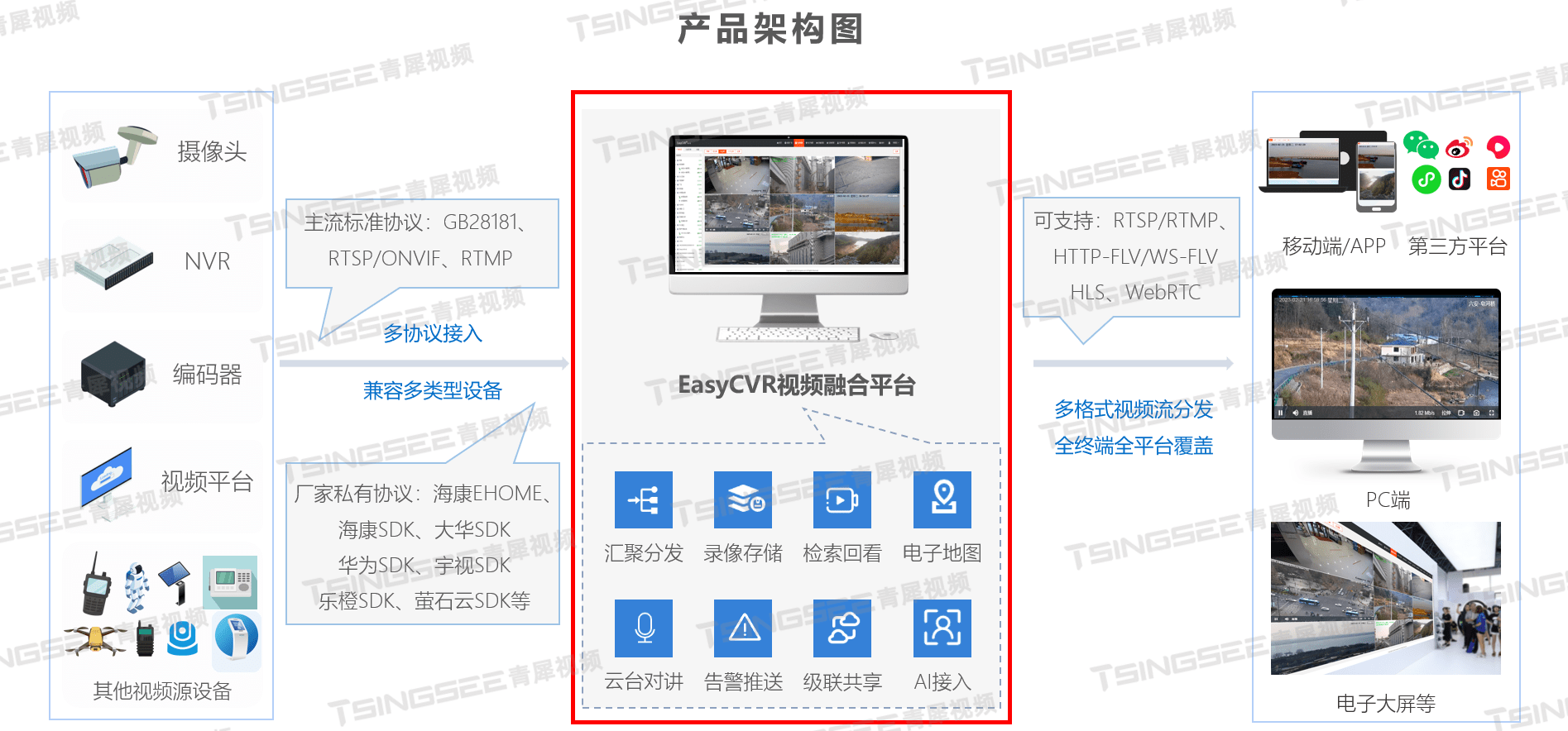
EasyCVR national standard video fusion cloud platform is a video fusion + AI intelligent analysis gateway platform based on the end-edge-cloud integrated architecture. The EasyCVR platform supports video convergence and integrated management, and is compatible with multi-type devices and multi-protocol access. The video functions it provides include: video surveillance, plug-in-free live recording, cloud storage, retrieval playback, intelligent alarm, platform cascading, GIS positioning monitoring, etc. EasyCVR has powerful video integration capabilities and AI cloud-side-device scheduling capabilities, and can implement services such as computing power allocation, resource scheduling, computing and storage, intelligent processing, and agile deployment based on device, edge, and cloud architectures.
2. A picture of video resource management
The video resource management map of the EasyCVR platform and the point search function support the basic situation and distribution of video resources based on the GIS map in the region. Users can search by point name keywords, and perform classified searches according to location type, applicability, sharing authority, camera type, video label, etc. At the same time, the user can clear the search categories with one click, and select points to be applied for in batches through box selection, circle selection, polygon selection, line selection, and click selection. In addition, users can also filter points by permission status and network status, and support the eagle eye map function, and view the detailed information of the point by clicking on the video point on the map.

3. Scenario application
Land and resources monitoring: use GPS, GIS, mobile Internet and other technologies to realize the functions of land and resources field project inspection, data collection, data transmission, data processing and distribution, real-time data query analysis, navigation and positioning, etc. It provides an operation platform for field work of land and resources management, such as field inspection of construction land start and completion, field inspection of cultivated land occupation and compensation balance, field inspection of land law enforcement, and annual change investigation, so as to improve the quality and efficiency of management.
Digital forestry: focus on resource management, forest and grassland fire prevention, pest control and wildlife monitoring, build a "forest and grass perception network" construction, continuously improve forest and grass data collection capabilities, and realize real-time and accurate industry supervision and efficiency. Effectively protect forest and grass resources, promote the modernization of the forest and grass industry governance system and governance capabilities, and contribute to the promotion of green development and ecological benefits to the people.
Water affairs management: Through information collection and GIS display functions, the situation of water affairs monitoring points within the jurisdiction is displayed in real time, including the direction of the canal system of each business point, the scope of the project location, the operating status of business monitoring points and gate control points, etc. Users can directly and interactively view the real-time status of various types of monitoring points on site in a single graph. At the same time, the platform also provides water regime information, water diversion information, water retreat information and project status information, providing relevant data for different levels.

Smart emergency response: "One map" of smart emergency response covers multiple fields such as typhoon storms, mountain ponds, reservoirs, floods, geological disasters, production and operation, road traffic, marine fishery ships, and city gas. Through spatial analysis technology, users can quickly query the nearby key defense protection objects and surrounding emergency resources. It realizes real-time dynamic display of data resources of rescue command and dispatch, accurate and intelligent analysis, and provides intelligent support for the whole process of emergency management. Through the precise and intelligent management of emergency risks, the capabilities of forecasting, early warning, and command and rescue have been greatly improved, and the risk prevention and resolution mechanisms in the whole process of resource integration, risk research and judgment, emergency decision-making, coordinated disposal, and comprehensive command have been further improved.
4. Advantages of the platform
Strong video access compatibility: support compatibility with different brands, different models, and different types of video streams (rtsp/rtmp/http/onvif), equipment (IPC/NVR/4(5)G law enforcement recorders) and monitoring platforms (GB28181 /EHome) to access the EasyCVR video fusion system to solve technical compatibility issues.
Video network aggregation and sharing: the platform has the ability of video network aggregation and sharing, and supports the network aggregation, point management, video query, access and application management of video resources of various systems.
Lightweight video access and distribution: the platform has lightweight access, transmission, processing and distribution capabilities, supports RTSP/ONVIF protocol access devices, can access multiple high-definition video streams, and supports distribution of RTSP/RTMP/FLV/HLS /WebRTC video stream format.

Visual data analysis: The platform can visually display the results of AI intelligent detection and analysis of the data collected by the equipment, including intelligently identified personnel, objects, behaviors and other violations. Realize a visualized, integrated, and intelligent data fusion analysis, management, and display platform.
Rapid integration and development: the platform provides a unified service HTTP Restful API interface, which facilitates rapid integration of third-party platforms. It meets the application scenarios of comprehensive urban governance and large database construction in the fields of public security, transportation, urban management, three-defense emergency and other social management and public safety, and meets the business expansion needs of different functional departments.
Efficiently empowering industries: Provide video resource sharing service capabilities for industries such as energy metallurgy, urban management, natural ecology, emergency management, smart buildings, financial services, public services, manufacturing, and industrial construction.