Latitude and longitude are the combination of longitude and latitude to form a coordinate system, called geographic coordinate system, which is a spherical coordinate system that uses a three-dimensional spherical surface to define the space on the earth, and can mark any position on the earth. When students in the first grade of junior high school are learning geography, they will soon learn the concept of latitude and longitude. Indeed, this concept is not so easy to understand, especially when doing geography exam questions, when you see all kinds of questions about azimuth, longitude and latitude, you will immediately get confused. Indeed, I also found it a little difficult when I learned this knowledge point in the first grade of junior high school, but as long as you master the core points of latitude and longitude knowledge, you will be able to master the subject of latitude and longitude. I hope this article of mine can help some junior high school students, or people who want to understand geography, have a deeper understanding of the concept of latitude and longitude. In this article, the concept of knowledge will not be described in detail, but more about the understanding and application of knowledge (a former junior high school student told me that I was confused when doing the questions, so An article dedicated to ta)
What are latitude and longitude (Coordinates)?
Latitude and longitude are the combination of longitude and latitude to form a coordinate system, called geographic coordinate system, which is a spherical coordinate system that uses a three-dimensional spherical surface to define the space on the earth, and can mark any position on the earth. Please forgive me for copying the concept from the beginning of the article, but this is the best explanation of latitude and longitude.
This is a simple map of latitude and longitude. You can see the vertical and horizontal lines on the earth, called the latitude and longitude network.
So when studying the orientation of the earth, which concepts will we use?
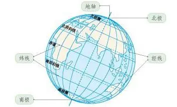
The earth rotates around an axis, which is called the earth's axis. The Earth's axis is an imaginary axis that can be used to study many geographical issues. Where the Earth's axis intersects the Earth's surface are the Earth's poles—the South Pole and the North Pole. Longitude and latitude are the professional language we use when we study the orientation of anything on earth. Many students will not know the warp and latitude, remember a formula: vertical longitude and horizontal latitude.
Longitude, longitude, time difference and time zone (Longitude, Time difference and time zone)
On a globe, the vertical lines are longitudes. In the global map, sometimes an interval of 15° or 20° may be used. Longitude often determines the time of a country and the alternation of day and night, because the order of the sun's rays in areas with different longitudes is also different, resulting in time differences. The topic of time difference often appears in the geography exam in the first grade of junior high school, and it is still a popular topic. When it comes to jet lag, you have to talk about time zones. Everyone first remember the time zones of several important places. For specific time zone tables, you can find the geographical atlas.
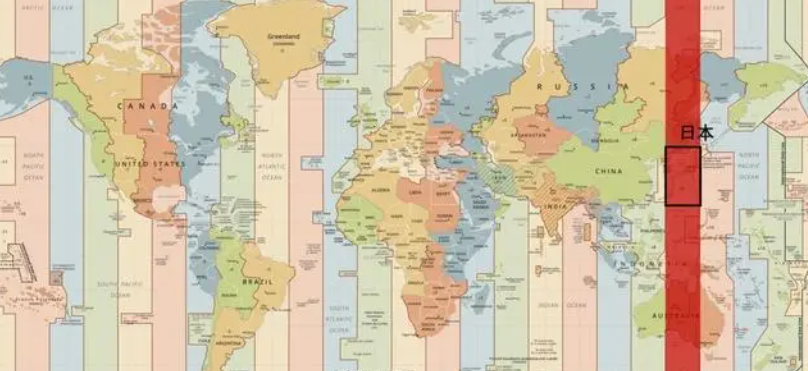
In this global time zone table, you will find that the division of each time zone is not drawn in a straight line, but there are many twists and turns. Because some countries span several time zones, but they don't want their own country to have multiple times, so they uniformly stipulate the time. For example, China uses Beijing time. Here, I will list the time zones of several big cities that are often tested. Shanghai, Beijing: East Eighth District. New York: West Fifth Ward. San Francisco: West Eighth Ward. Moscow: East Third District. Tokyo: East Nine Wards. Paris: 0 time zone. Bangkok: East Seventh District. To calculate the time difference, remember a mantra: difference addition and subtraction (two adjacent time zones, the time difference is one hour, and several time zones are separated, the time zone difference is a few hours. Subtraction is used for the same zone, and addition is used for different time zones)

For example: How many hours is the difference between East Eighth District and East Sixth District? (Subtract for the same time zone)
Answer: 8-6=2 2 hours
How many hours is the difference between East Seventh District and West Eighth District? (addition for different time zones)
Answer: 7+8=15 15 hours
The above few questions will lay the groundwork for the more complex questions that follow.
Next, I will give you a question: Given that Beijing time (East Eighth District) is 06:25 on April 8, 2020, what is the time in East Tenth District? What's the time in West Second District?
Everyone can think about it.
Answer: When doing this kind of questions, remember a mantra: add east and west subtract. (The format can be changed according to the teacher's request)
Adding east and subtracting west refers to: add the required time to the east of the known time, and subtract it to the west of the known time.
10-8=2 (the difference between East Eighth District and East Tenth District is two hours)
06:25 + 2 hours = 08:25
So the time in Dongshi District is 08:25 on April 8, 2020
8+2=10 (10 hours difference between East 8th District and West 2nd District)
06:25-10 hours = 20:25 (-1 day)
So the time in West Second District is 20:25 on April 7, 2020
When it comes to issues such as time difference and time zone, everyone needs to use it flexibly, and must be familiar with the knowledge.
Important longitude lines that need everyone's attention: Prime Meridian, International Date Line
Note: The meridian to the east of the prime meridian and the meridian to the west of the international date line are called east meridians
The longitude with the prime meridian as west and the international date line as east is called west longitude
Latitude, parallel (Latitude)
The latitude we usually refer to refers to the earth's latitude. Its value is between 0 and 90 degrees. The latitude of a point north of the equator is called north latitude, denoted as N; the latitude of a point south of the equator is called south latitude, denoted as S.
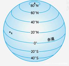

1. Remember the meaning of low latitude, middle latitude and high latitude, including the climate of these latitudes. Low-latitude regions have a hot climate, severe weather changes, and tall and luxuriant organisms. The prevailing air masses at high and low latitudes in the middle latitudes overlap each other in this area, with frequent cyclone activities and obvious seasonal changes. The climate in high latitudes is cold, and there will be Antarctic glaciers, special creatures, etc., polar day and polar night phenomena, etc.
2. When it comes to latitude, we must talk about the Tropic of Capricorn and the Tropic of Cancer.
The Tropic of Cancer is the dividing line where the sun moves back and forth directly on the earth every year. The Tropic of Cancer is the line of latitude with the latitude of 23°26′ south and north (the Tropic of Cancer: 23°26′N, the Tropic of Cancer 23°26′S). The Tropic of Capricornus is the farthest position that the sun can directly reach in the southern hemisphere, at about 23°26' south latitude, parallel to the line of latitude. Every year on the winter solstice, the point of direct sunlight reaches its maximum at the latitude of the southern hemisphere. The circles of latitude move round and round. Therefore, these two latitude circles are called the Tropic of Cancer and the Tropic of Capricorn respectively.
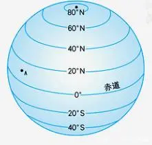
Between the Tropic of Cancer and the South is ( )
Choice: A (Tropical)
3. Will also talk about the equator
The equator is the starting point of the north-south latitude line (that is, the zero-degree latitude line), which is the longest latitude line on the earth.
North of the equator ( ), south of the equator ( )
Answer: North Latitude, South Latitude
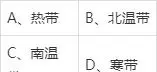
4. The Five Belts of the Earth
Most of my country is in the northern temperate zone, and the Leizhou Peninsula in Guangdong, the southern tip of Taiwan, Hainan Island and the South Yunnan Valley (southern Yunnan) are in the tropics.
Then these questions have been clarified for everyone, and then I will show you a few comprehensive questions.
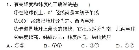
The second and fourth concepts are wrong, so the answer is: one or three is correct, choose D
Second: It is not the 180° meridian that separates the eastern and western hemispheres.
East of 20°W to 160°E is the Eastern Hemisphere, west of 20°W to 160°E is the Western Hemisphere
There is no need to talk about the fourth one, consider the spherical surface

This question is very comprehensive and requires a lot of consideration.
The first condition: the east of the point is the western hemisphere, and the west is the eastern hemisphere. As mentioned before, the eastern hemisphere is from the east of 20°W to 160°E, and the western hemisphere is from the west of 20°W to 160°E. The left side of the 180° meridian is east longitude, and the right side is west longitude. Therefore, the point on the east longitude 160° to the left of the 180° meridian should be selected. Looking at the second condition again, the north of the point is the high latitude, and the south is the middle latitude. The dividing line between high latitudes and middle latitudes is 60 degrees north and south latitude. Needless to say, it is point d.
So choose D

This is a comprehensive question, and it is easy to encounter such big questions at the end of the test paper.
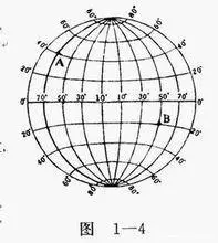
(1) It is easy to see that A is located at (60°S, 170°W) and C is located at (70°S, 170°E)
(2) The eastern hemisphere is to the right of 160° east longitude. Only B and D are in the Eastern Hemisphere. The boundary at high latitudes is 60°W or 60°N, and only B and D are located in high latitudes. Cold zone is also C and D. A and B are located in the temperate zone and need no explanation.
(3) The title of orientation is prone to confusion. A is at 170°W, and B is at 150°E. And we must be optimistic about the object "B", so A is directly east of B. C is to the south of A and also to the south of A, so it is southwest. As for the third space and the fourth space, there is basically no test, you just need to understand it. Answer: First go to the southwest, then to the west, then to the northwest, less than.
(4) This may be a combination of geography and mathematics, which can connect C, B and C and D.

This is also an extended topic. You can use the distance formula between two points in the second year of junior high school to establish coordinates to find the length of the two line segments. Of course, students in the first year of junior high school should not worry. The answer to this question is less than.
Today, I carefully discussed all types of latitude and longitude topics with you. Maybe I have some topics that I haven't covered yet, please forgive me. If you find any problems in my article, please point it out in the comment area, or send me a private message. Thank you for your support. I hope everyone can learn geography well, even if it is a minor subject.