1. Etiquetame etiqueta
Después de instalar labelme e iniciarlo, abrir el directorio comienza a etiquetar, seleccione Crear rectángulo
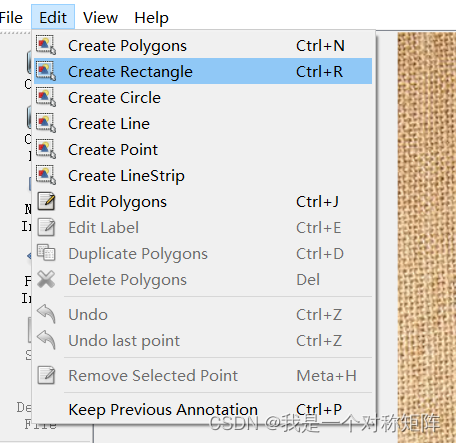
y arrastre el marco de la imagen, y luego seleccione una categoría (si no tiene una, simplemente ingrésela y se creará automáticamente), después de etiquetar un imagen, haga clic en la siguiente imagen y aparecerá un cuadro que le pedirá que guarde el archivo json, guárdelo.
Después de haber marcado todas las imágenes, no hay respuesta cuando hace clic en Siguiente imagen (porque no hay Siguiente imagen), en este momento, puede simplemente borrar el software labelme
Si guarda el archivo json en la carpeta de imágenes, debe tener la siguiente estructura:
- img1.jpg
- img1.json
- img2.jpg
- img2.json
- …
2. Convertir a formato coco
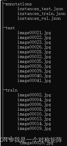
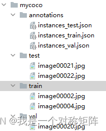
Supongamos que tengo un conjunto de datos de mycoco, que se ajusta al formato de conjunto de datos coco2017, entonces su estructura de directorios debería ser la siguiente:在mycoco文件夹下有4个文件夹:annotations(存放train、val和test的标注信息)、train(存放train集图片)、val(存放val集图片)、test(存放test集图片)
Ahora que hemos marcado la información con labelme, ¿cómo convertirla a la estructura de coco anterior?
#!/usr/bin/env python
# coding: utf-8
# Copyright (c) 2019 PaddlePaddle Authors. All Rights Reserved.
#
# Licensed under the Apache License, Version 2.0 (the "License");
# you may not use this file except in compliance with the License.
# You may obtain a copy of the License at
#
#     http://www.apache.org/licenses/LICENSE-2.0
#
# Unless required by applicable law or agreed to in writing, software
# distributed under the License is distributed on an "AS IS" BASIS,
# WITHOUT WARRANTIES OR CONDITIONS OF ANY KIND, either express or implied.
# See the License for the specific language governing permissions and
# limitations under the License.

import argparse
import glob
import json
import os
import os.path as osp
import shutil
import xml.etree.ElementTree as ET

import numpy as np
import PIL.ImageDraw
from tqdm import tqdm
import cv2

label_to_num = {

    }
categories_list = []
labels_list = []


class MyEncoder(json.JSONEncoder):
    def default(self, obj):
        if isinstance(obj, np.integer):
            return int(obj)
        elif isinstance(obj, np.floating):
            return float(obj)
        elif isinstance(obj, np.ndarray):
            return obj.tolist()
        else:
            return super(MyEncoder, self).default(obj)


def images_labelme(data, num):
    image = {

    }
    image['height'] = data['imageHeight']
    image['width'] = data['imageWidth']
    image['id'] = num + 1
    if '\\' in data['imagePath']:
        image['file_name'] = data['imagePath'].split('\\')[-1]
    else:
        image['file_name'] = data['imagePath'].split('/')[-1]
    return image


def images_cityscape(data, num, img_file):
    image = {

    }
    image['height'] = data['imgHeight']
    image['width'] = data['imgWidth']
    image['id'] = num + 1
    image['file_name'] = img_file
    return image


def categories(label, labels_list):
    category = {

    }
    category['supercategory'] = 'component'
    category['id'] = len(labels_list) + 1
    category['name'] = label
    return category


def annotations_rectangle(points, label, image_num, object_num, label_to_num):
    annotation = {

    }
    seg_points = np.asarray(points).copy()
    seg_points[1, :] = np.asarray(points)[2, :]
    seg_points[2, :] = np.asarray(points)[1, :]
    annotation['segmentation'] = [list(seg_points.flatten())]
    annotation['iscrowd'] = 0
    annotation['image_id'] = image_num + 1
    annotation['bbox'] = list(
        map(float, [
            points[0][0], points[0][1], points[1][0] - points[0][0], points[1][
                1] - points[0][1]
        ]))
    annotation['area'] = annotation['bbox'][2] * annotation['bbox'][3]
    annotation['category_id'] = label_to_num[label]
    annotation['id'] = object_num + 1
    return annotation


def annotations_polygon(height, width, points, label, image_num, object_num,
                        label_to_num):
    annotation = {

    }
    annotation['segmentation'] = [list(np.asarray(points).flatten())]
    annotation['iscrowd'] = 0
    annotation['image_id'] = image_num + 1
    annotation['bbox'] = list(map(float, get_bbox(height, width, points)))
    annotation['area'] = annotation['bbox'][2] * annotation['bbox'][3]
    annotation['category_id'] = label_to_num[label]
    annotation['id'] = object_num + 1
    return annotation


def get_bbox(height, width, points):
    polygons = points
    mask = np.zeros([height, width], dtype=np.uint8)
    mask = PIL.Image.fromarray(mask)
    xy = list(map(tuple, polygons))
    PIL.ImageDraw.Draw(mask).polygon(xy=xy, outline=1, fill=1)
    mask = np.array(mask, dtype=bool)
    index = np.argwhere(mask == 1)
    rows = index[:, 0]
    clos = index[:, 1]
    left_top_r = np.min(rows)
    left_top_c = np.min(clos)
    right_bottom_r = np.max(rows)
    right_bottom_c = np.max(clos)
    return [
        left_top_c, left_top_r, right_bottom_c - left_top_c,
        right_bottom_r - left_top_r
    ]


def deal_json(ds_type, img_path, json_path):
    data_coco = {

    }
    images_list = []
    annotations_list = []
    image_num = -1
    object_num = -1
    for img_file in os.listdir(img_path):
        img_label = os.path.splitext(img_file)[0]
        if img_file.split('.')[
                -1] not in ['bmp', 'jpg', 'jpeg', 'png', 'JPEG', 'JPG', 'PNG']:
            continue
        label_file = osp.join(json_path, img_label + '.json')
        print('Generating dataset from:', label_file)
        image_num = image_num + 1
        with open(label_file) as f:
            data = json.load(f)
            if ds_type == 'labelme':
                images_list.append(images_labelme(data, image_num))
            elif ds_type == 'cityscape':
                images_list.append(images_cityscape(data, image_num, img_file))
            if ds_type == 'labelme':
                for shapes in data['shapes']:
                    object_num = object_num + 1
                    label = shapes['label']
                    if label not in labels_list:
                        categories_list.append(categories(label, labels_list))
                        labels_list.append(label)
                        label_to_num[label] = len(labels_list)
                    p_type = shapes['shape_type']
                    if p_type == 'polygon':
                        points = shapes['points']
                        annotations_list.append(
                            annotations_polygon(data['imageHeight'], data[
                                'imageWidth'], points, label, image_num,
                                                object_num, label_to_num))

                    if p_type == 'rectangle':
                        (x1, y1), (x2, y2) = shapes['points']
                        x1, x2 = sorted([x1, x2])
                        y1, y2 = sorted([y1, y2])
                        points = [[x1, y1], [x2, y2], [x1, y2], [x2, y1]]
                        annotations_list.append(
                            annotations_rectangle(points, label, image_num,
                                                  object_num, label_to_num))
            elif ds_type == 'cityscape':
                for shapes in data['objects']:
                    object_num = object_num + 1
                    label = shapes['label']
                    if label not in labels_list:
                        categories_list.append(categories(label, labels_list))
                        labels_list.append(label)
                        label_to_num[label] = len(labels_list)
                    points = shapes['polygon']
                    annotations_list.append(
                        annotations_polygon(data['imgHeight'], data[
                            'imgWidth'], points, label, image_num, object_num,
                                            label_to_num))
    data_coco['images'] = images_list
    data_coco['categories'] = categories_list
    data_coco['annotations'] = annotations_list
    return data_coco


def voc_get_label_anno(ann_dir_path, ann_ids_path, labels_path):
    with open(labels_path, 'r') as f:
        labels_str = f.read().split()
    labels_ids = list(range(1, len(labels_str) + 1))

    with open(ann_ids_path, 'r') as f:
        ann_ids = [lin.strip().split(' ')[-1] for lin in f.readlines()]

    ann_paths = []
    for aid in ann_ids:
        if aid.endswith('xml'):
            ann_path = os.path.join(ann_dir_path, aid)
        else:
            ann_path = os.path.join(ann_dir_path, aid + '.xml')
        ann_paths.append(ann_path)

    return dict(zip(labels_str, labels_ids)), ann_paths


def voc_get_image_info(annotation_root, im_id):
    filename = annotation_root.findtext('filename')
    assert filename is not None
    img_name = os.path.basename(filename)

    size = annotation_root.find('size')
    width = float(size.findtext('width'))
    height = float(size.findtext('height'))

    image_info = {


        'file_name': filename,
        'height': height,
        'width': width,
        'id': im_id
    }
    return image_info


def voc_get_coco_annotation(obj, label2id):
    label = obj.findtext('name')
    assert label in label2id, "label is not in label2id."
    category_id = label2id[label]
    bndbox = obj.find('bndbox')
    xmin = float(bndbox.findtext('xmin'))
    ymin = float(bndbox.findtext('ymin'))
    xmax = float(bndbox.findtext('xmax'))
    ymax = float(bndbox.findtext('ymax'))
    assert xmax > xmin and ymax > ymin, "Box size error."
    o_width = xmax - xmin
    o_height = ymax - ymin
    anno = {


        'area': o_width * o_height,
        'iscrowd': 0,
        'bbox': [xmin, ymin, o_width, o_height],
        'category_id': category_id,
        'ignore': 0,
    }
    return anno


def voc_xmls_to_cocojson(annotation_paths, label2id, output_dir, output_file):
    output_json_dict = {


        "images": [],
        "type": "instances",
        "annotations": [],
        "categories": []
    }
    bnd_id = 1  # bounding box start id
    im_id = 0
    print('Start converting !')
    for a_path in tqdm(annotation_paths):
        # Read annotation xml
        ann_tree = ET.parse(a_path)
        ann_root = ann_tree.getroot()

        img_info = voc_get_image_info(ann_root, im_id)
        output_json_dict['images'].append(img_info)

        for obj in ann_root.findall('object'):
            ann = voc_get_coco_annotation(obj=obj, label2id=label2id)
            ann.update({

    'image_id': im_id, 'id': bnd_id})
            output_json_dict['annotations'].append(ann)
            bnd_id = bnd_id + 1
        im_id += 1

    for label, label_id in label2id.items():
        category_info = {

    'supercategory': 'none', 'id': label_id, 'name': label}
        output_json_dict['categories'].append(category_info)
    output_file = os.path.join(output_dir, output_file)
    with open(output_file, 'w') as f:
        output_json = json.dumps(output_json_dict)
        f.write(output_json)


def widerface_to_cocojson(root_path):
    train_gt_txt = os.path.join(root_path, "wider_face_split", "wider_face_train_bbx_gt.txt")
    val_gt_txt = os.path.join(root_path, "wider_face_split", "wider_face_val_bbx_gt.txt")
    train_img_dir = os.path.join(root_path, "WIDER_train", "images")
    val_img_dir = os.path.join(root_path, "WIDER_val", "images")
    assert train_gt_txt
    assert val_gt_txt
    assert train_img_dir
    assert val_img_dir
    save_path = os.path.join(root_path, "widerface_train.json")
    widerface_convert(train_gt_txt, train_img_dir, save_path)
    print("Wider Face train dataset converts sucess, the json path: {}".format(save_path))
    save_path = os.path.join(root_path, "widerface_val.json")
    widerface_convert(val_gt_txt, val_img_dir, save_path)
    print("Wider Face val dataset converts sucess, the json path: {}".format(save_path))


def widerface_convert(gt_txt, img_dir, save_path):
    output_json_dict = {


        "images": [],
        "type": "instances",
        "annotations": [],
        "categories": [{

    'supercategory': 'none', 'id': 0, 'name': "human_face"}]
    }
    bnd_id = 1  # bounding box start id
    im_id = 0
    print('Start converting !')
    with open(gt_txt) as fd:
        lines = fd.readlines()

    i = 0
    while i < len(lines):
        image_name = lines[i].strip()
        bbox_num = int(lines[i + 1].strip())
        i += 2
        img_info = get_widerface_image_info(img_dir, image_name, im_id)
        if img_info:
            output_json_dict["images"].append(img_info)
            for j in range(i, i + bbox_num):
                anno = get_widerface_ann_info(lines[j])
                anno.update({

    'image_id': im_id, 'id': bnd_id})
                output_json_dict['annotations'].append(anno)
                bnd_id += 1
        else:
            print("The image dose not exist: {}".format(os.path.join(img_dir, image_name)))
        bbox_num = 1 if bbox_num == 0 else bbox_num
        i += bbox_num
        im_id += 1
    with open(save_path, 'w') as f:
        output_json = json.dumps(output_json_dict)
        f.write(output_json)


def get_widerface_image_info(img_root, img_relative_path, img_id):
    image_info = {

    }
    save_path = os.path.join(img_root, img_relative_path)
    if os.path.exists(save_path):
        img = cv2.imread(save_path)
        image_info["file_name"] = os.path.join(os.path.basename(
            os.path.dirname(img_root)), os.path.basename(img_root),
            img_relative_path)
        image_info["height"] = img.shape[0]
        image_info["width"] = img.shape[1]
        image_info["id"] = img_id
    return image_info


def get_widerface_ann_info(info):
    info = [int(x) for x in info.strip().split()]
    anno = {


        'area': info[2] * info[3],
        'iscrowd': 0,
        'bbox': [info[0], info[1], info[2], info[3]],
        'category_id': 0,
        'ignore': 0,
        'blur': info[4],
        'expression': info[5],
        'illumination': info[6],
        'invalid': info[7],
        'occlusion': info[8],
        'pose': info[9]
    }
    return anno


def main():
    parser = argparse.ArgumentParser(
        formatter_class=argparse.ArgumentDefaultsHelpFormatter)
    parser.add_argument(
        '--dataset_type',
        help='the type of dataset, can be `voc`, `widerface`, `labelme` or `cityscape`')
    parser.add_argument('--json_input_dir', help='input annotated directory')
    parser.add_argument('--image_input_dir', help='image directory')
    parser.add_argument(
        '--output_dir', help='output dataset directory', default='./')
    parser.add_argument(
        '--train_proportion',
        help='the proportion of train dataset',
        type=float,
        default=1.0)
    parser.add_argument(
        '--val_proportion',
        help='the proportion of validation dataset',
        type=float,
        default=0.0)
    parser.add_argument(
        '--test_proportion',
        help='the proportion of test dataset',
        type=float,
        default=0.0)
    parser.add_argument(
        '--voc_anno_dir',
        help='In Voc format dataset, path to annotation files directory.',
        type=str,
        default=None)
    parser.add_argument(
        '--voc_anno_list',
        help='In Voc format dataset, path to annotation files ids list.',
        type=str,
        default=None)
    parser.add_argument(
        '--voc_label_list',
        help='In Voc format dataset, path to label list. The content of each line is a category.',
        type=str,
        default=None)
    parser.add_argument(
        '--voc_out_name',
        type=str,
        default='voc.json',
        help='In Voc format dataset, path to output json file')
    parser.add_argument(
        '--widerface_root_dir',
        help='The root_path for wider face dataset, which contains `wider_face_split`, `WIDER_train` and `WIDER_val`.And the json file will save in this path',
        type=str,
        default=None)
    args = parser.parse_args()
    try:
        assert args.dataset_type in ['voc', 'labelme', 'cityscape', 'widerface']
    except AssertionError as e:
        print(
            'Now only support the voc, cityscape dataset and labelme dataset!!')
        os._exit(0)

    if args.dataset_type == 'voc':
        assert args.voc_anno_dir and args.voc_anno_list and args.voc_label_list
        label2id, ann_paths = voc_get_label_anno(
            args.voc_anno_dir, args.voc_anno_list, args.voc_label_list)
        voc_xmls_to_cocojson(
            annotation_paths=ann_paths,
            label2id=label2id,
            output_dir=args.output_dir,
            output_file=args.voc_out_name)
    elif args.dataset_type == "widerface":
        assert args.widerface_root_dir
        widerface_to_cocojson(args.widerface_root_dir)
    else:
        try:
            assert os.path.exists(args.json_input_dir)
        except AssertionError as e:
            print('The json folder does not exist!')
            os._exit(0)
        try:
            assert os.path.exists(args.image_input_dir)
        except AssertionError as e:
            print('The image folder does not exist!')
            os._exit(0)
        try:
            assert abs(args.train_proportion + args.val_proportion \
                    + args.test_proportion - 1.0) < 1e-5
        except AssertionError as e:
            print(
                'The sum of pqoportion of training, validation and test datase must be 1!'
            )
            os._exit(0)

        # Allocate the dataset.
        total_num = len(glob.glob(osp.join(args.json_input_dir, '*.json')))
        if args.train_proportion != 0:
            train_num = int(total_num * args.train_proportion)
            out_dir = args.output_dir + '/train'
            if not os.path.exists(out_dir):
                os.makedirs(out_dir)
        else:
            train_num = 0
        if args.val_proportion == 0.0:
            val_num = 0
            test_num = total_num - train_num
            out_dir = args.output_dir + '/test'
            if args.test_proportion != 0.0 and not os.path.exists(out_dir):
                os.makedirs(out_dir)
        else:
            val_num = int(total_num * args.val_proportion)
            test_num = total_num - train_num - val_num
            val_out_dir = args.output_dir + '/val'
            if not os.path.exists(val_out_dir):
                os.makedirs(val_out_dir)
            test_out_dir = args.output_dir + '/test'
            if args.test_proportion != 0.0 and not os.path.exists(test_out_dir):
                os.makedirs(test_out_dir)
        count = 1
        for img_name in os.listdir(args.image_input_dir):
            if count <= train_num:
                if osp.exists(args.output_dir + '/train/'):
                    shutil.copyfile(
                        osp.join(args.image_input_dir, img_name),
                        osp.join(args.output_dir + '/train/', img_name))
            else:
                if count <= train_num + val_num:
                    if osp.exists(args.output_dir + '/val/'):
                        shutil.copyfile(
                            osp.join(args.image_input_dir, img_name),
                            osp.join(args.output_dir + '/val/', img_name))
                else:
                    if osp.exists(args.output_dir + '/test/'):
                        shutil.copyfile(
                            osp.join(args.image_input_dir, img_name),
                            osp.join(args.output_dir + '/test/', img_name))
            count = count + 1

        # Deal with the json files.
        if not os.path.exists(args.output_dir + '/annotations'):
            os.makedirs(args.output_dir + '/annotations')
        if args.train_proportion != 0:
            train_data_coco = deal_json(args.dataset_type,
                                        args.output_dir + '/train',
                                        args.json_input_dir)
            train_json_path = osp.join(args.output_dir + '/annotations',
                                       'instance_train.json')
            json.dump(
                train_data_coco,
                open(train_json_path, 'w'),
                indent=4,
                cls=MyEncoder)
        if args.val_proportion != 0:
            val_data_coco = deal_json(args.dataset_type,
                                      args.output_dir + '/val',
                                      args.json_input_dir)
            val_json_path = osp.join(args.output_dir + '/annotations',
                                     'instance_val.json')
            json.dump(
                val_data_coco,
                open(val_json_path, 'w'),
                indent=4,
                cls=MyEncoder)
        if args.test_proportion != 0:
            test_data_coco = deal_json(args.dataset_type,
                                       args.output_dir + '/test',
                                       args.json_input_dir)
            test_json_path = osp.join(args.output_dir + '/annotations',
                                      'instance_test.json')
            json.dump(
                test_data_coco,
                open(test_json_path, 'w'),
                indent=4,
                cls=MyEncoder)


if __name__ == '__main__':
    """
    python tools/x2coco.py \
                --dataset_type labelme \
                --json_input_dir ./labelme_annos/ \
                --image_input_dir ./labelme_imgs/ \
                --output_dir ./mycoco/ \
                --train_proportion 0.8 \
                --val_proportion 0.2 \
                --test_proportion 0.0
    """
    main()
El código anterior se toma de la detección de paletas (debo decir que Baidu tiene muchos scripts pequeños), a través de los parámetros de la línea de comando:
python tools/x2coco.py \
            --dataset_type labelme \
            --json_input_dir ./labelme_annos/ \
            --image_input_dir ./labelme_imgs/ \
            --output_dir ./mycoco/ \
            --train_proportion 0.8 \
            --val_proportion 0.2 \
            --test_proportion 0.0
- dataset_type: convertir labelme a coco, bloqueado aquí es labelme por defecto
- json_input_dir: la ruta al archivo json de labelme
- image_input_dir: apunta a la ruta del archivo img de labelme (aquí json e img son la misma ruta)
- output_dir: la ruta de la carpeta de salida después de la conversión a coco
- train_proportion, val_proportion, test_proportion: la proporción del conjunto de datos dividido, en resumen, la suma de los tres debe ser 1
Después de una ejecución exitosa, puede ver la carpeta mycoco:
注意:虽然现在目录结构上和coco一致了,但是在很多开源目标检测项目中,默认的文件名字不太一样,比如有的文件夹为train2017、val2017和test2017,或者annotations中的文件名为instances_train.json(多了一个s),请结合实际情况修改即可
3. Visualización de etiquetas
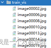
Después de etiquetar con labelme y convertirlo a formato coco, queremos visualizar el conjunto de datos de coco, podemos usar el siguiente código:
import cv2
import os
from pycocotools.coco import COCO


labels=['eye','noise','mouth']  # 分类标签名
img_path = 'mycoco/train' # 比如我需要可视化train集
annFile = 'mycoco/annotations\instances_train.json'  # 指定train集的json文件
save_path = 'mycoco/train_vis'   # 可视化结果的保存路径

if not os.path.exists(save_path):
    os.makedirs(save_path)

def draw_rectangle(coordinates, image, image_name,color=(0,255,0),thickness=1,fontScale=0.5):
    """

    @param coordinates: 所有框的信息[[left,top,right,bottom],[left,top,right,bottom],...]
    @param image:
    @param image_name:
    @param color: 框和文字的颜色,默认绿色
    @param thickness: 框线条的粗细
    @param fontScale: 字体大小
    @return:
    """
    for coordinate in coordinates:  # 遍历每一个框信息
        left, top, right, bottom = map(int, coordinate[:-1])
        label=coordinate[-1]
        cv2.rectangle(image, (left, top), (right, bottom), color, thickness)
        cv2.putText(image, str(label), (left, top), cv2.FONT_HERSHEY_SIMPLEX, fontScale, color, thickness)

    cv2.imwrite(save_path + '/' + image_name, image)


coco = COCO(annFile)
imgIds = coco.getImgIds()  # 获取每张图片的序号

for imgId in imgIds:
    img = coco.loadImgs(imgId)[0]   #加载图片信息
    image_name = img['file_name']   # 获取图片名字
    annIds = coco.getAnnIds(imgIds=img['id'], catIds=[], iscrowd=None)  # 根据图片id获取与该id相关联的anno的序号
    anns = coco.loadAnns(annIds)    # 根据anno序号获取anno信息

    coordinates = []
    img_raw = cv2.imread(os.path.join(img_path, image_name))
    for j in range(len(anns)):
        coordinate = anns[j]['bbox']    # 遍历每一个anno,获取到框信息,[left,top,width,heigh]
        coordinate[2] += coordinate[0]  # 计算得到right
        coordinate[3] += coordinate[1]  # 计算得到bottom
        coordinate.append(labels[anns[j]['category_id']-1])   # 追加分类标签,形成[left,top,right,bottom,label]
        coordinates.append(coordinate)  # [[left,top,right,bottom],[left,top,right,bottom],...]

    draw_rectangle(coordinates, img_raw, image_name)
Obtendrá el dibujo de la información de la etiqueta: